Turmstrasse (Berlin)
| Turmstrasse | |
|---|---|
| Street in Berlin | |
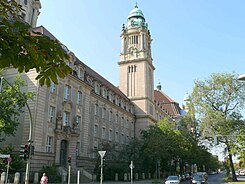
| Moabit Criminal Court | |
| Basic data | |
| place | Berlin |
| District | Moabit |
| Created | 1827 |
| Hist. Names | Ernst-Thälmann-Strasse (briefly 1945) |
| Connecting roads | Huttenstrasse |
| Cross streets |
(Selection) Rathenower Strasse , Wilsnacker Strasse , Stromstrasse , Gotzkowskystrasse , Waldstrasse , Beusselstrasse |
| Places | Mathilde-Jacob-Platz |
| Buildings |
Moabit Criminal Court , Moabit Hospital , Tiergarten City Hall |
| use | |
| User groups | Pedestrian traffic , bicycle traffic , automobile traffic , public transport |
| Technical specifications | |
| Street length | 1800 meters |
The Tower Road is a major route in the Berlin district of Moabit of the district center .
Course and history
Today it leads from Rathenower Strasse in the east to Beusselstrasse and from there it continues as Huttenstrasse . When the road was laid out in 1827, it still ran to today's Heidestrasse . Barracks and military facilities were later built on the easternmost section. Today there is the Fritz-Schloß-Park with the Poststadion and the Stadtbad Tiergarten .
The road had three lanes in each direction over its entire length of 1,800 meters. There are currently two lanes in each direction between Beusselstrasse and Stromstrasse . On the section from Stromstrasse to Rathenower Strasse, only one lane is released for motor traffic, while the second lane serves as a cycle path. The directions of travel are largely separated by a green strip along the entire length of the road .
The Turmstrasse allegedly got its name as a line of sight between the towers of the Sophienkirche in today's district of Mitte and the Nikolaikirche in the then still independent town of Spandau . However, according to new findings, this is not true. After the end of the Second World War , it was named Ernst-Thälmann-Strasse for a few months in memory of the murdered KPD chairman Ernst Thälmann . In view of the political changes in the western part of Berlin in the post-war period , the street was renamed back at the end of 1945.

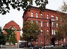
As the seat of the most important administrations and shops of the former Tiergarten district , the street gained importance at the district level. In addition to the Berlin Criminal Court, the Moabit Hospital was also located here - for decades the most important hospital in Berlin alongside the Charité . In the Tiergarten town hall on Mathilde-Jacob-Platz , the authorities and administrations of the Mitte district office are now located. The State Office for Health and Social Affairs (LAGeSo) is located further east at Turmstrasse 21. The Kleine Tiergarten , located between Turmstrasse and Alt-Moabit , was laid out as a district park in the 19th century and redesigned in the 1960s after being destroyed by the war. Immediately to the west of the Kleiner Tiergarten, opposite the town hall, is the Heilandskirche on Thusnelda-Allee , Berlin's shortest avenue at 50 meters. In addition to some bus lines, Turmstrasse is connected to the U9 subway station of the same name and the Berlin subway network.
Web links
-
Turmstrasse. In: Street name lexicon of the Luisenstädtischer Bildungsverein (near Kaupert )
- Ernst-Thalmann-Strasse . In: Luise.
- Turmstrasse in the district lexicon of the Luisenstädtischer Bildungsverein
- Complete course on a city map from 1837 at alt-berlin.info
Individual evidence
- ↑ Turmstrasse no line of sight between towers. In: Berliner Woche , October 14, 2018
Coordinates: 52 ° 31 ′ 34.7 " N , 13 ° 20 ′ 34.9" E
