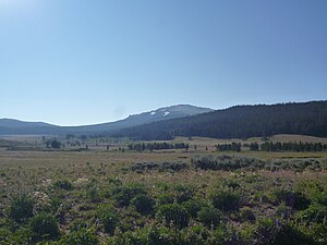
Union Peak, Wyoming
| Union Peak | ||
|---|---|---|
|
Union Peak from the northwest, from Union Pass Road |
||
| height | 3502 m | |
| location | Sublette County , Wyoming , USA | |
| Mountains | Northern Wind River Range , Rocky Mountains | |
| Notch height | 302 m | |
| Coordinates | 43 ° 27 '19 " N , 109 ° 47' 15" W | |
|
|
||
The Union Peak ( 3502 m ) is a mountain in the northern Wind River Range in the Rocky Mountains . It is located in Sublette County in the state of Wyoming about seven kilometers southeast of Union passport , a transition which earlier by Indians , trappers and fur traders was used. Both the pass and the mountain are part of the North American Continental Divide . The name of the mountain and pass was created by William F. Raynolds in 1860 when he was crossing the pass under the guidance of Jim Bridger .
Location and surroundings
Union Peak is the last, most north-westerly summit in the south-east to north-west trending main ridge of the Wind River Range , which is part of the Continental Divide . In the area of Union Peaks, this ridge also forms the border between the Shoshone National Forest in the northeast and the Bridger-Teton National Forest in the southwest.
The mountain shows mainly grassy flanks on all sides, interrupted by a few rocky, granite-like outcrops , especially in the area of the summit ridge, which is almost flat for a few hundred meters and running in a southeastern direction. The terrain is not particularly steep, the average slope is 10 degrees. The earlier glaciation can be seen in the form of the remnants of moraine structures. The soils are poorly developed and the erosion is moderate. The tree line is around 3100 m , individual trees can be found up to 3170 m . Above that there is alpine tundra with undemanding grasses, sedges , herbaceous plants , and low, wooden shrubs, as well as occasional crooked wood in the form of the white-stemmed pine ( Pinus albicaulis ), which can be found in some places up to an altitude of 3200 m .
The next peak in the main ridge is south of the Three Waters Mountain ( 3566 m ), a little over 8 kilometers away , the deepest saddle between these mountains is about 3200 m . The Three Waters Mountain forms a triple watershed , the water flowing off its flanks flows over the Mississippi into the Gulf of Mexico , over the Columbia River into the Pacific and over the Colorado into the Gulf of California .
Alpinism
Usually the mountain is climbed from the northwest. The starting point is usually near the Union Pass . This can be achieved by the Highway 287 / 26 on a dirt road, the Union Pass Road . This is to follow from the junction from the highway a little over 20 kilometers south.
On this route, it makes sense to initially follow the so-called Seven Lakes Road , a path that can only be driven off-road vehicles, which branches off the Union Pass Road a little over a kilometer northeast of the pass in a southeast direction. Immediately after the junction there is a stream to cross, the South Fork Warm Spring Creek . The Seven Lakes Road climbs to the east, changing from the northern to the southern side of the continental divide. Above the tree line, at an altitude of about 3,140 meters, when the road turns south, it can be left to strive for the main ridge in a north-easterly direction without a path. Via this the summit can be reached easily in an easterly direction. The difficulty of this hike is given as Class 1 or Class 2 in the Yosemite Decimal System , the time required from Union Pass Road to the summit is around 3.5 hours.
Individual evidence
- ↑ a b c Union Peak at listsofjohn.com, accessed on November 21, 2017
- ^ Union Pass Road - Environmental Impact Statement. USDA Forest Service, Bridger-Teton National Forest, February 1993, S I-7
- ↑ a b Union Peak ( Memento of the original from December 1, 2017 in the Internet Archive ) Info: The archive link was automatically inserted and not yet checked. Please check the original and archive link according to the instructions and then remove this notice. at Wyoming Places, accessed November 21, 2017
- ↑ John Daugherty: Explorers and Scientists. In: A Place Called Jackson Hole. A Historic Resource Study of Grand Teton National Park. Grand Teton Natural History Association, Moose 1999
- ^ A b Joe Kelsey: Climbing and Hiking in the Wind River Mountains. Third edition. FalconGuides, Guilford (Connecticut) 2013, ISBN 0-7627-8078-9 , p. 76 ( Google books ).
- ↑ Christopher Morgan, Ashley Losey, Lukas Trout: Late-Holocene paleoclimate and treeline fluctuation in Wyoming's Wind River Range, USA. In: The Holocene. Volume 214, pp. 209-219, 2014 ( online ).
- ↑ a b Union Peak at summitpost.org, accessed on November 21, 2017
Web links
- Union Peak at summitpost.org

