
Unterfrinig

The mountain farm Unterfrinig is on 1715 m at the edge of the Sonnenberg above the fraction Eyrs in Vinschgau in South Tyrol . It belongs to the area of the Tanas fraction of the municipality of Laas .
After the Oberfrinig farm ( 1745 m ) and the Strimmhof ( 1754 m ), it is the third highest farm in Laas.
The ensemble consists of a double courtyard (Unterfrinig I and Unterfrinig II) both of which are built wall to wall. These include stable, barn and a chapel. Residential building I is a late Gothic building with a painted facade. Under the roof ridge is the year 1576, including another year 1807 and the initials RV, which suggests a renovation. The living room has a joist, the hallway and the kitchen are equipped with a vaulted ceiling. On the right side is the late Gothic house II.
The chapel was profaned at an unknown date .
The farm was first mentioned in a document in 1352. Jakob Niederfriniger is named as the owner in 1552. In 1571 Hans and Leonhard Niederfriniger appear as owners of the Unterfrinighof. Bartholomäus Radi was the owner in 1779 and Thomas Parth in 1855.
A new courtyard was built in the immediate vicinity some time ago: some of the old buildings have fallen into disrepair and are in a ruinous condition. The barn collapsed a long time ago and most of the rubble has already been cleared. The roof of the main house has collapsed in places. The extension is in a better condition than the main building, especially here the roof has recently been covered with folded sheet metal and thus sealed. The condition of the chapel is also very poor, but it was makeshiftly secured with plastic sheeting against rain and snow. It was equipped with a small bell from 1681, which was rung when there was a risk of thunderstorms. Between the world wars, the farm belonged to a Gottlieb Steck who first leased it to the Pircher family and then sold it.
In the middle of the 20th century the following fields and meadows belonged to the farm:
- Talacker
- Lower Ruth
- Upper diamond
- 10 Teinenwiesen
- 3 ladder meadows
- Lochwiese
- Blaaswiese
- View oaths
- Home garden
On May 12, 1981, the homestead was protected as a monument according to BLR-LAB 2536.

Documentation of the poor state of preservation

The poorly secured chapel, in the background part of the newly built courtyard
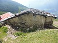
The partially collapsed roof of House I, on the left you can see the new roofing of House II with folded sheet metal


literature
- Franz Waldner, Harbert Raffeiner, Hermann Schönthaler, Isidor Schönthaler, Wilfried Stimpfl, Johann E. Thumler, Manfred Zangerle: Houses from Laas, Tschengls, Eyrs, Tanas, Alitz. A picture documentation from the option period 1939/40. Tappeiner, Lana 1990.
Web links
- Entry in the monument browser on the website of the South Tyrolean Monuments Office

Laas:
Alter Pfarrwieden |
Albert Peter |
Bauernmühl |
Gasthaus Sonne |
Gasthof zur Krone |
Josefshaus |
Oberlorezhof |
Obermühl |
Maria Lourdes |
Moarhof |
Prüllhof |
Black cobbler |
Rungghof |
School house |
St. John |
St. Mark |
St. Martin |
St. Nicholas |
St. Sisinius
Eyrs:
Lamplwirt |
Moosburg |
Plawenngut |
St. Joseph |
St. Remigius |
Voglsang
Tschengls:
Alter Wieden |
Birth of Mary |
Perlinger |
Psegg |
Riglguot |
St. Ottilia
Allitz:
Marienkapelle |
Visitation of the Virgin Mary |
St. Moritz
Tanas:
Church of the Sacred Heart of Jesus |
Platthof |
Röderhof |
St. Anna |
St. Peter |
Unterfrinighof
Tarnell:
Ortisei (Tarnell)
Parnetz:
Marienkapelle
Coordinates: 46 ° 39 ′ 9.7 ″ N , 10 ° 39 ′ 19 ″ E