Ura Vajgurore
|
Urë Vajgurore Ura Vajgurore |
||

|
||
|
Coordinates: 40 ° 47 ' N , 19 ° 53' E |
||
| Basic data | ||
|---|---|---|
| Qark : | Advises | |
| Municipality : | Ura Vajgurore | |
| Height : | 40 m above sea level A. | |
| Residential place : | 7232 (2011) | |
| Bashkia residents : | 27,295 (2011) | |
| Telephone code : | (+355) 361 | |
| Postal code : | 5007 | |
| Politics and administration (as of 2019 ) | ||
| Mayoress : | Juliana Memaj ( PS ) | |
| Website : | ||
 City center (2015) |
||
Ura Vajgurore ( Albanian also Urë Vajgurore ) is a municipality ( bashkia ) in central Albania with 27,295 inhabitants (as of 2011). The municipality, which previously had 7,232 inhabitants (2011). was expanded in 2015 to include the neighboring communities ( komuna ) Cukalat , Kutalli and Poshnja . Ura Vajgurore belongs to the Qark Berat , to Berat it is twelve kilometers.
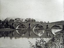
The name Ura Vajgurore translated means oil bridge . The bridge leading over the Osum River and the adjacent settlement used to be called Ura e Hasan Beut . The name Banja , which can be found on some older maps, is derived from a sulphurous healing spring in the river. From bathing in sulfur water one expected healing and blessings for children. During the Ottoman period there was a small market square and an army base near the bridge . The old Ottoman bridge was replaced by a new one under Ahmet Zogu . Oil has been produced in the region since 1928. The oil fields were developed from Ura Vajgurore . In this context, an airfield was created immediately to the east of the town around 1940, from which today's Kuçova military airfield developed. The population increased only slowly: in 1979 2900 people were counted, in 1990 already 4400 people were counted. The eastern Kuçova , which became the center of the Albanian oil industry, developed faster .
Ura Vajgurore lies on the edge of the Myzeqe plain. The place is at the foot of a small hill, the beginning of the southern Albanian mountains. The Osum, which had gradually formed an ever wider valley, emerges from the hill country at this point and flows a few kilometers further north until it unites with the Devoll . Since 2015, a bypass road in the east with a new Osum bridge has been relieving the center of through traffic, especially those to Berat . From the entrance to Berat, a road branches off in Ura Vajgurore to Kuçova, five kilometers away. A few kilometers further west at Poshnja the streets of Lushnja in the northwest (25 kilometers) and of Fier in the west (35 kilometers) come together.
The old community of Ura Vajgurore also included the villages of Bistrovica , Gur i Bardhë , Konisbalta , Pashallia , Vokopola and Skrevan , which are located in the hilly area southwest of Ura Vajgurore . The neighboring Cukalat to the west also included the villages of Allambrez , Krotina , Donofrosa and Slanica . Poshnja and Kutalli lie along the river plains northwest of Ura Vajgurore . The Poshnja municipality consisted of twelve villages (including Çiflik , Arrëz , Syzez , Polizhan , Agim , Kuç and Hinga ), the Kutalli municipality of ten (including Drenovica , Samatica , Rërëz , Goriçan and Malas-Breg ).
Ura Vajgurore lives in particular from agriculture. The Berat region is a traditional wine-growing region . Today there are important wineries in the village , which were among the first private producers in the country after the collapse of the communist regime.
Web links
Individual evidence
- ↑ a b Ines Nurja: Censusi i popullsisë dhe banesave / Population and Housing Census - Berat 2011 . Results Kryesore / Main Results. Ed .: INSTAT . Pjesa / Part 1. Adel Print, Tirana 2013 ( instat.gov.al [PDF; accessed April 14, 2019]).
- ↑ Albturist (Ed.): Guide d'Albanie . Tirana 1958.
- ^ Heinz Gstrein: Walter travel guide to Albania . Walter-Verlag, Olten 1989, ISBN 3-530-29602-3 .
- ↑ James Pettifer: Albania & Kosovo - Blue Guide . A & C Black, London 2001, ISBN 0-7136-5016-8 .
- ↑ Historiku i Kuçovës. In: Bashkia Kuçova. Retrieved August 13, 2019 (Albanian).
- ↑ Michael Schmidt-Neke and Örjan Söberg: Population structure . In: Klaus-Detlev Grothusen (Hrsg.): Albanien (= Südosteuropa-Handbuch ). tape VII . Vandenhoeck & Ruprecht, Göttingen 1993, ISBN 3-525-36207-2 , pp. 464-490 .
- ↑ Çobo Winery. Retrieved March 30, 2014 (English).

