Myzeqe
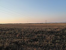
The Myzeqeja plain ( Albanian also Myzeqe ; Aromanian Muzachia ; Italian Musacchia ) occupies large parts of central Albania . The coastal land on the Adriatic was mainly marshland until a few decades ago . After the Second World War , the improvement began . Today the area is mainly used for agriculture.
origin of the name
Before the 13th century the plain was called Savra . From the 13th to the 15th centuries, the plain belonged to the feudal family of the Muzakaj , who gave it its name.
geography
The Myseqeja forms a triangle of approximately 1350 square kilometers between the cities of Vlora in the south and Lushnja in the east and the mouth of the Shkumbin River in the northwest. The river also forms the northern border. In the west the plain is bounded by the Adriatic Sea . In the east the landscape merges into the hills of Dumreja and Mallakastra and the southern Albanian mountains.
The Myzeqeja is largely alluvial land. Beside the Shkumbin, Seman and Vjosa cross the plain. On the coast are lagoons like Karavasta and Narta near Vlora (around 100 square kilometers of the entire area). The surface rarely rises more than 20 meters above sea level. A chain of hills runs through the plain from south to north at a distance of around ten to 20 kilometers from the sea, its highest point is 235 m above sea level. A. The hills of the Myzeqe extend over around 300 square kilometers.
The southernmost part between Vlora and Vjosa is called Myzeqeja e Vlorës . The Little Myzeqeja , also Myzeqeja e Fierit, extends north of it to the Seman . The areas north of the Seman are known as Great Myzeqeja or Myzeqeja e Lushnjës .
history
Antiquity
The founders of the city of Apollonia named the great plain Gylakion pedion after Gylax , who brought the first settlers to this area.
In ancient times the area was not boggy and well suited for agriculture. The region was one of the granaries of the Roman Empire . The grain was exported via the Greek colonies of Apollonia and Dyrrhachion .
The Via Egnatia , the Roman military road that connected the Adriatic with Constantinople , ran through the Myzeqeja plain. The northern route from Durrës followed the Shkumbin, while the southern route from Apollonia ran across the plain.
In late antiquity, the rivers of the Myseqeja changed their course, which among other things led to the siltation of the port of Apollonia. The swamping of the region began.
Middle Ages and Modern Times
With the decline of Byzantine rule in the late Middle Ages, local aristocrats were able to rise to rulers in the Myseqeja. The farmers had to pay high taxes. The rural population lived very primitively in the simplest mud huts. The people suffered from poverty and malaria as around three quarters of the region was marshland and boggy. After the occupation of Albania by the Ottomans , the country became the property of large Muslim landowners .
Only a few small settlements and traffic routes were to be found on the edges of the plain: today's city of Lushnja did not develop until the second half of the 20th century , the small towns of Peqin and Rrogozhina were on the northern edge on the other side of the Shkumbin, the monasteries of Ardenica and Apollonia were on the highest points of the hills. The market town of Fier was the only larger town on the plain. But even there fewer than 2,000 people lived before the swamps were drained.
The wandering Aromanians used the region as winter pasture. They are still resident in some villages in the area today.
20th century and present
While the Italians had drained some swamps in Albania before the Second World War, this work in the Myzeqe was not accelerated until the 1950s . The completion of the improvement took place in the 1970s . The communist Albania had created numerous drainage canals and pumping stations one of the most fertile areas of the country. This was made possible thanks to the support of the Soviet Union , but also through the use of forced labor. Refugees from Kosovo and Çamen , among others, were settled on the new land . But many families of political opponents were also banished here.
The Myzeqe is densely populated today. Places like Fier, Lushnja, Patos and Kuçova became cities where industry also developed. In the southeast of the Myzeqe, oil and natural gas are produced ; Patos and Kuçova are centers of the Albanian oil industry. Roads and railway lines were also built during the communist era.
Malaria has been eradicated in Albania since the swamps were drained .
Floods 2012/13
In the winter of 2012/13 there were extensive floods in many parts of the plain after prolonged rainfall because the canal system was no longer repaired after the end of communism. Also Fier , Berat and Durres were überwschwemmt. Hundreds of buildings and dozens of shops were damaged by the water. Many families were cut off from the outside world for several days. In the cities the sewer system failed and the electricity went out. At Fier the Gjanica overflowed its banks.
Web links
literature
- Eric Fouache, Gjovalin Gruda, Skender Mucaj, Pal Nikolli: Recent geomorphological evolution of the deltas of the rivers Seman and Vjosa, Albania. In: Earth Surface Processes and Landforms. 26, 2001, p. 793, doi : 10.1002 / esp.222 .
Individual evidence
- ↑ Myzeqeja e tëra nën ujë (The whole of Myzeqeja under water). Top Channel , January 20, 2013, accessed January 20, 2013 (Albanian).
- ↑ Përmbytjet, tërhiqen ujërat në Fier, lagje të izoluara në Durrës (the floods, the water withdraws in Fier, cut off quarters in Durrës). Mapo, January 20, 2013, accessed May 5, 2010 (Albanian).
Coordinates: 40 ° 55 ′ 0 ″ N , 19 ° 40 ′ 0 ″ E


