Narta Lagoon
| Narta Lagoon | |
|---|---|

|
|
| The island of Zvërnec | |
| Geographical location | Albania |
| Islands | Island of Zvërnec , Ishull i Karakonjishtit |
| Places on the shore | Zvërnec , Narta |
| Location close to the shore | Vlora |
| Data | |
| Coordinates | 40 ° 32 ′ 0 ″ N , 19 ° 25 ′ 0 ″ E |
| surface | 45 km² |
| length | 9.5 km |
| width | 6 km |
| Maximum depth | 2.1 m |
| Middle deep | 1.3 m |
|
particularities |
Saline in the northern part |

|
|
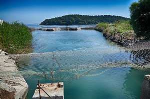
| Southern Canal near Zvërnec: View of the lagoon | |
The lagoon of Narta ( Albanian Laguna e Nartës ) is a lagoon on the Albanian Adriatic coast northwest of Vlora .
At the southwest end of the lagoon is the village of Zvërnec , at the southeast the village of Narta , which gave it its name.
The area is part of the 194 square kilometer Vjosa-Narta protected landscape area .
geography
The approximately 45 square kilometers large lagoon is located at the southern end of the Myzeqe plain. A mostly narrow strip of sand in the northwest separates the lagoon from the sea. In the south-western area it is partly slightly hilly - here the spit drops in some places in cliffs to the sea, which merges into the bay of Vlora in the south . Sand dunes can be found in the west and northwest . A small area of it has been declared a natural monument. At Cape Daljan there is a swampy wetland with a small lagoon lake on the strip of land.
The lagoon on the flat coast was formed by deposits that the Vjosa River carries a few kilometers north into the sea at its mouth. The exchange of water with the sea is poor, the connecting channels often silt up , so that large areas often fall dry in summer.
Two narrow channels of 200 and 800 meters in length connect the lagoon with the sea. At Zvërnec there are two small islands, which together have an area of around seven hectares. The smaller Ishull i Karakonjishtit ( 14 m above sea level ) has only sparse vegetation. The larger Ishull i Zvërnecit ( 31 m above sea level ) is forested with mighty cypress trees . It has a length of 340 meters, a width of almost 300 meters and is around 250 meters from the shore and is accessed via a wooden walkway. An Orthodox monastery was founded on the island of Zvërnec in the 13th century . The small St. Mary's Church from the 13th or 14th century is still preserved .
use
Mussels and fish are caught in the lagoon .
The northern third of the lagoon (15 square kilometers) is separated from the rest by a dam and is used as a salt works ( Albanian kripora e Skrofotinës ). The salinity of the water in the lagoon reaches up to 7%.
“A natural paradise similar to the Camargue in southern France is the lagoon of Narta, north of the coastal city of Vlora. Salt is extracted there in the traditional way, and the sea also supplies the fresh fish that is served on the coast. "
The Albanian government is planning to build an airport for Vlora just north of the lagoon .
Wildlife
There are 32 different species of molluscs , octopus , Mediterranean sea crab ( Carcinus mediterraneus ) and mussels in the lagoon . Common fish species are eel , Mittelmeerkärpfling ( Aphanius spp.), Small and Mediterranean sand smelt , Thicklip and thinlip mullet , jumping mullet , Flathead Gray Mullet , European and spotted seabass , striped bream , SARGO , two-banded bream , Guppy , bream , fire bream , sea bream , nail skate and sole .
The Narta Lagoon is one of the most important wetlands and wintering areas for waterfowl in Albania. Ducks and coots are particularly common . In the lagoon wintering Dalmatian pelican , flamingos , pintails , goldeneye , snowy plover , coral gulls , Slender-billed curlew , gray plover and shelduck .
Web links
Individual evidence
- ↑ a b Niko Pano: Fjalor enciklopedik shqiptar . Ed .: Akademia e Shkencave e RPSSH. Tirana 1985, keyword Laguna e Nartës , p. 592 .
- ↑ a b c d e f Aleko Miho, Lefter Kashta, Sajmir Beqiraj: Between the Land and the Sea. Ecoguide to discover the transitional waters of Albania . Ed .: University of Tirana. Julvin 2, Tirana 2013, ISBN 978-9928-13727-2 , pp. 306-311 .
- ↑ a b Peisazhi i mbrojtur "Vjosë-Nartë". (PDF) In: infrastructurea.gov.al. Retrieved April 19, 2020 (Albanian).
- ↑ a b c Niko Pano: Pasuritë ujore të Shqipërisë . Akademia e Shkencave e Shqipërisë , Tirana 2008, ISBN 978-99956-10-23-4 , pp. 326-329 .
- ↑ Official map 1: 50,000 of the military cartographic office of Albania, sheet K-34-123-B Novosela, 3rd edition 1990.
- ↑ Andreas Lippert: Zvernec . In: Christian Zindel, Andreas Lippert, Bashkim Lahi, Machiel Kiel (eds.): Albania. An archeology and art guide from the Stone Age to the 19th century . Böhlau, Vienna 2018, ISBN 978-3-205-20723-8 , pp. 352 f .
- ↑ a b c Aleko Miho, Lefter Kashta, Sajmir Beqiraj: Between the Land and the Sea. Ecoguide to discover the transitional waters of Albania . Ed .: University of Tirana. Julvin 2, Tirana 2013, ISBN 978-9928-13727-2 , pp. 337-347 .
- ↑ Martin Winkel: Visiting Albania . In: Coop newspaper . No. 23 , June 2, 2020, p. 27 f .

