Usu (volcano)
| Usu | ||
|---|---|---|
|
The Usu |
||
| height | 733 m TP | |
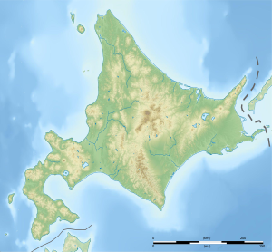
| location | Hokkaido Prefecture , Japan | |
| Coordinates | 42 ° 32 '33 " N , 140 ° 49' 57" E | |
|
|
||
| Type | active stratovolcano | |
| Last eruption | 2000 | |
|
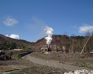
Tōyako Onsen in front of the Meiji-Shinzan crypto dome built in 1910 |
||
|
Area of the 2000 eruptions (2001 image) |
||
The Usu ( Japanese 有 珠 山 , Usu-zan ) is a stratovolcano on the island of Hokkaidō in northern Japan . During the eruptions of the Usu, lava and crypto domes formed several times .
construction
The Usu is located on the southern edge of the Tōya caldera , which is 10 kilometers in diameter and formed around 110,000 years ago. In the present day, large parts of the caldera are occupied by Lake Tōya . After the formation of the caldera, eruptions of basalt and andesite created a stratovolcano, also known as Uso Somma based on Vesuvius . A violent eruption about 7000 to 8000 years ago destroyed the summit of Uso Somma . This caused a debris avalanche , the deposits of which can be found south-southwest of the volcano on the coast of the Pacific Ocean . The eruption left a crater two kilometers in diameter. Later eruptions largely filled the crater with lava and cryptodomes. The domes are made of dacite , a particularly viscous type of magma .
outbreaks
Between 1663 and 1853 there were four Plinian eruptions with strengths from four to five on the volcanic explosive index (VEI). During this time, the Ogari-yama crypto dome and the Ko-Usu and O-Usu lava domes were built in the crater , at 733 meters the highest point of the volcano. The village of Abuta was destroyed in an eruption in May 1822 . 50 people died and 53 were injured.
The outbreak from July 25, 1910 was preceded by earthquakes for six days . At the same time, cracks and faults formed at the northwest foot of the Usu . By early August, phreatic explosions from small, newly formed craters occurred . A new cryptodome, the Meiji Shinzan ( 42 ° 34 ′ N , 140 ° 50 ′ E ), was built on the shores of Lake Tōya . By November 1910 it arched up to 160 meters. Shortly after the eruption, the first hot springs appeared southwest of Lake Tōya. In 1919 a hotel was built at a spring. It paved the way for the popular spa town of Tōyako Onsen to emerge .
At the end of 1943, a series of earthquakes began, the epicentres of which shifted six kilometers from the north-east to the east side of the Usu as the focal depth decreased. From February or March 1944, another cryptodome, the Showa-Shinzan ( 42 ° 33 ′ N , 140 ° 52 ′ E ) , formed around two kilometers east of the Usu crater . It dammed a river and broke through the surface of the earth in early November 1944, turning it into a lava dome. Its growth stopped in September 1945 after lifting over 200 meters. Probably due to the cooling of the magma, the cathedral sank by 25 meters between 1945 and 1968. From June 1944 onwards, the cathedral's growth was accompanied by eruptions, initially phreatic and later phreatomagmatic explosions .
Scientists initially paid little attention to the outbreak in the final phase of World War II. Mimatsu Masao, a postal worker from Tōyako, recorded the growth of the cathedral in detail in pictures and reports. The result - according to the geologist Hans Pichler - "an excellent volcanological work by a layman". Mimatsu Masao is remembered by a museum and a memorial on the Usu.
An eruption on August 7, 1977 forced the evacuation of 20,000 tourists and 7,000 residents. During the eruption, a column of eruption at least ten kilometers high rose; Ash fell on large parts of the island of Hokkaido. Accompanied by weaker eruptions, another cryptodome bulged up to 180 meters in the central crater. The northern rim of the crater shifted by a similar amount. This caused faults and cracks in Tōyako Onsen that damaged or destroyed houses and supply lines. In November 1978, a mud flow called a lahar caused further damage to houses in Tōyako Onsen . Three people died in the process.
On March 31, 2000, there was a flank eruption in the northwest of the Usu. The contact between a groundwater horizon fed by Lake Tōya and rising magma triggered severe phreatomagmatic eruptions. More than 50 new craters had formed by mid-April. In the same month, lahars formed which caused damage in Tōyako Onsen and spilled into Lake Toya. The northwest of the Usu rose up to 3.3 meters per day. The weakening eruptions ended in early May 2000. A day before the March 31 eruption, 10,000 people had been evacuated.
Web links
- Usu in the Global Volcanism Program of the Smithsonian Institution (English)
- Usu in the Japanese Volcanoes Quaternary database (English and Japanese)
- Usu outbreak in 2000 (English)
Individual evidence
- ^ Christopher G. Newhall, Daniel Dzurisin: Historical unrest at large calderas of the world . USGS Bulletin 1855, 1988 (English, pdf, 37.0 MB), p. 527.
- ^ Eruptive History in the Global Volcanism Program (accessed March 17, 2013).
- ↑ Usu in the Japanese Volcanoes Quaternary database (English and Japanese, accessed August 31, 2016).
- ↑ Usu 1822 in The Significant Volcanic Eruption Database of NOAA (English, accessed on March 17, 2013).
- ↑ Newhall, Dzurisin, Historical unrest , S. 528f.
- ↑ Newhall, Dzurisin, Historical unrest , S. 529f.
- ^ A b Hans Pichler: volcanic areas of the earth. Elsevier, Munich 2007, ISBN 978-3-8274-1475-5 , p. 192.
- ↑ Monthly reports 08 / 1977-12 / 1983 in the Global Volcanism Program (English, accessed on March 17, 2013).


