Valamara
| Valamara
Maja e Valamarës
|
||
|---|---|---|
|
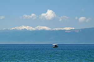
Valamara and the surrounding mountains seen from Ohrid from a distance of around 45 kilometers |
||
| height | 2373 m above sea level A. | |
| location | Southeast Albania , Central Mountain Country | |
| Mountains | Western border chain of Inner Albania | |
| Dominance | 28.5 km → Tomorr | |
| Notch height | 1526 m | |
| Coordinates | 40 ° 47 '38 " N , 20 ° 27' 55" E | |
|
|
||
| rock | Ultrabasic rock or serpentinite | |
| Normal way | From Grabova e Sipërme over the south ridge | |
The Valamara ( Albanian also Mali i Valamarës ) is a mountain in southeast Albania . The peak of Maja e Valamarës is 2373 m above sea level. A. the highest point between the valleys of the Shkumbin in the north and the Devoll in the south. The Valamara is located in a remote mountain area on the border between the regions of Gramsh , Pogradec and Korça . With a notch height of 1526 meters, it is one of the most prominent mountains in Europe.
The Valamara mountain range is part of a series of mountains that stretch north to south between the Shkumbin and Devoll valleys. The northern neighbor of the Valamara is the Gur i Topit ( 2120 m above sea level ), in the south follows the Mal i Lenies ( 2012 m above sea level ). The Shkumbin rises on the east side . The west and south flanks are drained towards the Devoll, which has formed a deep gorge through the mountains. To the east of the mountain lies the Gora Mountains .
The Valamara runs as a steep ridge in a north-south direction. The mountain is around 13 kilometers long and up to ten kilometers wide. The terrain has clear glacial forms that reach an altitude of up to 1500 m above sea level. A. can be found. There are several glacial lakes on the east side .
In the lower elevations there are extensive forests, in the lower elevations the oak used to dominate , over 1300 meters the beech . At the tree line around 2000 m above sea level. A. There were also fir trees . In the northeast, a large area is protected as the Gur i Nikës resource reserve. The region around the mountain is almost uninhabited. The closest village is Grabova e Sipërme on the western slope (approx. 1250 m above sea level ).
Web links
- Palm Tree Production - Report an ascent (English)
- Petter Bjorstad - Report an ascent (English)
- Winter summit views on YouTube
Individual evidence
- ↑ a b Akademia e Shkencave e RPSSH (ed.): Fjalor enciklopedik shqiptar . Tirana 1985, Valamara, p. 1150 .
- ↑ a b Herbert Louis : Albania. A study of the country mainly because of my own travels . Published by J. Engelhorn's successors in Stuttgart, Berlin 1927, p. 118 .
- ↑ Europe Ultra-Prominences. In: peaklist.org. Accessed December 23, 2015 .
- ↑ a b Mevlan Kabos et al .: Gjeografia fizike e Shqipërisë . Ed .: Akademia e Shkencave e RPS të Shqipërisë. tape 2 . Tirana 1991, Malet midis luginës së Shkumbinit dhe luginës së Devollit, p. 253 f .
- ↑ Mevlan Kabos et al .: Gjeografia fizike e Shqipërisë . Ed .: Akademia e Shkencave e RPS të Shqipërisë. tape 1 . Tirana 1990, p. 237 f .


