
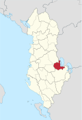
Pogradec district
  |
|
| Circle : | Pogradec |
| Main place: | Pogradec |
| Qark : | Korça district |
| Surface: | 725 km² |
| Residents: | 61,530 as of 2011 |
|
Population density: |
84.87 inhabitants / km² |
| ISO-3166-2 code: | AL-PG |
| License plate : | PG |
The Pogradec district ( Albanian Rrethi i Pogradecit ) was one of the 36 administrative districts of Albania that were abolished in the summer of 2015 after an administrative reform. The area with an area of 725 square kilometers is located in the east of the country and belongs to the Qark Korça . It was named after the capital Pogradec .
Today the area of the district forms the municipality of Pogradec .
population
In 2011 the district had 61,530 inhabitants. Around ten percent belong to the Macedonian and Aromanian minorities. More than half of the population belong to the Muslim faith ( Sunnis and Bektashi ), the rest are Orthodox or have no creed.
geography


The Pogradec district occupies the approximately 30 km long Albanian shore of Lake Ohrid , which Albania shares with North Macedonia . At the southern end of the lake is Pogradec, behind which there is a small plain, where the population has risen sharply in recent decades. The municipality of Buçimas surrounding Pogradec had 13,546 inhabitants (2011). To the north and east of this plain, handsome mountains surround the lake, which is 695 m above sea level. A. lies. The mountains regularly reach heights of 1500 meters, in the southeast the Mali i Thatë rises even to 2287 m above sea level. A. The boundaries of the circle were usually already on the ridges of the mountains surrounding the lake. Only west of Pogradec the area also encompassed the next valley, the widely ramified upper reaches of the Shkumbin . The mountains between Shkumbin and the lake are called Mokra Mountains , to the south the Gora Mountains adjoin . In the very south-west is the highest point of the former district, 2373 m above sea level. A. high Mali e Valamarës .
During communist times, nickel , lignite and chromium were mined in numerous places in Pogradec County . The Gur i kuq (Red Stone) mine three kilometers north of Pogradec, one of the most important iron-nickel deposits in Europe, was of particular importance. Work in the mine stopped in 1994. The production facilities were no longer profitable after the opening of Albania to the international market. What remained are 350,000 tons of spoil heaps, the industrial ruins on the mountainside and the former rail loading station for the processed ore directly on the lake shore. The ecosystem is still suffering from the heavy metal waste water discharged into the lake .
The degradation of the environment is a big issue in Pogradec. International projects are trying to curb the pollution of the lake by building sewage treatment plants. The overfishing is a problem. The endemic Ohrid trout ( Salmo letnica , Albanian Koran ), a popular food fish, is threatened.
history
Remains from Roman times have been found in the village of Lin , on the Roman highway Via Egnatia . The name Pogradec goes back to a Serbian castle . The Illyrians had already built a fortress at the same place . Another attraction from the Illyrian era are the royal tombs of Selca e Poshtme from the 4th century BC in the Shkumbintal. Not far from there is the Golik Bridge , a bridge built by the Ottomans in the 17th century over the Shkumbin River.
In 1924 the Pogradec district and Albania lost a small piece of land. Ahmet Zogu , then Prime Minister of Albania, left the monastery Sveti Naum ( Albanian Shën Naum ) located directly on the border to Yugoslavia . He had previously received money from the government in Belgrade to finance a mercenary force with whose help he drove his political opponents from the capital Tirana and took power in the country.
economy

Pogradec has long been a seaside resort. The Eastern Albania's climate, which was not quite so hot in summer, was particularly popular with the communist rulers. To the east of Pogradec, an entire stretch of beach was reserved for the Enver Hoxha nomenklatura .
The summer tourism lives gradually again. Several hotels and restaurants have sprung up along the lake shore, especially in the small town of Tushemisht , five kilometers from Pogradec on the North Macedonian border.
traffic
To the mine Gur i Kuq a railway line was built in the communist era, the circle of Shkumbin Valley of second-longest by Albania tunnel reached. The Albanian railways HSH no longer operate the route. The train station in Gur i kuq was a few kilometers outside of Pogradec.
The road ( SH 3 ) from Elbasan in central Albania over the Qafë Thana pass on the district border west of Lin to Pogradec is well developed. Thanks to the two border crossings to North Macedonia near Lin and Tushemisht east of Pogradec, the region is also very well connected with other countries.
Communities
The area of the district is now the municipality ( bashkia ) Pogradec.
| Surname | Population (2011) | Community type |
|---|---|---|
| Pogradec | 20,848 | Bashkia |
| Buçimas | 15,687 | Komuna |
| Çërrava | 7.009 | Komuna |
| Dardhas | 2,182 | Komuna |
| Hudenisht | 5,990 | Komuna |
| Proptisht | 4,785 | Komuna |
| Trebinja | 2,481 | Komuna |
| Velçan | 2,548 | Komuna |
Web links
- Pogradec Guide (English and Albanian)
swell
- ↑ a b c Ines Nurja: Censusi i popullsisë dhe banesave / Population and Housing Census - Korçë 2011 . Results Kryesore / Main Results. Ed .: INSTAT . Pjesa / Part 1. Adel Print, Tirana 2013 ( instat.gov.al [PDF; accessed April 14, 2019]).
- ^ Directorate for Development and Cooperation (Tirana Office): Success Story Lake Ohrid: Water Supply and Environmental Protection. Retrieved February 3, 2010 .
- ↑ Mevlan Kabos et al .: Gjeografia fizike e Shqipërisë . Ed .: Akademia e Shkencave e RPS të Shqipërisë. tape 2 . Tirana 1991.
- ↑ Lirim Selfo, Arian Merolli, Sandri Kycyku: Environmental situation of Lake Ohrid and its trends. (PDF) November 16, 2004, accessed on December 29, 2015 (English).

Berat | Bulqiza | Delvina | Devoll | Dibra | Durrës | Elbasan | Fier | Gjirokastra | Gramsh | Has | Kavaja | Kolonja | Korça | Kruja | Kuçova | Kukës | Kurbin | Lezha | Librazhd | Lushnja | Malësia e Madhe | Mallakastra | Mat | Mirdita | Peqin | Përmet | Pogradec | Puka | Saranda | Shkodra | Skrapar | Tepelena | Tirana | Tropoja | Vlora