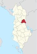
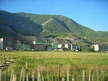
Bulqiza district
| Circle : | Bulqiza |
| Main place: | Bulqiza |
| Qark : | Qark Dibra |
| Surface: | 718 km² |
| Residents: | 31,210 as of 2011 |
|
Population density: |
43.47 inhabitants / km² |
| ISO-3166-2 code: | AL-BU |
| License plate : | BZ |
The district of Bulqiza ( Albanian : Rrethi i Bulqizës ) was one of the 36 administrative districts of Albania that were abolished in the summer of 2015 after an administrative reform. The district with an area of 718 square kilometers belonged to Qark Dibra and had 31,210 inhabitants (2011). The district was named after the main town Bulqiza .
Today the area forms the municipality of Bulqiza .
geography
The area of the district essentially consisted of two left side valleys of the Drin southwest of the Dibra region . In the east it borders on North Macedonia ; in parts the border is formed by the Drin. In this area, called Golloborda, there are also some villages inhabited by Macedonians .
The landscape is mostly mountainous. From the Drin bank to about 450 m above sea level. A. the mountains rise to over 2000 m above sea level. A. at. Most of the residents live in the Drin Valley and in the mining town of Bulqiza.
In an earlier territorial reform, the municipality of Martanesh with the mining town of Krasta at the southern end of the Mat valley was assigned to the Bulqiza district. Martanesh , where the river Mat has its source, is famous for its red goat species . On the other hand, the municipality of Stërbleva , formerly the southernmost municipality in the district, was assigned to the Librazhd district.
population
Macedonians made up around five to ten percent of the population. More than half of the residents profess to be part of the Bektashi Muslim community .
economy
Nickel is still being mined in the Bulqiza and Krasta mines . The Bulqiza mine is said to be the largest in the country, but it only employs a fraction of the workforce during the communist era . In the other places the inhabitants live almost exclusively from agriculture .
Bulqiza and some villages in the north of the district are on the thoroughfare from the coastal plain to Peshkopia . The remaining areas, however, are very remote and difficult to reach. In winter, many roads are snowy and impassable. The SH6 national road , which crosses the Qafa e Buallit pass ( 837 m above sea level ) a few kilometers west of Bulqiza , is also repeatedly impassable. The Rruga e Arbërit , which is currently under construction, will better connect the region with the centers of Albania.
Communities
| Surname | Population (2011) | Community type |
|---|---|---|
| Bulqiza | 8,177 | Bashkia |
| Fushë Bulqiza | 3,342 | Komuna |
| Gjorica | 4.214 | Komuna |
| Martanesh | 1,836 | Komuna |
| East | 3,034 | Komuna |
| Shupenza | 5,503 | Komuna |
| Trebisht | 993 | Komuna |
| Zerqan | 4.111 | Komuna |
Individual evidence
- ↑ a b Ines Nurja: Censusi i popullsisë dhe banesave / Population and Housing Census - Dibër 2011 . Results Kryesore / Main Results. Ed .: INSTAT . Pjesa / Part 1. Adel Print, Tirana 2013 ( instat.gov.al [PDF; accessed April 14, 2019]).


