
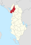
Shkodra County
  |
|
| Circle : | Shkodra |
| Main place: | Shkodra |
| Qark : | Qark Shkodra |
| Surface: | 1631 km² |
| Residents: | 166.050 As of 2011 |
|
Population density: |
101.81 inhabitants / km² |
| ISO-3166-2 code: | AL-SH |
| License plate : | SH |
The Shkodra District ( Albanian : Rrethi i Shkodrës ) was one of the 36 administrative districts of Albania that were abolished in the summer of 2015 after an administrative reform. With an area of 1631 square kilometers, it was the second largest district in the country. The area is located in northern Albania and belongs to the Qark of the same name . The district was named after the capital Shkodra . The population was 166,050 (2011 census). The local authorities, however, spoke of 248,480 inhabitants.
geography

Due to the size, the nature of the area is extremely diverse. It can be divided into two main areas: The coastal plain stretches from the beaches of the Adriatic Sea in the south to behind Shkodra. The rest is mountainous country that begins with hills and extends to the highest peaks of the Albanian Alps in the north. extends. In the west lies Montenegro .
Waters

In addition to the Adriatic Sea in the southwest, other bodies of water formed the boundary of the district in parts: Lake Shkodra lies in the northeast . The Buna , which connects the lake with the sea, forms the border of the district with Montenegro for part of its course . The Drin, in turn, dammed up to Lake Koman and Liqen i Vaut të Dejës , is the border in the southeast. The two tributaries of the Drin on the right, Kir and Shala , drain the northern part of the district.
level
_in_Shkodra.JPG)
The southwest is a large alluvial plain , which is crossed by the Drin and Buna. The plain begins at Lezha and stretches along the eastern bank of the shallow Lake Shkodra to the Montenegrin border. But even this flat coastal strip is repeatedly interrupted by elevations. Two stately hills almost 400 meters high run parallel to the coast from Lezha to Velipoja . Mount Tarabosh ( 594 m above sea level ) rises on the south-west bank of Lake Shkodra . The local center in the area south of Shkodra is the village Bushat on the edge of the Zadrima plain, until 2015 an independent municipality with 14,149 inhabitants.
The banks of the Buna and Shkodrasse and the wetlands around Velipoja are important nature reserves. Many migratory and water birds stay here.
Albanian Alps


The area of the district included those parts of the western Alps that are drained to the Drin (in contrast to Malësia e Madhe , which is drained to Lake Shkodra). In particular, these are the valleys of the Kir and Shala. The extreme north of the district is high mountains . With increasing distance to the sea and the coastal plain, the landscape quickly rises to stately heights. Less than 20 kilometers northeast of Shkodra is the Maranaj at 1576 m above sea level. A. Behind is the Pult region , a remote mountain valley. Various peaks south of it almost reach the height of the Maranaj, the Maja e Cukalit 30 kilometers east of Shkodra in the Cukali highlands even comes to 1723 m above sea level. A. Further north around the upper reaches of the Shala River, the Theth Valley, various two-thousand-meter peaks gather. In the far north lies the Jezerca ( 2694 m above sea level ), the highest mountain in the Albanian Alps.
At Theth, an area of 23.3 square kilometers is protected as Theth National Park. The trough valley forms a unique high mountain landscape with several waterfalls ( Grunas waterfall and Gjeçaj waterfall ). The park provides a retreat for lynx and other wildlife.
population

The region's population is as diverse as the landscape. The contrasts between the Shkodran urban population, whose city was long the largest and most important in the country, and the rural population from the plains and high mountains are and always have been very great. The mountains of Shkodra belong to an area that was formerly inhabited by very independent Albanian tribes. The administration of the Ottoman Empire was never able to gain a foothold in this remote mountain world, but the Albanian state also had and still has difficulties in being recognized by the mountain people. Archaic customs, the custom of the Kanun and blood revenge are still part of the way of life, especially in the mountains of Northern Albania. The strong rural exodus since the collapse of communism has led many people from the mountains to the suburbs of Shkodra. The community of Rrethina , which surrounded the center of Shkodra until 2015, had grown to 21,199 inhabitants in 2011, around a third of the population of Bashkia Shkodra . The long-established Shkodrans complain that many immigrants find it difficult to adapt to urban customs.
In Shkodra, however, religions also clashed, as the Catholic population of Albania was centered in and around the city . Around two thirds of the residents are Catholic. Around a quarter are Muslim and a minority Orthodox .
While the city with its immediate surroundings was long characterized by different nationalities - in addition to the Albanians , Ottomans and Slavs - the population is very homogeneous today. About 1000 Montenegrins live in villages in the vicinity of Shkodra. A large number of Roma live in the city and on its outskirts.
history

The history of the region is of course shaped by that of the city. The Rozafa castle hill was fortified by the Illyrians . The castle and its changing rulers have determined the fortunes of the city until modern times.
There are also some places outside the city that also had historical significance, but which have not yet been adequately explored. Drisht Castle , located not far from the Mes bridge on a hill east of Shkodra, is possibly one of the oldest settlements in Albania. And along the Buna there were various small towns (Reç, Dajç) and churches ( monastery of Shirgj ) in the pre-Ottoman period .
On April 15, 1979, an earthquake with an epicenter near Ulcinj and a magnitude of 7.2 points on the Richter scale struck Montenegro and northern Albania. There were 35 deaths to mourn. In particular around Shkodra, many houses were damaged or destroyed. The people's republic managed the reconstruction without foreign help. In Shkodra, after the one in 1905, it was the second strong earthquake in the 20th century.
In January 2010 the whole plain from Velipoja to the mountains was flooded after it had rained heavily and for a long time and the relief sluices at the dams on the Drin had to be opened. Thousands of people had to be evacuated. In Shkodra, too, the water was in the streets.
economy

In northern Albania, the economic situation during the transition period was more difficult than in most other regions of Albania. The unrest and lawlessness, which was more widespread in the north, did little to help. Large areas in the mountains are still completely cut off from any progress.
In Velipoja, a rapidly growing tourist infrastructure emerged in the first years of the 21st century . The beach is popular with Albanians from the region and Kosovo . In Theth, too, a flourishing hiking tourism developed with small hotels and numerous rooms in private accommodation. The villages of Shiroka and Zogaj on the western shore of the lake are excursion destinations not far from Shkodra.
The hydropower plants in Koman and Vau-Deja are important for the whole country . The Austrian electricity company Verbund built a smaller power plant on the lower reaches of the Drin near Ashta .
traffic

Thanks to the construction of the northern section of the North / South Corridor ( SH1 ), Shkodra is now well connected to the centers of the country by road. The road has also been continuously expanded further north via the border town of Han i Hotit into neighboring Montenegro. At the end of the 1990s, another border crossing was opened between Shkodra and Ulcinj, which simplified the exchange with the neighboring country and the Albanian minority in Montenegro.
The city is also connected to the Hekurudha Shqiptare railway network: the only international connection is via Shkodra to Podgorica in Montenegro. However, the importance of rail transport is still very minor. Plans to start passenger transport between the two countries have not yet been implemented.
The mountain regions are very difficult to reach. The few roads are hardly passable without a four-wheel drive vehicle. In addition, there is meter-high snow in winter, so that numerous villages cannot be reached for months. There are no roads at all in the region along the Koman Reservoir . The residents use boats on the lake when they want to leave their villages. On the reservoir between Koman and Fierza there is a car ferry and other smaller ferry boats in summer .
Communities
| Surname | Population (2011) | Community type | Heard today |
|---|---|---|---|
| Shkodra | 77,075 | Bashkia | Shkodra |
| Vau-Deja | 8,117 | Bashkia | Vau-Deja |
| Ana e Malit | 3,858 | Komuna | Shkodra |
| Bërdica | 5,773 | Komuna | Shkodra |
| Bushat | 14,149 | Komuna | Vau-Deja |
| Dajç | 3,885 | Komuna | Shkodra |
| Gur i Zi | 8,085 | Komuna | Shkodra |
| Hajmel | 4,430 | Komuna | Vau-Deja |
| Postriba | 7,069 | Komuna | Shkodra |
| teacher's desk | 1,529 | Komuna | Shkodra |
| Rrethina | 21.199 | Komuna | Shkodra |
| Shala | 1,804 | Komuna | Shkodra |
| Shllak | 671 | Komuna | Vau-Deja |
| Shosh | 304 | Komuna | Shkodra |
| Temal | 1,562 | Komuna | Vau-Deja |
| Velipoja | 5,031 | Komuna | Shkodra |
| Vig-Mnela | 1,509 | Komuna | Vau-Deja |
literature
- Monica Genesin, Joachim Mathinger (Ed.): Northern Albania - L'Albania del Nord: Linguistic-cultural-historical explorations in an unknown part of Europe / Contributi linguistici e culturali su un'area sconosciuta dell'Europa , Orbis series of publications - Scientific writings on regional studies , volume 15, Verlag Dr. Kovač, Hamburg 2009, ISBN 978-3-8300-3555-8
Individual evidence
- ↑ a b c d Ines Nurja: Censusi i popullsisë dhe banesave / Population and Housing Census - Shkodër 2011 . Results Kryesore / Main Results. Ed .: INSTAT . Pjesa / Part 1. Adel Print, Tirana 2013 ( instat.gov.al [PDF; accessed April 14, 2019]).
- ↑ qarkushkoder.org. Retrieved January 13, 2009 .
- ↑ NZZ Online from January 8, 2010: Thousands homeless because of floods in Albania. Retrieved January 19, 2010 .
- ↑ The Press, January 12, 2010: Albania: Floods put prime minister under pressure. Retrieved January 19, 2010 .

Berat | Bulqiza | Delvina | Devoll | Dibra | Durrës | Elbasan | Fier | Gjirokastra | Gramsh | Has | Kavaja | Kolonja | Korça | Kruja | Kuçova | Kukës | Kurbin | Lezha | Librazhd | Lushnja | Malësia e Madhe | Mallakastra | Mat | Mirdita | Peqin | Përmet | Pogradec | Puka | Saranda | Shkodra | Skrapar | Tepelena | Tirana | Tropoja | Vlora