
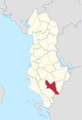
Përmet district
  |
|
| Circle : | Përmet |
| Main place: | Përmet |
| Qark : | Gjirokastra Qark |
| Surface: | 929 km² |
| Residents: | 16,727 as of 2011 |
|
Population density: |
18 inhabitants / km² |
| ISO-3166-2 code: | AL-PR |
| License plate : | PR |


The Përmet district ( Albanian : Rrethi i Përmetit ) was one of the 36 administrative districts of Albania that were abolished in the summer of 2015 after an administrative reform. The area with an area of 929 square kilometers is located in the south of the country and belongs to the Gjirokastra Qark . The district was named after the capital Përmet .
Not quite half of the population of 16,727 inhabitants (2011) belong to the Greek or the Aromanian minority. In the post-communist period, the Orthodox and Muslim faith experienced a resurgence. Around half of all Muslims are Bektashi . Recently, Protestantism has also appeared in Përmet .
The Përmet region encompasses the Vjosa valley from the Greek border to the Këlcyra gorge and some side valleys. The river valley is surrounded by high mountains. In the west, the mountain range at Nemërçka , which runs parallel to the river and slopes steeply to the east, reaches a height of 2,484 m above sea level. A. , in Mali i Dhëmbel 2090 m above sea level. A. In the east the mountains rarely reach heights above 1500 m A. But the region is very remote and inaccessible. A substantial part of the mountainous and forested east of the district belongs to the 34,361 hectare Hotova-Dangell National Park . The Lengarica formed an extremely narrow gorge when a mountain breakthrough .
The Vjosa mountain valley is very secluded and is best reached via Tepelena . A road leads over Erseka through the highlands from Kolonja to Korça . A border crossing in the south makes it possible to cross the border with Greece, which has been hermetically sealed for around 45 years.
Përmet is traditionally known for its wine and its raki , one made of fermented grape brandy , the best is yet house burned. Famous throughout Albania is the village of Frashër , the hometown of the brothers Abdly , Naim and Sami Frashëri , who fought for the independence of Albania. Architectural attractions in the district include some old Orthodox churches; that of Leusa dates from the 17th century.
The area of the district has been divided into the municipalities ( bashkia ) Përmet and Këlcyra since 2015 .
| local community | Community type | Population (2011) | New to Bashkia |
|---|---|---|---|
| Ballaban | Komuna | 1,047 | Këlcyra |
| Çarçova | Komuna | 918 | Përmet |
| Dishnica | Komuna | 1,159 | Këlcyra |
| Frashër | Komuna | 387 | Përmet |
| Këlcyra | Bashkia | 2,651 | Këlcyra |
| Përmet | Bashkia | 5,945 | Përmet |
| Petran | Komuna | 1,622 | Përmet |
| Qendër Piskova | Komuna | 1,742 | Përmet |
| Suka | Komuna | 1,256 | Këlcyra |
Individual evidence
- ↑ a b Ines Nurja: Censusi i popullsisë dhe banesave / Population and Housing Census - Gjirokastër 2011 . Results Kryesore / Main Results. Ed .: INSTAT . Pjesa / Part 1. Adel Print, Tirana 2013 ( instat.gov.al [PDF; accessed April 14, 2019]).

Berat | Bulqiza | Delvina | Devoll | Dibra | Durrës | Elbasan | Fier | Gjirokastra | Gramsh | Has | Kavaja | Kolonja | Korça | Kruja | Kuçova | Kukës | Kurbin | Lezha | Librazhd | Lushnja | Malësia e Madhe | Mallakastra | Mat | Mirdita | Peqin | Përmet | Pogradec | Puka | Saranda | Shkodra | Skrapar | Tepelena | Tirana | Tropoja | Vlora