
Malësia e Madhe district
  |
|
| Circle : | Malësia e Madhe |
| Main place: | Koplik |
| Qark : | Qark Shkodra |
| Surface: | 897 km² |
| Residents: | 30,823 as of 2011 |
|
Population density: |
34.37 inhabitants / km² |
| ISO-3166-2 code: | AL-MM |
| License plate : | MA |
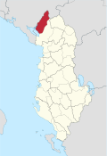
The Malësia e Madhe district (Albanian: Rrethi i Malësisë së Madhe ) was one of the 36 administrative districts of Albania that were abolished in the summer of 2015 following administrative reform. The area of the district with an area of 897 square kilometers in Shkodra Qark today forms the municipality of Malësia e Madhe . The district comprised central areas of Malësia e Madhe in the plain east of Lake Shkodra and in the Albanian Alps . The main town was the small town of Koplik . As the northernmost district of Albania, it bordered Montenegro in the north .

The district had 30,823 inhabitants in 2011 (2011 census). The local authorities, however, gave a number of 54,522 inhabitants.
| Surname | Residents | Community type |
|---|---|---|
| Koplik | 3,734 | Bashkia |
| Gruemira | 8,890 | Komuna |
| Castrato | 6,883 | Komuna |
| Kelmend | 3,056 | Komuna |
| Qendër Koplik | 4,740 | Komuna |
| Shkrel | 3,520 | Komuna |
Individual evidence
- ↑ a b Ines Nurja: Censusi i popullsisë dhe banesave / Population and Housing Census - Shkodër 2011 . Results Kryesore / Main Results. Ed .: INSTAT . Pjesa / Part 1. Adel Print, Tirana 2013 ( instat.gov.al [PDF; accessed April 14, 2019]).
- ↑ qarkushkoder.org. Retrieved January 13, 2009 .

Berat | Bulqiza | Delvina | Devoll | Dibra | Durrës | Elbasan | Fier | Gjirokastra | Gramsh | Has | Kavaja | Kolonja | Korça | Kruja | Kuçova | Kukës | Kurbin | Lezha | Librazhd | Lushnja | Malësia e Madhe | Mallakastra | Mat | Mirdita | Peqin | Përmet | Pogradec | Puka | Saranda | Shkodra | Skrapar | Tepelena | Tirana | Tropoja | Vlora