
Tepelena district
  |
|
| Circle : | Tepelena |
| Main place: | Tepelena |
| Qark : | Gjirokastra Qark |
| Surface: | 817 km² |
| Residents: | 19,606 as of 2011 |
|
Population density: |
24 inhabitants / km² |
| ISO-3166-2 code: | OLD |
| License plate : | TP |

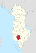
The district of Tepelena ( Albanian Rrethi i Tepelenës ) was one of the 36 administrative districts of Albania that were abolished in the summer of 2015 after an administrative reform. The area with an area of 817 square kilometers lies in the central mountainous region of southern Albania and belongs to the Qark Gjirokastra . The district was named after the capital Tepelena .
The Tepelena district had 19,606 inhabitants (2011). About three quarters of the population considers itself to be the Bektashi , the rest is half orthodox .

The area of the district includes a section of the valley of the Vjosa and some side valleys in the hills and mountains of southern Albania between Gjirokastra , Ballsh and Berat . Mighty mountains rise on the edges in the west and east, such as the Maja e Kendrevicës at 2122 m above sea level. A. west of Tepelena. To the east, the Vjosa passes through a mountain range in the Gryka e Këlcyrës gorge . Then it unites a little south of Tepelena with the Drino and on the northern outskirts with the Bënça . In the further course to the northwest to the Adriatic , the valley of the Vjosa widens more and more, as does the mountainous region to the northwest.
In the southwest lies the Kurvelesh , a secluded mountain region. The unspoilt landscape of Kurvelesh is characterized by karst rock, which formed numerous gorges and caves. There are approaches to ecotourism in the scenic area .
Apart from the Vjosa valley and the road from Fier in central Albania to Tepelena , most areas are very poorly developed. The Fier – Tepelena road ( SH 4 ) is the most important connection to southern Albania and also represents a connection to Greece . In 2012, a new route from Fier through the Vjosa valley to Tepelena was built to improve the development of the south.
Communities
The area of the district has been divided into the municipalities ( bashkia ) Tepelena and Memaliaj since 2015 , the other municipalities have been incorporated.
| Surname | Residents | Community type | Belongs to since 2015 |
|---|---|---|---|
| Memaliaj | 2,647 | Bashkia | Memaliaj |
| Tepelena | 4,342 | Bashkia | Tepelena |
| Buz | 737 | Komuna | Memaliaj |
| Fshat Memaliaj | 1,606 | Komuna | Memaliaj |
| Krahes | 2,554 | Komuna | Memaliaj |
| Kurvelesh | 705 | Komuna | Tepelena |
| Lopes | 723 | Komuna | Tepelena |
| Luftinja | 1,734 | Komuna | Memaliaj |
| Qendër Tepelena | 3,179 | Komuna | Tepelena |
| Qesarat | 1,379 | Komuna | Memaliaj |
Individual evidence
- ↑ a b Ines Nurja: Censusi i popullsisë dhe banesave / Population and Housing Census - Gjirokastër 2011 . Results Kryesore / Main Results. Ed .: INSTAT . Pjesa / Part 1. Adel Print, Tirana 2013 ( instat.gov.al [PDF; accessed April 14, 2019]).

Berat | Bulqiza | Delvina | Devoll | Dibra | Durrës | Elbasan | Fier | Gjirokastra | Gramsh | Has | Kavaja | Kolonja | Korça | Kruja | Kuçova | Kukës | Kurbin | Lezha | Librazhd | Lushnja | Malësia e Madhe | Mallakastra | Mat | Mirdita | Peqin | Përmet | Pogradec | Puka | Saranda | Shkodra | Skrapar | Tepelena | Tirana | Tropoja | Vlora