
Val de Réchy
| Val de Réchy | ||
|---|---|---|
 The Rèche river overcomes a cliff with a waterfall. |
||
| location | Valais , Switzerland | |
| Waters | Rèche | |
| Mountains | Crêt du Midi , Roc d'Orzival , Becs de Bosson , Mont Noble , La Maya | |
| Geographical location | 604 780 / 120664 | |
|
||

The Val de Réchy (also Vallon de Réchy ) is a small, uninhabited side valley of the Rhone in the south of the Swiss canton of Valais . It runs from south to north and is traversed by the Rèche brook, which finally flows into the Rhone. The northern, deepest part of the valley belongs to the municipality of Chalais (altitude 524 m above sea level ), the middle part to the municipality of Grône , while the highest part of the valley to the Becs de Bosson at an altitude of 3,149 m above sea level. M. belongs to the municipality of Mont-Noble (until 2011 Nax ).
Geographical location
The small valley between the Val d'Anniviers in the east and the Val d'Hérens in the west. It is framed to the east by the mountain range Crêt du Midi , Roc d'Orzival , Becs de Bosson and to the west by Mont Noble and La Maya . A mule track leads over the Col de Cou into the Val d'Hérens. At an altitude of 2567 m above sea level. M. is the small mountain lake Le Louché . From there the Rèche stream flows down into the valley, through the moorland of the Ar du Tsan and over a waterfall to the north. The listed Refuge de la Vallée de Rechy is located on the road that crosses the valley between Vercorin and Nax .
Flora and fauna
The valley has a typical alpine fauna with chamois, deer, marmots and ibex. In the moorland around the Ar du Tsan and in the alluvial areas of the Rèche there are species that are rare in Switzerland. There are also edelweiss and saxifrage .
Irrigation channels
The water of the Rèches has been passed through Suonen (Bisses) for centuries and used to irrigate the meadows. The 6.3 km long Bisse de Vercorin was built at the end of the 14th century on the right side of the valley. At an altitude of 1685 m, water is taken from the Rèche and directed onto the meadows of the Vercorin holiday village. SwitzerlandMobility's route no. 58 " Chemin des Bisses " leads along the old, still functioning water pipe. The second aqueduct in the valley, the Bisse de Réchy, is used to irrigate the Chalais fields and is still active today, albeit in tubes. It takes the water from the river at a height of 634 m and directs it to the fields above Chalais at a height of 566 m.
Establishment of the nature reserve
The valley, which itself is not suitable for alpine skiing , was discussed as a connection to the surrounding ski areas by means of ski lifts. Opponents of this development wrote a book about the "riches of the Vallon de Réchy", which was published in 1984 by WWF Valais. It demanded that it be placed under protection. The area around the Ar du Tsan was investigated between 1987 and 1991 by the Swiss Association for Plant Sociology. In 1988 an environmental impact assessment was carried out for the construction of the lifts. In 1989 an application was made to set up a nature reserve. The moor landscape above the Ar du Tsan in the area of what was then the municipality of Nax was added to the "List of moor landscapes of particular beauty and of national importance" in 1996. On April 1, 1998, the 3480 hectare “Val de Réchy - Sasseneire ” area was included in the “ Federal Inventory of Landscapes and Natural Monuments of National Importance ” (BLN - Object 1715).

View from the Val de Réchy to the mountain La Maya .
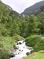
The Rèche river

The village of Réchy in the Rhone Valley.

Bisse de Vercorin


literature
- René-Pierre Bille, WWF Valais: Les richesses naturelles du vallon de Réchy: en vue de sa mise sous protection . WWF Valais, Martigny 1984.
- Vallon de Réchy - a scenic gem (PDF; 927 kB), Die Alpen 4/2002, pp. 44–51.
- Geneviève Tenthorey: Paysage geomorphologique du haut-val de Réchy (Valais, Suisse) et hydrologie liée aux glaciers rocheux . Freiburg im Üechtland 1993. Dissertation.
Web links
- vallonderechy.ch , private website for the Vallon de Réchy
Individual evidence
- ↑ a b 451.35 Ordinance on the protection of moorlands of particular beauty and of national importance , May 1, 1996.
- ↑ a b René-Pierre Bille, WWF Valais: Les richesses naturelles du vallon de Réchy: en vue de sa mise sous protection . WWF Valais, Martigny 1984.
- ↑ a b c Vallon de Réchy - a scenic gem (PDF; 927 kB), Die Alpen 4/2002, pp. 44–51.
- ↑ Pierre Carruzzo: Nax. In: Historical Lexicon of Switzerland .
- ↑ B – Objects VS 2018 . Canton du Valais Inventaire PBC, Objets B, État: 1.1.2018 (pas de changements pour 2018) / Kanton Wallis KGS inventory, B objects, status: 1.1.2018 (no changes compared to the previous year). In: babs.admin.ch / kulturgueterschutz.ch. Federal Office for Civil Protection FOCP - Department of Cultural Property Protection, January 1, 2018, accessed on December 31, 2017 (PDF; 357 kB, 11 pages, updated annually, no changes for 2018).
- ↑ Musée des Bisses: Bisse de Vercorin
- ↑ Hiking in Switzerland: hiking route 58 Chemin des Bisses
- ↑ Musée des Bisses: Bisse de Réchy
- ↑ Today the Vegetatio Helvetica working group of the Swiss Botanical Society
- ↑ a b c Réserve du Val de Réchy ( Memento of the original from October 1, 2013 in the Internet Archive ) Info: The archive link was inserted automatically and has not yet been checked. Please check the original and archive link according to the instructions and then remove this notice. , Website of the municipality of Grône , accessed on 25 September 2013.
- ↑ a b Vercorin - Grimentz - St. Martin - Nax connection ( Memento of the original of September 27, 2013 in the Internet Archive ) Info: The archive link was automatically inserted and not yet checked. Please check the original and archive link according to the instructions and then remove this notice. (PDF; 27 kB), cantonal structure plan - coordination sheet d.705 / 2, canton of Valais, May 5, 1999.
- ↑ Landscapes and natural monuments of national importance , admin.ch.