Gradient

The gradient (derived from the gradient ' uphill ' or ' downhill '), in Austria also Nivellette , describes the height profile of a planned or existing route in relation to the route ( axis ) in road and railway construction . It is made up of inclined straight lines (longitudinal slope) as well as dome and tub fillets and is shown in the profile plan .
Unit of measurement and calculation
Today, gradients are given in percent in road planning and in per mille in track planning. Further information that was used earlier is a mathematical fraction and an angle in degrees.
In the fractions, there is a height difference H in the numerator and the horizontal distance D to be covered in the denominator . If, for example, the height H increases by 10 m for every 100 m of horizontal distance D , the slope is 10: 100 = 1:10 = 0.1 = 10% = 100 ‰.
The arctangent function is used to obtain the slope as the angle α :
- ,
which results in ≈5.7 ° in the example.
The distance E to be covered on the inclined plane is according to the Pythagorean theorem
- ,
in the example ≈100.5 m.
In practice, the difference between the horizontal distance D read from a map, for example, and the distance E to be covered is mostly negligible. In contrast, the vehicle inclination of ≈5.7 ° occurring in the example is definitely noticeable and can not be neglected for reasons of driving dynamics .
Road alignment
The road must comply with certain parameters in order to comply with the dynamic driving parameters and visibility conditions. The heights given by the terrain must be overcome by sufficiently flat ramps. In addition, to ensure drainage, the relationship between the development of height and the development of curvature or the development of transverse slope must be observed in the site plan . This results in a spatial alignment .
Bend changes (S-curves) should z. B. do not come to lie in the tub , since then the drainage of the twisting section on transverse slope is difficult. The required rounding of the crests or troughs as well as the permissible gradients result from the road category according to RAL (guidelines for the construction of country roads).
The height difference to be overcome again by a subsequent downhill section is called the lost slope.
The traffic sign for the ascent or descent of a street uses the percentage notation. The total percentage of the maximum gradient of the route, rounded up, is given. This value is often adhered to along a longer route, as road builders try to keep the maximum gradient low by increasing the slope evenly.
At an angle to the road axis, locally higher gradients can occur in excessive curves. In order to reduce this disadvantage, the gradient along the road axis is significantly reduced (and the lane is also widened) in steep bends and especially in bends.
Due to the height of the center of gravity of a multi-axle vehicle and the vertical effect of gravity, the rear axle (s) is more heavily loaded when the vehicle is in an uphill position than in a horizontal position. With rear-wheel drive, the higher the contact pressure of the rear wheels on the ground, the greater the transferable propulsive power. With front-wheel drive, these two values decrease accordingly. Front-wheel drive is therefore almost only implemented by designers with the engine in the front. When combining a front engine with rear-wheel drive, the axles are placed as far forward as possible in order to put more stress on the rear drive axle. (See also trailing axle ). Motor vehicle drivers only have a certain influence on the load on the drive axle by moving the load or front seats forwards or backwards.
Cyclists on bicycles with a short wheelbase can move the main part of the total weight quite significantly by letting themselves "backwards" or "forwards" on the bike. By pushing in this way, in alternation with double the pedaling frequency, the propulsive power uphill can be evened out. When driving uphill in areas that are critical in terms of adhesion, you have to sit in a higher and further forward position. This shifting is limited by the risk that the front wheel "mounts", that is, the wheel tilts backwards. Conversely, when driving down a steep hill or when braking sharply, cyclists have to get low and slide backwards in order to counter the risk of tipping forward. Road racing bikes tend to be built short to reduce mass and increase stiffness. Mountain bikes for uneven terrain tend to be built a little longer.
Railway routing
In the case of railway lines within the German route network, the gradient generally refers to the upper edge of the rail that is not raised. Deviations from this occur within scissor ramps (so-called track scissors ), as special driving dynamics requirements result from a special geometric arrangement ( counter-arch ). In this case, the elevation of the outer rail must pass from one rail to the other.
Up until the beginning of the 20th century, gradients were given as a ratio ( fraction ) in railway construction in Germany , e.g. B. 1:80. 1: ∞ was specified for flat stretches. Today it is common to specify it in per mille , e.g. B. 12.5 ‰ (= 0.0125 = 1/80).
According to empirical values from Deutsche Bahn (as of 1994), new buildings with a maximum incline of 40 ‰ instead of 12.5 ‰ could save around 15% to 20% of the costs.
See also

- The road Ffordd Pen Llech in Harlech ( Wales ) has a portion with a maximum slope of 37.45%.
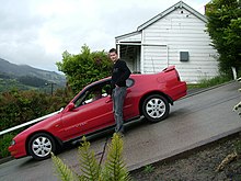
- The Baldwin Street is in the Guinness World Records made the steepest street in the world (about 35%).
- Directions to the Bontadini lift .
- In St Mawes , Cornwall can be found with 33% gradient one of the steepest streets in Europe.
Individual evidence
- ↑ German Bundestag: Answer of the federal government to a small question (...): Saving possibilities through new routing of railways for high-speed traffic taking into account the tilting train technology. (PDF; 327 kB). Printed matter 13/2130 of August 10, 1995.
Web links
- Road to the Col de Tanay in western Switzerland with a gradient of up to 35%
- Alpine route (33%) Via san Genesio Jenesien / San Genesio Alesino / Salten (Italy)
- Alpine route (up to 30%) to the highest approachable point in the Alps , Bontadini lift (Italy)


