Vindication Island
| Vindication Island | |
|---|---|
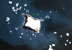
| NASA image of Vindication Island | |
| Waters | South Atlantic |
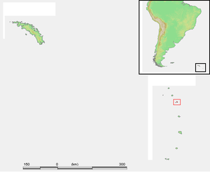
| Archipelago | South Sandwich Islands |
| Geographical location | 57 ° 7 ′ 2 ″ S , 26 ° 49 ′ 6 ″ W |
| length | 2.1 km |
| width | 1.6 km |
| surface | 3 km² |
| Highest elevation |
Quadrant Peak 430 m |
| Residents | uninhabited |
Vindication Island is a small, uninhabited island in the British overseas territory " South Georgia and the South Sandwich Islands " in the southern Atlantic Ocean .
Located in the archipelago of the South Sandwich Islands , the rectangular-shaped island forms the group of Candlemas Islands with the neighboring island of Candlemas Island , located just 4.5 km northeast across the Nelson Channel .
Vindication Island is the heavily eroded remnant of what was once a much larger volcanic complex , believed to have been formed from at least three eruption centers. While volcanic phenomena were observed several times on the neighboring island of Candlemas during the 20th century , Vindication has probably been inactive for thousands of years.
The two islands were discovered in 1775 by the British navigator James Cook .
literature
- Martin Wyatt Holdgate , Peter Edward Baker: The South Sandwich Islands: I. General description (= British Antarctic Survey Scientific Reports . No. 91 ). Natural Environment Research Council - British Antarctic Survey , Cambridge 1979, ISBN 0-85665-046-3 , IV. South Sandwich Islands - E. Vindication Island, p. 34–38 (English, online , PDF; 12.77 MB).
Web links
- Candlemas Island, South Sandwich Islands. With a brief description of Vindication Island. In: Volcano World . Oregon State University (English).
- Vindication Island ( Memento from November 28, 2010 in the Internet Archive ) in the island encyclopedia oceandots.com (English).
Individual evidence
- ^ Peter Edward Baker: The South Sandwich Islands: III. Petrology of the volcanic rocks (= British Antarctic Survey Scientific Reports . No. 93 ). Natural Environment Research Council - British Antarctic Survey , Cambridge 1978, ISBN 0-85665-045-5 , II.Summary of the geology of the South Sandwich Islands - 5. Vindication Island, p. 7 (English, online , PDF; 4.67 MB).

