Visokoi Island
| Visokoi Island | |
|---|---|
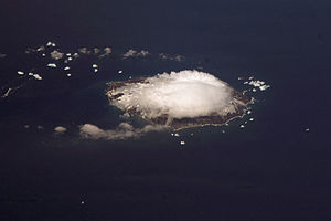
| NASA image of Visokoi Island | |
| Waters | South Atlantic |
| Archipelago | South Sandwich Islands |
| Geographical location | 56 ° 42 '40 " S , 27 ° 8' 50" W |
| length | 7.7 km |
| width | 5.4 km |
| surface | 34.5 km² |
| Highest elevation |
Mount Hodson 1005 m |
| Residents | uninhabited |
Visokoi Island is an uninhabited volcanic island of the British overseas territory " South Georgia and the South Sandwich Islands " located in the southern Atlantic Ocean .
The island is located about 600 km southeast of the main island of South Georgia and about 370 km north of the 60th parallel south in the archipelago of the South Sandwich Islands and, together with Zavodovski Island and Leskov Island, forms the small group of the Traversay Islands , the southernmost of which is Visokoi .
The 7.7 × 5.4 km large island with a land area of about 34.5 km² basically consists of a 1005 m high stratovolcano , Mount Hodson , which was last active in 1830 and 1930.
Visokoi Island was discovered and named in 1819 by the German-Baltic Antarctic explorer Fabian Gottlieb von Bellingshausen . He named the island after a Russian term for height , because of the impressive elevation of the volcanic mountain.
literature
- Martin Wyatt Holdgate , Peter Edward Baker: The South Sandwich Islands: I. General description (= British Antarctic Survey Scientific Reports . No. 91 ). Natural Environment Research Council - British Antarctic Survey , Cambridge 1979, ISBN 0-85665-046-3 , IV. South Sandwich Islands - C. Visokoi Island, p. 22–28 (English, online [PDF; 12.8 MB ]).
Web links
- Hodson in the Global Volcanism Program at the Smithsonian Institution .
- Hodson, Visokoy, Iceland, South Sandwich Islands. In: Volcano World . Oregon State University (English).
- Visokoi ( Memento from November 28, 2010 in the Internet Archive ) in the island encyclopedia oceandots.com (English).
Individual evidence
- ^ Matthew R. Patrick, John L. Smellie, Synthesis A spaceborne inventory of volcanic activity in Antarctica and southern oceans, 2000-10 . In: Antarctic Science . tape 25 , no. 4 , August 2013, ISSN 0954-1020 , South Sandwich Islands: Mount Hodson (Visokoi Island), p. 484 , doi : 10.1017 / S0954102013000436 (English).

