Vipava (river)
|
Vipava Vipacco, Wippach |
||
|
Map of the Isonzo river system: The Vipava flows into the Isonzo south of Gorizia |
||
| Data | ||
| location | Slovenia , Italy | |
| River system | Isonzo | |
| Drain over | Isonzo → Adriatic Sea | |
| source | in the village of Vipava southeast of Ajdovščina (Slovenia) 45 ° 50 ′ 41 ″ N , 13 ° 57 ′ 50 ″ E |
|
| Source height | 110 m. i. J. | |
| muzzle | near Savogna d'Isonzo as Vipacco in the Isonzo (Soča) Coordinates: 45 ° 53 ′ 56 " N , 13 ° 33 ′ 11" E 45 ° 53 ′ 56 " N , 13 ° 33 ′ 11" E |
|
| Mouth height | 35 m slm | |
| Height difference | 75 m | |
| Bottom slope | 1.5 ‰ | |
| length | 49 km | |
| Catchment area | 760 km² | |
| Drain |
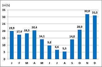
MQ |
17.5 m³ / s |
| Left tributaries | Močilnik , Branica | |
| Right tributaries | Hubelj , Lijak | |
| Small towns | Ajdovščina | |
|
The Vipava at the Tabor Bridge in Vipava |
||
The Vipava ( Slovenian ), Vipacco ( Italian ), also Wippach or Wipbach (historical German names), furlanisch Vipau , is a river in Slovenia and in the Italian region of Friuli-Venezia Giulia .
The length of the Vipava is 49 km, of which the last 5 km in Italy. The river has an abundant karst spring in the small town of Vipava . Shortly after Vipava, it takes up the much longer Močilnik coming from the Razdrto pass and first flows through the flat Vipavska dolina , at the western end of which it takes up the Hubelj , which is also fed by a strong karst spring and flows through the small town of Ajdovščina . The valley narrows at Ustje. The river runs in a west-northwest direction over Dornberk between the heights of the karst mountains of the Ternovan Forest and the hills of the Črni Hribi, which form part of the Vipavska brda . At Miren the Vipava forms a large bend in the river; then it crosses the border with Italy.
The battle of the Frigidus took place near the river valley in 394 (details in the Isonzo article ).
The Slovenian expressway Hitra cesta H4 runs roughly parallel to the river and continues to the west as the Italian autostrada A34 .
literature
- Goriška, Isletniška karta 1:50 000, Ljubljana: Geodetski zavod Slovenije, 2000.


