Vizianagaram
| Vizianagaram | ||
|---|---|---|
|
|
||
| State : |
|
|
| State : | Andhra Pradesh | |
| District : | Vizianagaram | |
| Location : | 18 ° 6 ′ N , 83 ° 24 ′ E | |
| Height : | 68 m | |
| Area : | 29.27 km² | |
| Residents : | 228,025 (2011) | |
| Population density : | 7790 inhabitants / km² | |
| Website : | http://cdma.ap.gov.in/VIZIANAGARAM | |
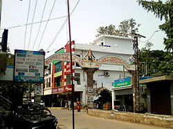
| Balaji textile market in Vizianagaram | ||
Vizianagaram is a city in the Indian state of Andhra Pradesh .
Vizianagaram is located at an altitude of 68 m, 20 km from the coast of the Bay of Bengal . The port city of Visakhapatnam is 45 km south . Vizianagaram is the administrative seat of the district of the same name . The national highway NH 43 (Rajapulova - Raipur ) runs through the city. The Chennai - Howrah railway also runs through Vizianagaram. At the 2011 census, Vizianagaram had 228,025 inhabitants. In December 2015, the city was elevated to the status of a Municipal Corporation .
Web links
Commons : Vizianagaram - collection of images, videos and audio files
Individual evidence
- ↑ www.census2011.co.in
- ↑ www.census2011.co.in
- ↑ Masula, Srikakulam, Vizianagaram upgraded into corporations . The Hindu. December 10, 2015.


