Machilipatnam
| Machilipatnam | ||
|---|---|---|
|
|
||
| State : |
|
|
| State : | Andhra Pradesh | |
| District : | Krishna | |
| Location : | 16 ° 11 ′ N , 81 ° 8 ′ E | |
| Height : | 10 m | |
| Area : | 26.67 km² | |
| Residents : | 169,892 (2011) | |
| Population density : | 6370 inhabitants / km² | |
| Website : | http://mmc.ind.in | |
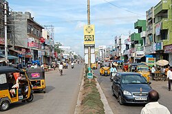
| Koneru Center | ||
Machilipatnam (also Masulipatnam or Masula ) is a city in the Indian state of Andhra Pradesh .
Machilipatnam is the capital of Krishna district . The city is located 355 km north of Chennai on the coast of the Bay of Bengal . The Krishna River flows into the sea 50 km south.
The national highways NH 9 (Machilipatnam - Vijayawada ) and NH 18 ( Kurnool - Chittoor ) meet in Machilipatnam.
At the 2011 census, the population of Machilipatnam was 169,892. In late 2015, the city was elevated to the status of a Municipal Corporation .
Personalities
Sons and daughters of the town:
- K. Chandrasekharan (1920-2017), mathematician
- A. Sharath Kamal (* 1982), professional table tennis player
Climate table
|
Monthly average temperatures and rainfall for Machilipatnam
Source: wetterkontor.de
|
|||||||||||||||||||||||||||||||||||||||||||||||||||||||||||||||||||||||||||||||||||||||||||||||||||||||||
Web links
Commons : Machilipatnam - collection of images, videos and audio files
Individual evidence
- ↑ www.census2011.co.in
- ↑ www.census2011.co.in
- ↑ Masula, Srikakulam, Vizianagaram upgraded into corporations . The Hindu. December 10, 2015.


