
Lochbach (Lech)
|
Lochbach Mühlbach |
||
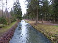
 The Lochbach in the Augsburg city forest |
||
| Data | ||
| Water code | DE : 126982 | |
| location | Bavaria , Germany | |
| River system | Lech | |
| Drain over | Lech → Danube → Black Sea | |
| Beginning |
Lech barrage 22 - Unterbergen 48 ° 14 ′ 15 ″ N , 10 ° 55 ′ 27 ″ E |
|
| muzzle | different canals in Augsburg Coordinates: 48 ° 17 ′ 52 " N , 10 ° 54 ′ 32" E 48 ° 17 ′ 52 " N , 10 ° 54 ′ 32" E
|
|
The Lochbach , formerly also called Brunnenlech , is a 9 km long left channel of the Lech in front of and in Augsburg . It is part of Augsburg's historical water management .
The name Brunnenlech probably goes back to the fact that the water power of the canal in the waterworks at the Red Gate was used to supply the fountains of Augsburg. Their drinking water was not drawn from the Lochbach, but from the Brunnenbach .
course

The Lochbach is diverted at the Lech barrage 22 near Unterbergen , at the so-called Lochbachanstich . First it runs close to the Lech and northwards parallel through the Lech floodplain forest . At the downstream end of the following Lech barrage 23 (Mandichosee), the Bayerbach , the Neue Graben branch off to the right, shortly afterwards the Alte Floßgraben , which all meander through the floodplain forest to the left of the Lech, while the Lochbach continues away from this and mostly runs on the western tree line or even in front of it. It is a total of six kilometers in length as the border between the populated area of Augsburg and the alluvial forest area.
The Mühlbach branches off in the Siebentischwald and runs back again at Haunstetten , from which the brook crosses an eastern tip; the further course is also called Mühlbach . Near the Haunstetter Strasse stop in downtown Augsburg, the Siebenbrunn stream coming from the city park on the right-hand side drains some of the ditches previously branched off into the floodplain forest back into the Lochbach.
The Lochbach passes the Augsburg University of Applied Sciences in the city center in front of the Red Gate . On Schülestrasse it splits into the Vorderen Lech and the Wolfsbach . The Vordere Lech, formerly also called Liupoldslech , used to be routed together with the Brunnenbach over the aqueduct at the Red Gate , crossing the city moat. The Lech water of the Lochbach was separated by a wooden partition from the water of the Brunnenbach flowing into it on the right, which is mainly spring water from the Lechau Forest, as this was used to supply Augsburg with drinking water until 1879. Today the Brunnenbach flows into the Lochbach before the university. This still flows as the Vorderer Lech over the historic aqueduct into the old town, through the Lechviertel , and flows into the Middle Lech at the Perlachberg.
The Wolfsbach, on the other hand, represents a cross connection to the Kaufbach , a canal that is fed by a second and for Augsburg even more important Lechanstich, the Hochablass . Its left branch, the Schwalllech , was formerly also routed via an aqueduct at the Schwibbogentor over the moat into the Lech district of the old town. This aqueduct has not been preserved. However, the water flow is still there today, it only runs under the road. At the St. Ursula Monastery, the Schwalllech is divided into two arms, the Middle and the Rear Lech.
The various Lech canals finally unite in the city stream and the city moat that runs parallel to it. In Augsburg-Oberhausen , after confluence with another right Lech Canal, the Proviantbach , they flow back into the Lech at the headland of the Wolfzahnau , less than two hundred meters before the acute-angled tributary of the Wertach from the left.
history
The Lochbach was already a canalised tributary of the Lech in the Middle Ages, which supplied the branching network of Augsburg canals with service water. As the Vorderer Lech, he drove four town mills as early as the 11th century, including the Pfladermühle .
In Haunstetten it has been used since the 19th century for the energy supply of the emerging industry (including Martini ).
In the Middle Ages the Lech flowed further to the west and shifted its river bed again and again, all in all to the east. In the 20th century, today's straightened and steady river bed, calmed with barrages and artificial surges, was created. By building canals on the Lochbach-Oberlauf and the aforementioned tapping of the Lech, it was ensured that the Lochbach continued to get water.
Flow
At Unterbergen, 4.74 m³ / s flow into the Lochbach, when it emerges from the Siebentischwald it only has a flow rate of about 2 m³ / s because the branched streams partly flow into another Lech Canal .

The Lochbach tapping

The Lochbach in the Lech floodplain forest
One of the many smaller and larger floods of the Lochbach
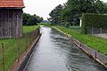
The Lochbach in Haunstetten

The Lochbach on the campus of the HS Augsburg


Individual evidence
- ↑ Günther Grünsteudel: Article about the Lochbach . In: Günther Grünsteudel, Günter Hägele and Rudolf Frankenberger (eds.): Stadtlexikon Augsburg . ( online [accessed March 6, 2010]). online ( Memento of the original from March 4, 2016 in the Internet Archive ) Info: The archive link was inserted automatically and has not yet been checked. Please check the original and archive link according to the instructions and then remove this notice.
literature
- Günther Grünsteudel: Article about the Lochbach . In: Günther Grünsteudel, Günter Hägele and Rudolf Frankenberger (eds.): Stadtlexikon Augsburg . ( online [accessed March 6, 2010]).