
Canals in Augsburg

The canals in Augsburg are a core component of Augsburg's historical water management . They have probably been supplying the city of Augsburg with water from the Lech and Wertach rivers , from the Singold and smaller streams since the 8th century . They are first reliably documented in writing in the Augsburg city law of 1276.
The city of Augsburg was built by the Romans at the northern end of the Augsburg high terrace between the untamed, intertwined mountain rivers Wertach and Lech. The place was easy to defend because the rivers naturally protected it from attacks from the west, north and east, and the high terrace, which is almost 20 meters above the river level, also adequately protected it from flooding. However, no natural watercourse ran through the city itself, so canals were created for this. The canal systems of Lech and Wertach run parallel to each other and flow back into the original river shortly before the two rivers merge in the Wolfzahnau .
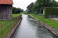
The water is distributed in the network-like Augsburg canal system in the gravity , i. H. freely following gravity, without being driven by any pumps. Most of the canals flow above ground with a strong volume flow and are only partially covered or overbuilt in the urban area. In the 1970s and 1980s, some canals in the old town were re-exposed.
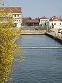
The water-filled moats that were built in the 16th century to fortify the city are also part of the canal network . There are several water crossings in the Augsburg canal network , such as the aqueduct at the Red Gate or the Zirbelnuss Canal Bridge at the Lower Fountain Tower . Above all, the Lech canals, which were routed through the lower old town center, which is also called the Lechviertel for this reason , make Augsburg a city of bridges . With a total of 500, it even surpasses Venice in terms of the number of its bridges - but this includes every footbridge that leads to a house entrance. 44 street names in the city area are directly related to the Augsburg waterfront.
On January 15, 2015, the historic Augsburg water management system was nominated for the UNESCO World Heritage List . The application was granted in July 2019, so that the canals have been part of the world cultural heritage since then.
meaning
The city brooks and canals served multiple purposes in the past centuries:
- they offered the rafting and timber drift a route of transport,
- their water power was used to drive water wheels for mills, for example, and later the turbines of factories or hydroelectric power stations ,
- they brought in service water for dyeing and tannery , for example ,
- they were used for waste and sewage disposal ,
- they secured the city wall by filling the moats ,
- they provided drinking water ,
- they supplied cooling water , for example for the Stadtmetzg (city butcher's shop) built in 1609 ,
- bathing took place in some canals; A canal on Friedberger Strasse still serves as an outdoor swimming pool today.
The drinking water from the springs in the Augsburg city forest was always kept strictly separate from the river water from the canals, which was only used as service water.
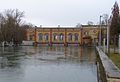
At the beginning of the 19th century there were 148 undershot water wheels in the city area. The streams that bring spring water, from which no drinking water has been taken since 1848, now flow into the Lech canals in the urban area. Most of the uses mentioned have since ceased to exist, but the Augsburg canal network remained intact and still shapes the cityscape. 36 hydropower plants in the Augsburg city area use the channels to generate electricity (as of 2013).
Total length according to origin
- Lech canals : total length 77.7 km
- Wertach Canal : total length 11.6 km
- Streams : total length 45.6 km
overview
Lochbach
Schäfflerbach

Senkelbach

Wolfsbach
All Lech canals lead to the Wolfzahnau hydropower plant at the end of the combined city and provisions stream


| Surname | origin | Receiving waters | location | length | Amount of water |
|---|---|---|---|---|---|
| Inlet channel | Lech (at the high drain ) | Capital stream (section parallel to Neubach), Neubach | Spickel-Herrenbach | approx. 45 m³ / s | |
| Capital stream (section parallel to Neubach) | Inlet channel | Eiskanal, Hauptstadtbach (section after the Neubach) | Spickel-Herrenbach | approx. 18 m³ / s | |
| Ice channel | Capital stream | Lech (after the high drain) | Spickel-Herrenbach | 660 m | approx. 10 m³ / s |
| Neubach | Inlet channel | Capital stream (section after the Neubach) | Spickel-Herrenbach | approx. 17 m³ / s | |
| Capital stream (section after the Neubach) | Capital stream | Kaufbach, Herrenbach | Spickel-Herrenbach | approx. 35 m³ / s | |
| Herrenbach | Capital stream (section after the Neubach) | Hanreibach, Proviantbach | Herrenbach | 882 m | approx. 21 m³ / s |
| Provision stream | Herrenbach | Unified city and provisions stream (outlet canal) | Spickel-Herrenbach | 4400 m | approx. 14 m³ / s |
| Hanreibach | Herrenbach | Fichtelbach, Proviantbach | Downtown | 2300 m | approx. 4 m³ / s |
| Fichtelbach | Hanreibach | Hanreibach | Downtown | 1400 m | approx. 4 m³ / s |
| Kaufbach | Capital stream (section after the Neubach) | Schwalllech, rafter | Downtown | approx. 14 m³ / s | |
| Schäfflerbach | Kaufbach | Stadtbach | Downtown | 3650 m | approx. 6 m³ / s |
| Schwalllech | Kaufbach | Middle Lech, Hinterer Lech | Downtown | 1400 m | |
| Rafter sheet | Kaufbach | Stadtbach | Downtown | 1400 m | approx. 3 m³ / s |
| Rear Lech | Schwalllech | Stadtbach | Downtown | 1400 m | approx. 2 m³ / s |
| Middle Lech | Schwalllech | Stadtbach | Downtown | 1400 m | approx. 4 m³ / s |
| Lochbach | Lech (Lech level 22 ) | Wolfsbach, Vorderer Lech, ... | Haunstetten, downtown | approx. 14.5 km | approx. 3 m³ / s |
| Wolfsbach | Lochbach | Kaufbach | Downtown | approx. 1 m³ / s | |
| Brunnenmeisterbach | Lochbach | Inner city moat (near the herb garden) | Downtown | ||
| Front Lech | Lochbach | Stadtbach (underground) | Downtown | 1260 m | approx. 2 m³ / s |
| Stadtbach | Vorderer, Mitteler and Hinterer Lech | Unified city and provisions stream (outlet canal) | Downtown | approx. 8 m³ / s | |
| Unified city and provisions stream (outlet canal) | Stadtbach, Proviantbach | Wertach (Wehr), Lech (after the hydropower plant on the Wolfzahnau ) | Wolf toothau | approx. 39 m³ / s | |
| Factory channel | Wertach | Wertach, Wertach Canal | Göggingen | approx. 28.5 m³ / s | |
| Singold | Source in Waal | Factory channel | Inningen, Göggingen | approx. 2 m³ / s | |
| Wertach Canal | Factory channel | Holzbach, Wertach | Göggingen | approx. 28.5 m³ / s | |
| Holzbach | Wertach Canal | Senkelbach | Downtown | approx. 28.5 m³ / s | |
| Senkelbach | Holzbach | Wertach | Oberhausen | approx. 28.5 m³ / s | |
| Mühlbach | Wertach Canal | underground alluvial channel to Wertach, Hettenbach | Pfersee | approx. 2 m³ / s | |
| Hettenbach | Mühlbach | Wertach | Pfersee | approx. 2 m³ / s | |
| Brunnenbach | Sources in the city forest | Lochbach | Downtown | ||
| Spitalbach | different channels in the Siebentischwald | Inner city moat | Downtown | ||
| Inner city moat | Spitalbach | Outer city moat, Malvasierbach | Downtown | ||
| Outer moat | Inner city moat | Malvasierbach | Downtown | ||
| Malvasierbach | Inner city moat, outer city moat | Stadtbach | Downtown | 680 m |
Lech canals
The Lech canals made a major contribution to Augsburg's industrialization early on. They flow through the lower old town in the Ulrichs and Lech districts, the Jakobervorstadt and also feed the inner and outer city moats along the eastern city wall. With the expansion of the city beyond the old fortifications, nine industrial canals were created between the old town and the Lech.
There are two lech stitches. The first is far south of Augsburg, today at the Lech barrage 22 - Unterbergen ; there Lechwasser flows into the Lochbach . A section of it between Haunstetten and Rotem Tor is called Brunnenlech . At the aqueduct at the Red Gate , the Lochbach and the Brunnenbach cross the moat. In the past, the Lech water from the Lochbach was meticulously separated from the water from the Brunnenbach flowing to the right with a wooden partition, because this served to supply Augsburg with drinking water. In the further course the Lochbach is called Vorderer Lech and later Stadtbach .
A second Lechanstich is located at the Hochablass , where the capital stream is derived from the Lech. This then separates into the Kaufbach and Herrenbach . The Herrenbach supplies the textile district and is divided into the Fichtelbach , Hanreibach and Proviantbach . The Proviantbach joins the Stadtbach in the Wolfzahnau and then flows back into the Lech.
The Kaufbach, on the other hand, supplies the streams east of the old town with water, such as the Mittlerer Lech or Hinteren Lech , and then joins the Vorderen Lech. The Schäfflerbach runs between the Kaufbach and the Stadtbach .
Today (as of 2013) the Lech canals are still used energetically with 23 small power plants.
The 20 km long Lech Canal , built at the end of the 19th century, accompanies the Lech on its left, initially at a distance of less than a hundred meters. It is diverted from the Lech at the height of Gersthofen , about 1.5 km after the confluence of the Wertach with the Lech in Augsburg, and only returns much further down the Lech at Ostendorf . At its beginning it is close to the Augsburg city limits, the border of which follows the left bank of the Lech, but everywhere outside. It is therefore not an Augsburg Canal.
Wertach canals
In contrast to the Lech, the Wertach only feeds very few canals in Augsburg, strictly speaking there are only two. Originally there were no Wertach canals at all. The Singold , flowing west of Augsburg , broke into the Wertach near Göggingen in 1588, causing its lower course to dry out. In the following year, the first tapping of the Wertach was made, which filled the underflow of the Singold again. This became today's Senkelbach Canal . The name is still reminiscent of earlier times when the Singold was also known as Sinkel, Senkel, Senkelt and Sinkalt.
In 1884 the factory canal was built in Göggingen as a right branch from the Wertach, and since then the Singold has also flowed into this canal. Further downstream, the factory canal becomes the Wertach Canal , and today it also feeds the Senkelbach via the short connection piece Holzbach .
To the left of the Wertach, in Pfersee, the Mühlbach branches off approximately at the height of the Rosenaustadion . Further down in Oberhausen it bears the name Hettenbach ; Hessenbach , which was also fed by him in the past , no longer exists today.
Originally outside the city limits of Augsburg, all of the above-mentioned Wertach canals are now located within the city of Augsburg. The Wertach canals are still used today (as of 2013) with 11 small power plants for energy generation.
Spring water streams
The spring water streams arise from numerous groundwater sources in the Augsburg city forest in the south of the city. They are traditionally referred to as "foundries". For centuries they brought drinking water to Augsburg. At the waterworks at the Red Gate, the water from the Brunnenbach has been pumped up into water towers since 1416 , which then fed the city's wells.
These streams flow today in the alluvial forest in a nature reserve and flow into the Lech or Lech canals.
literature
- Anton Werner: The hydropower of the city of Augsburg in the service of industry and commerce . Rieger Verlag, 1905.
- Martin Kluger: Historical water management and water art in Augsburg. Canal landscape, water towers, fountain art and water power . 2nd Edition. Context Verlag, Augsburg 2012, ISBN 978-3-939645-50-4 .
- Martin Kluger: Hydraulic engineering and hydropower, drinking water and fountain art in Augsburg . 1st edition. Context Verlag, Augsburg 2013, ISBN 978-3-939645-72-6 .
Web links
- City of Augsburg: How's Augsburg Water Going (PDF; 1.3 MB) Open Monument Day 2004
- Marcus Strehler, Harald Müller, Dusan Jakovljevic, David Sikazwe: Reactivation of decommissioned and defective hydropower plants in Augsburg, 2003 ( Memento from January 4, 2014 in the Internet Archive )
Individual evidence
- ↑ In the Augsburg city law book of 1276, four canals are recorded by name. See also Martin Kluger: Historical water management and water art in Augsburg: Canal landscape, water towers, fountain art and water power . Context Verlag, Augsburg 2012, ISBN 978-3-939645-50-4 , p. 33 . and Martin Kluger: Hydraulic engineering and hydropower, drinking water and fountain art in Augsburg . 1st edition. Context Verlag, Augsburg 2013, ISBN 978-3-939645-72-6 , p. 77 .
- ^ Hydraulic Engineering and Hydropower, Drinking Water and Decorative Fountains in Augsburg. In: whc.unesco.org. UNESCO World Heritage Center, accessed May 22, 2018 .
- ^ Lech canals as part of the Augsburg water management system. Retrieved September 4, 2019 .
- ^ Martin Kluger: Hydraulic engineering and hydropower, drinking water and fountain art in Augsburg. 1st edition. Context Verlag, Augsburg 2013, ISBN 978-3-939645-72-6 , p. 13 .
- ^ Martin Kluger: Hydraulic engineering and hydropower, drinking water and fountain art in Augsburg. 1st edition. Context Verlag, Augsburg 2013, ISBN 978-3-939645-72-6 , p. 12 .