
Augsburg city fortifications


The city of Augsburg has had a fortification since Roman times . In the Middle Ages new walls with towers and moats were built. The facilities have been expanded and strengthened over the centuries. Mid-19th century that began Entfestung the city of Augsburg and the demolition of many buildings in the attachment. Five city gates, four bastions and long sections of the city wall have been preserved up to the present day.
Overview
The city fortifications of the Roman city of Augusta Vindelicum probably consisted mostly of palisades . In the 8th century , Augsburg has been a bishopric since 738 and became a central place of the Franconian - Carolingian royal rule. As such, it needed adequate defenses.
Episcopal city

The first medieval wall was an almond-shaped palisade ring around the cathedral. The episcopal town protected in this way was located roughly between today's streets Hafnerberg and Mauerberg in the south and Jesuitengasse and Äußeres Pfaffengässchen in the north. Bishop Ulrich von Augsburg had the palisades of this cathedral castle replaced by a stone wall that was not yet very high. The wall had three gates, two of which were in the course of the Via Claudia Augusta : The south gate stood at the "Schwalbeneck" near the later fruit market on the site of the former Roman south gate. In the north stood the forerunner of the women's gate . A third gate was located on the western tip of the episcopal city near what would later become the prince-bishop's caste office (today an annex to the tax office). In a chronicle a "gate to the Lechen" is mentioned, but archaeologically no gate has been found on the east side of the episcopal city, and the old path from the south gate to the Lecharmen has been preserved to this day in the Schmiedberg street , which has a gentle slope Seitentals uses. From this first medieval wall, nothing can be seen from the outside today.
Upper city

South of the bishop's castle, the Via Claudia Augusta also served as a processional path from the bishop's church to the grave of Saint Afra . A market settlement formed along this section of the old trade route. In the 12th century , this area was provided with a stone wall and a deep moat just behind the church of St. Ulrich and Afra . The designation "Upper City" refers to the location upstream of the episcopal city. Not only does it stand on the elevated terrace , but its Lech district in the east lies at its foot and is traversed by three small Lech canals. The wall connected to the Domburg in the north with the swallow gate and also had four external gates: The Haunstetter gate, where the Red Gate stands today, was located along the Via Claudia Augusta. By Barfüßertor (once Sträfingertor named after the village Sträfingen, the forerunner of the Jakober suburb) in the east led the road across the Lech poor to Bayern . In the West began on Göggingertor the connection path in the village Augsburg Göggingen , from where you walk into the Allgäu arrived. The Heilig Kreuzer Tor in the northwest led to the Heilig Kreuz monastery, which was initially located outside the wall, and made it possible to pass the episcopal city into the lower Lech Valley.
Of the walls of the Upper City, in addition to the Red Gate, the upstream Rotetor bastion has been preserved and the wall that adjoins the gate complex to the north is mostly built into adjacent buildings until just before Margaretenstrasse. A section of the upper city wall extends from the bridge on the Schwall to the Vogeltor and connects to the Vogeltor on the other side of the (old) city moat. The outer city moat branches off from the city moat there.
Heilig-Geist-Spital with box tower, defensive tower converted into a water tower northeast of the Red Gate

Monastery garden of St. Ursula with the inside of the eastern wall of the Upper City south of the bird gate of Jakobervorstadt


Lower city

From the last years of the 13th century until 1308 another area was walled. In contrast to the Upper City, it is located entirely on the raised terrace. It connected to the north and thus downstream to the episcopal city with the Frauentor and in the far west to the Upper City with the Heilig Kreuzer Tor and was therefore given the name Lower City . The new wall received four external gates: From the clinker gate , the route led across the Wertach to Pfersee in the west. The trade routes to Ulm and Donauwörth led through the Wertachbrucker Tor . The Fischertor in the north led to the headland between Wertach and Lech. The Stephingertor (after the neighboring St. Stephan Abbey ) in the east was the shortest connection to the Lech.
The eastern wall on Schwedenweg (from opposite the lower connection of the outer city moat to the city moat), the Gallusbergle and Herwartstrasse to the Lueginsland, the Lueginsland tower , the northern wall from this to the Fischertor, the Wertachbrucker Tor , have been preserved from this walling . the wall at Katzenstadel from the Wachbruckertorstrasse to the south and the wall at the Blauenkap from the old Zeughausgässchen to the Klinkertorstrasse. Today's Fischertor is a building from 1924 adapted to modern road traffic.


Jakobervorstadt

In 1340 the urban area was extended to the east by the Jakobervorstadt . Like the Lechviertel of the Upper City, it is located on the lower terrace. Parallel to the inner city moat , which separates it from the older parts of the city , rafters flow through it. At first it received only a weak fortification of palisades and small trenches. A strong brick wall with towers and gates was not erected until a good hundred years later, in 1450. The outer city moat runs in front of it . The road to Bavaria passed the new wall through the Jakobertor, which still exists today . The Oblattertor in the north and the Vogeltor in the south were built near the connections to the old city wall . Of the other towers of this wall, the five-ridge tower has been preserved, probably the last remaining tower of the crowd guards who patrolled through Augsburg to ensure the night's sleep.
In addition to the bird gate with a short piece of the bird wall adjoining it to the east, the Jakobertor and the Fünfgratturm, the bastion at the northeast corner of the outer city moat has been preserved, and the adjoining northern wall 'Oblatterwall' up to Franziskanergasse. To the north of the Jakobertor, a piece of the city wall is built into houses built on the outside. Guard buildings still stand from the bastion on the southeast corner.

Inside of the Jakobermauer and Jakobertor from the north

Bird Gate , outside from the south


.jpg)
history
antiquity

Already in the early Roman Empire Emperor was the stepsons of Augustus , Drusus and Tiberius , a military camp in today Oberhausen built that to v 15th Chr. Was founded and even then had a small temporary attachment. Augusta Vindelicorum was not created until 30 years later on a threshold between the two rivers Wertach and Lech . After the completion of its fortification, which consisted almost entirely of wooden palisades, it was raised to a municipality by Emperor Hadrian . This municipality only reached as far to the south as the later episcopal city, but further north than the lower city of the Middle Ages, whose southern area was later covered by the episcopal city and the lower city. Nothing is left of the city fortifications from that time.
Medieval conditions
Augsburg was repeatedly involved in armed conflicts in the course of its history, and by the time of the Roman Empire Augsburg was repeatedly exposed to minor attacks, which is why the well-armed city fortifications had visibly paid off over the past centuries. It came to the limits of the Augsburg city fortifications when the defenders of the city in 955 had to face the approaching Hungarians at the time of the Hungarian invasions . Under the leadership of Bishop Ulrich , who was jointly responsible for the fortification of the city, the Augsburgers stood together with an army from Saxony , Swabia , Bavaria , Franconia and Bohemia and won the so-called battle on the Lechfeld . At this time the already poorly armed city defenses were particularly badly affected, but withstood the constant attacks of the Hungarians.

Even during the Thirty Years War Augsburg was exposed to several attacks, but was always able to defend itself, although the city was often chronically understaffed. An extreme situation occurred in the winter of 1634 and 1635 , in which a Catholic - Bavarian army tried to starve the city and besieged it all winter. The aim of the besiegers was to recapture the city from the Protestant Swedes who had occupied Augsburg for a long time. A large part of the population perished and starved to death. In the same war only twelve years later, in 1646 , the city was badly hit with heavy cannon fire. The " Stone Ma ", an Augsburg legend, as well as the Schwedenstiege , a staircase named after the occupiers, still reminds of this time. A few years later, in 1703 , Augsburg witnessed another siege, this time when a French-Bavarian army damaged the city fortifications during the War of the Spanish Succession by heavy bombardment and finally took the city in February 1704 . The French caused another wave of rearmament and retrofitting in Augsburg, with the Bavarians first ordering large parts of the fortifications to be razed before they had the destroyed bastions expanded. In particular, the Lueginsland at the northeast tip of the old town wall was expanded into a citadel.
So far it has been striking that in the event of a siege, the city was never taken by force of arms, but fell into the hands of the enemy through voluntary surrender. Up until the Wars of Liberation at the beginning of the 19th century , when Napoleon Bonaparte himself visited the city, there was always lively interest in the now well-armed city. But not only the fortification experienced a low point, but above all the city itself, when large numbers of human lives and buildings fell victim to the air raids in the Second World War .
Medieval building history


The fortification system of the imperial city was built on the medieval elements of the wall, tower and moat at the beginning of the 16th century . It is characterized by the high wall belt, reinforced with more than 100 slim, predominantly rectangular towers . At that time Augsburg was clearly separated from the suburb to the east by wall sections from the actual core city, and one could only fall back on the inner gates to get into the city. The separation wall to Jakobervorstadt remained in its security function for a relatively long time due to its elevated position. At that time Augsburg was equipped with a total of 11 external gates. All but the old entrance to the city theater were built as gate towers. The observation tower on Lueginsland , which gave the city a special accent, stood out in particular. Even before that, in the second half of the 15th century, in the course of the fortification expansion, the walls were provided with covered galleries for better local defense and low breast walls were drawn around the city moats. Furthermore, the section of the wall between the Red Gate and the Judenwall was reinforced by rectangular towers, whereas protruding bulwarks and gun places were missing. In addition, settlements that were located directly in front of the city walls were demolished at such points in order to gain a free apron for the city defenses.
The further development of weapon technology flowed into the city fortifications of Augsburg, especially with the improved gun technology. Since the invention of gunpowder , the city's parapets were no longer relevant. Since potential attackers had had cannons long before, Augsburg urgently had to upgrade. So it happened that the powerful iron balls also took into account the building of the wall. In 1519, Nuremberg engineers recommended the removal of the towers at wall level and the construction of bastions at the corners of the city. These suggestions were incorporated into the new development plan in 1538 . The modernization of the fortress belt took 15 years. So were z. B. in the years 1541 to 1545 in particular the corner points were reinforced with rounded, outstanding bastions. The trenches were also given a general overhaul. Despite the financial sacrifices that the imperial city had to make, the city was not yet optimally protected. Another important redesign of the city fortifications extended to the period between 1605 and 1625 , exactly the years in which Elias Holl , probably the best-known city architect, gave the complex a new face. Almost all gate towers were renewed at that time and brought into line with the Renaissance style , with Holl pursuing more representative goals and neglecting qualitative defense. So he supplemented the towers with high structures again, which resulted in a recourse to outdated forms of fortressing. Only the Jakobertor and Vogeltor were spared such changes.

When Augsburg was besieged and captured by the Swedes during the Thirty Years War , the Swedish King Gustav Adolf got an idea of the old city fortifications. Therefore, in 1632 , he had the entire facility modernized from scratch. He entrusted one of his countrymen, the Swedish general quartermaster Isaac de Traittorens, with this task. He was responsible for the planning of the large urban development project and wanted to have a complete fortress ring built around the city based on the Dutch model. This should enclose the entire current city fortifications in an oval shape. However, the realization of this plan came to a very different result. The city was originally to be provided with a rampart consisting of many bastions and ravelins , but this was not implemented in order to shorten time and save money. The extended fortification, which was built between 1632 and 1635 , was concentrated almost exclusively on the eastern side of the city. In the western area of the city wall, individual protruding ravelins were built as an alternative. Because of the catastrophic condition of the outer ring, which was caused by several heavy bombardments, it was removed again between 1645 and 1648 and replaced by new individual systems. The original project was finally ended with the complete demolition of the outer jumps.
After the Thirty Years' War there was hardly any need to expand or improve the city fortifications, and their maintenance was neglected. Only after the War of the Spanish Succession was the city fortifications reinforced again. When the siege came in 1704 , several sections of the wall in the northwest were badly damaged. When the city fell to the enemy, Elector Max Emanuel ordered the razing of the city wall, whereupon large parts of the same section of wall fell victim to the laying down. The French then had the bastion on Lueginsland expanded into a citadel and had some structures converted. Last rehabilitation of urban defenses were 1734 / 35 implemented by Anton du Chaffat. After the last construction work was carried out by the Stadtgarden-private Johann Höfler, the fortifications were left in their former condition. Since then, at no other time have changes been made to the fortification, which itself was now used for peaceful purposes.
In 1806 Augsburg became a Bavarian garrison town and the fortifications became state property. Despite the poor condition, the state did not carry out any maintenance work on the facilities. At the beginning of the 19th century gates inside the city such as the Barfüßertor or the Heilig Kreuzer Tor were demolished. In March 1860 the Gögginger Tor was laid down at the behest of King Max II . In 1866 , King Ludwig II issued the decree releasing Augsburg from the status of a fortress . The city bought back the facilities for 200,000 guilders and began to lay down. The first sections of the wall fell in 1867, and the candle arch gate was also demolished. At some gates, such as the Jakobertor , there was resistance among the population to the demolition, so that they were preserved. The Frauentor however, was not received despite opposition, as has been hampered by the cramped passage of at that same time greatly increasing traffic.
The city wall today


Most of the historic city wall was largely removed in the 19th century. Today there are remains of the old city fortifications at various points in Augsburg. The completely intact area of the city wall covers a total length of up to four kilometers, which runs from the extreme north to the southern tip of Augsburg's old town . Connections with the fortification can also be found in everyday life in Augsburg. For example, many street names are named after the old boundaries. Terms such as Oberer Graben, Unterer Graben, Schleifgraben, Vogelmauer, Jakoberwallstraße, Oblatterwallstraße, Schwedenweg or Stephingergraben can still be found today and name the early medieval walls and moats that were formed around the city. Above all, however, the city gates that still exist today should be remembered, such as B. the Jakobertor , which is now located in the middle of a huge roadway, as well as the Vogeltor . Interestingly, large parts of the city wall were simply incorporated into the newly built houses instead of being laid down. That is why there are some towers in the alleys and on the edges of the old town, which protrude above the city in the middle of apartment blocks or on public buildings (photo examples of the historical division of the wall in the overview section ). However, weather conditions and air pollution affect the structure of the walls and towers. Since the beginning of the 21st century, certain sections have been classified as prone to collapse at times. Signs such as “Falling stones, step on at your own risk” indicated the poor condition of this Augsburg cultural asset. The Vogeltor and the Jakobertor, which are located on roads with heavy traffic, show particularly severe damage from pollution. For some time now, some parts of the city wall have been repaired and thus preserved for the future. The Augsburg City Wall Association was founded in 2012 in order to maintain the city wall through lobbying and donations. Other institutions also contribute to the financing of the city wall with donations.
Lueginsland

The Lueginsland is next to the red gate wall system the best preserved bastion in the city. In the Middle Ages, it was most frequently exposed to sieges because of its strategic importance. Over the centuries it was severely demolished several times. After years of redesign, the bastion was not demolished, but remained and was even subjected to an extensive renovation campaign at the beginning of the 20th century , whereby a small recreational area was created from the once warlike bastion . The name of the bastion is derived from the southern German dialects: "Lueg ins Land" is equivalent to "Schau ins Land". The bulwark probably got this name because of its exposed location on the highest point of the Augsburg high terrace . This is one of the reasons why Emperor Sigismund of Luxembourg had an eight-story observation tower built in 1450 , which was oversized by the standards of the time and cost the city a total of 6,000 guilders . There is now a beer garden on the site of this tower. But like many other remains of the old city wall, the Lueginsland did not fare well until recently when several sections of the wall threatened to collapse. These were temporarily supported with several temporary wooden beams and the small paths and the street below the wall section were blocked. Recently, however, the repair of the system has been started again.
Sweden stairs

The 71-step Schwedenstiege is at the height of the Oblatterwall , where the core city and Jakobervorstadt meet. It crosses the lower ditch there and maintains several defensive towers, the Sweden Wall and the Steinerne Ma at the highest point . After the Swedes had taken the city by peaceful surrender in 1632 , they had a staircase built over the moat to create a better connection to Jakobervorstadt and its curtain walls. In 1954 , the stairs were supplemented with a vertical retaining wall about 80 centimeters high in order to underpin the stairs extensively. The bricks were used in the " Drei Mohren " hotel building that was destroyed in World War II . The Schwedenstiege is mostly known for the maintenance of the Steinernes Maas, a stone figure in honor of an urban hero who, according to legend, confused the enemy with a ruse during a siege. Today the Schwedenstiege is unfortunately sprayed with graffiti in many places.
Waferwall
The Oblatterwall is the part of the wall that lies down from the Schwedenstiege to the east. It is best known for the fact that it is located on the Augsburger Kahnfahrt and maintains the Fünfgratturm, although it is not directly connected to the wall. Around the Oblatterwall there is still the moat that extends to the Red Gate in the extreme south of the city wall. For more than a hundred years it has been possible to take the Augsburg boat ride on it, which leads from the Unteren Graben to the Oblatterwall. On the Oblatterwall there is also the Fünfgratturm, also known by the general population as the five-finger tower, which, however, does not directly border the wall, but is only in the street of the same name. In the 19th century, long sections of the wall were also removed here in order to redesign the narrow fortification ring to form the city park. Since 2007, a modern steel staircase has improved access to the tower.

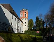
Red gate wall
The Red Gate Wall takes its name from the Red Gate , which is named after its characteristic red paint. The Rote Torwall is still the largest preserved fortification in the city and forms the extreme southern tip of Augsburg's old town . At this bastion the bridge over the moat has been preserved. It is two storeys. The lower level is the aqueduct at the Red Gate , through which industrial and drinking water was fed into the city. Since the invention of gunpowder , the bulwark around the Red Gate has been greatly expanded and a ditch has been added to protect against enemies. Today the complex is home to the city-famous open - air theater , a large herb garden and some of the old Augsburg water towers . In contrast to many other areas of the old town , in the area around the Rote Torwall the wall was only removed in the west, in the east it has been preserved in its former condition. The decay of the city wall has so far also affected some parts of the bastion, but essentially not as much as other areas.
The Augsburg herb garden , also the herb garden at the Roten Tor , which was laid out in the redesigned city moat of the Rote-Torwall-Anlagen and there on the area of the former vegetable garden of the adjoining Heilig-Geist-Spital , shows, among other things, aromatic and tea herbs. The “Augsburg Herb Garden” was created by the city of Augsburg in the early 1980s on the occasion of the Augsburg State Garden Show in 1985, based on the model of medieval monastery gardens and inaugurated in 1983. At the edge of the herb beds bordered with boxwood is a 3.25 meter high, white "history column ", which provides information on the more than 2000-year history of the city with numerous relief images .

Red gate with outer gate, bastion and bridge as seen from the open-air theater

Bridge (above) and aqueduct (below) in front of the Rotetorbastion

The herb garden below the Heilig-Geist-Spital , behind the box tower
.jpg)


topography
At the episcopal city, steep slopes on the eastern and partly on the southern edge contributed to the natural security.
In the case of the Upper City, the natural conditions were of little use: in the west and south the foreland was just as high as the city, and in the east part of the lower terrace was included so that the wall partially stood in front of the foot of the slope.
The use of natural steep slopes can be seen on the east side of the Lower City, for example on Schwedenweg and at the Gallus Chapel.
Imperial City Gates
| Surname | construction time | cancellation |
|---|---|---|
| Red Gate | circa 1187 | - |
| Hall gate | 1807 | 1878 |
| Gögginger Tor | circa 1180 | 1860 |
| Old inlet | 1514 | 1868 |
| Clinker gate | 1358 | 1874 |
| Wertachbruck Gate | 1370 | - |
| Fisherman's gate | 1328 | - |
| Stephingertor | 1304 | 1869 |
| Oblattertor | 1449 | 1867 |
| Jakobertor | 1249 | - |
| Bird gate | 1445 | - |
| Candle arch gate | 1306 | 1867 |
| Holy cruiser gate | approx. 11th century | 1807 |
| Frauentor | 1143 | 1885 |
| Barefoot gate | approx. 11th century | 1826 |
Gates
In addition to the large imperial city gates, there were also the following small side gates or gates, the importance of which was less:
- Bleichertörle (also Neibad or Walktörle) at the Sieben Kindeln
- Knäpplinsthörlein
- Südttor ( Schwalbeneckor )
Bastions
literature
- Franz Häussler: Augsburg's goals . Wißner-Verlag, Augsburg 2002, ISBN 3-89639-346-4 , p. 108 ff .
- Hermann Kießling: towers - gates - bastions . Brigitte Settele Verlag, Augsburg 1987, p. 12-26, 64 .
- Roswitha Mitulla: Walk through old Augsburg. Presse-Druck- und Verlags-GmbH Augsburg 1987
Web links
Individual evidence
- ↑ Andreas Mayer: The Augsburg herb garden . In: Natural Science Association for Swabia (Ed.): Reports of the Natural Science Association for Swabia . tape 116 , 2012, p. 2–14 ( digitized version [PDF; 6.0 MB ; accessed on August 16, 2018]).