Vosloorus
| Vosloorus | ||
|---|---|---|
|
|
||
| Coordinates | 26 ° 21 '30 " S , 28 ° 12' 27" E | |
| Basic data | ||
| Country | South Africa | |
| Gauteng | ||
| metropolis | Ekurhuleni | |
| ISO 3166-2 | ZA-GP | |
| height | 1563 m | |
| surface | 32.1 km² | |
| Residents | 163,216 (2011) | |
| density | 5,084.6 Ew. / km² | |
| founding | 1963 | |
|
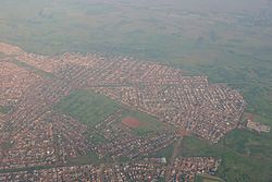
Aerial view of Vosloorus (towards southeast with Riedspruit)
|
||
Vosloorus ( Afrikaans ; German about "Vosloos rest") is an administrative part of the metropolitan municipality of Ekurhuleni in the South African province of Gauteng .
geography
In 2011 Vosloorus had 163,216 inhabitants. The district is located south of Boksburg . The township Katlehong is located immediately southwest, Thokoza west of Katlehong. Vosloorus is divided into numerous units, most of which are referred to as extensions numbered 1 to 8 , some of which have a second digit. In the southwest the Riedspruit river forms the border. In 2011, 47% of residents said isiZulu and 18% Sesotho as their first language.
history
Vosloorus was established during the apartheid period in 1963 as a township for black South Africans who had been expelled from Stirtonville, which is closer to Boksburg. Stirtonville subsequently became a settlement area for Coloreds . 1983 Vosloorus received parish status. In 2000 it became part of the Ekurhuleni Metropolitan Municipality. In 2014 the Natalspruit Hospital in Katlehong was closed and reopened in Vosloorus.
traffic
The National Route 3 leads directly to the northeast edge Vosloorus' along. Railways pass Vosloorus several kilometers away.
Individual evidence
- ↑ a b 2011 census , accessed October 29, 2014
- ↑ Harry Mashabela: townships of the PWV. SAIRR , Johannesburg 1988, ISBN 0869823434 , p. 169. Digitized
- ↑ Report at sanews.gov.za ( Memento from October 31, 2014 in the Internet Archive ) (English)

