Wölpe (aller)
| Wolf | ||
| Data | ||
| Water code | DE : 48968 | |
| location | Germany , Lower Saxony | |
| River system | Weser | |
| Drain over | Alpe → Aller → Weser → North Sea | |
| source | East of Nienburg / Weser 52 ° 39 ′ 26 ″ N , 9 ° 14 ′ 58 ″ E |
|
| Source height | 27 m above sea level NN | |
| muzzle | South of Rethem in the Alpe Coordinates: 52 ° 47 '40 " N , 9 ° 21' 45" E 52 ° 47 '40 " N , 9 ° 21' 45" E |
|
| Mouth height | 18 m above sea level NN | |
| Height difference | 9 m | |
| Bottom slope | 0.46 ‰ | |
| length | 19.6 km without the Alpe-Wölpe-Umfluter section (2.29 km) | |
| Catchment area | 56.4 km² | |
| Discharge at the gauge Anderten A Eo : 52.9 km² Location: 3.6 km above the mouth |
NNQ (Aug. 24, 1989) MNQ 1982–2012 MQ 1982–2012 Mq 1982–2012 MHQ 1982–2012 HHQ (Jan. 22, 2008) |
32 l / s 90 l / s 430 l / s 8.1 l / (s km²) 1.92 m³ / s 3.82 m³ / s |
| Discharge at the mouth of the A Eo : 56.4 km² |
MQ Mq |
450 l / s 8 l / (s km²) |
| Left tributaries | Schipsegraben (upper part) | |
| Right tributaries | Schwarze Riede, Weißer Graben | |
| Medium-sized cities | Nienburg / Weser | |
| Small towns | Rethem (Aller) | |
| Communities | Anderten (Heemsen) , sticks | |
The Wölpe is an almost 20 km long left tributary of the Alpe that flows to the Aller .
Course and characteristics
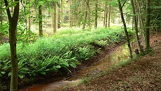
The Wölpe rises in a lowland area southeast of Erichshagen-Wölpe , a district of the city of Nienburg / Weser . It initially runs parallel to the Führser Mühlbach , which runs only around 300 meters further south- west and which is heading north-west towards the Weser . After two kilometers, the Wölpe turns to the northeast and after another 800 meters at the Erichshagen-Wölpe district of Nienburg, it passes the castle hill of the lost Wölpe Castle , once the seat of the Counts of Wölpe . After running 4 kilometers through quarry forest, the trench-like brook near Heemsen flows past the site of the Brunsburg castle, which was built in the 9th century .
The Wölpe runs here in wide arches through the valley sand plain of the Aller-Weser glacial valley , on both sides barely a kilometer away accompanied by the Schipsegraben and Schwarze Riede watercourses, which later flow into it , also running in wide oscillations. The Schipsegraben, which opens from the left at Anderten, used to run independently further to the northeast to the Aller. The Schwarze Riede drains the western lowland of the great Lichtenmoor .
Before Rethem , the Wölpe flows into the Alpe today , which is brought in from the east via the Weißen Graben and is thus diverted around the old town of Rethem for flood protection reasons. This Alpe-Wölpe floodwater flows into the Aller near Wohlendorf (town of Rethem).
The largely straightened Wölpe mostly flows through grassland and forest areas and, especially south of Rethem, arable land. According to the NLWKN's 2000 water quality map, the water is continuously critically polluted ( quality class II-III ).
Landscape history
The water system of the Wölpe runs mostly along old, partly Vistula- Cold Age stream channels of the Weser and, probably, also the today's Steinhuder Meerbach . In the course of the Wölpe, the turns of the channels roughly correspond to those of the Weser; the even more clearly recognizable gullies, which the Schipsegraben follows, have somewhat narrower winding radii. Before the centuries-old artificial breakthrough of the Führser Mühlbach to the Weser near Holtorf, the watercourse formerly known as Schips flowed over the path of today's Schipsegraben to the northeast to Aller near Rethem. There is still no evidence to support the assumption that the Meerbach also reached the Aller earlier this way.

The Wölpe was widened in the Middle Ages to form a graft to secure the fortifications and surrounded the castle and later palace complex that was built in the 12th century. After the facility was destroyed in the 17th century, the moat and the then Wölpelauf were filled with rubble.
In the course of straightening the Wölpe, the upper Schipsegraben was also brought to it. Initially, however, water was returned to the lower Schipsegraben at the same point. Since the Alpe was diverted to the smaller Wölpe in 1976, it has become a tributary of the Alpe. The former 2.3 kilometers long last Wölpe section is now part of the Alpe as the Alpe-Wölpe floodwater. The catchment area of the Wölpe was reduced by 3 square kilometers.
Web link
- ↑ a b Measurement in the topographic map 1: 25000
- ↑ Note: Mouth distance related to confluence with the Alpe ( Alpe-Wölpe-Umfluter )
- ↑ Gauge value Anderten increased by the drainage of the remaining catchment area (3.5 km²), which corresponds to that of the intermediate catchment area of the Rethem , Frankenfelderbruch , Anderten , Lehringen , Weitzmühlen , Dörverden and Intschede gauges (6.3 l / s km²)
- ↑ Water quality map of the NLWKN
