
Wörth (Danube Island)
| Wörth | ||
|---|---|---|
 |
||
| Waters | Danube | |
| Geographical location | 48 ° 13 '50 " N , 14 ° 53' 13" E | |
|
||
| length | 770 m | |
| width | 295 m | |
| surface | 13.5 ha | |
| Residents | uninhabited | |
_Joseph_Walcher_1791_map-2.jpg) |
||

The Wörth , also called Insel Wörth , is a river island in the Danube in Lower Austria .
geography
The island lies in a bend in the Danube at the level of the village of Hößgang, which, like Wörth, is part of the municipality of Neustadtl an der Donau ( cadastral municipality of Hößgang ). Werfenstein Castle (Upper Austria) is located on the left bank of the river in the village of Struden in the municipality of St. Nikola an der Donau .
The island with an area of 13.5 hectares is densely forested. There are three small ponds with a total area of 0.7 ha (0.4 ha in the north, 0.2 ha in the east, 0.1 ha in the south).
Before the construction of the Ybbs-Persenbeug Danube power plant , Wörth could be reached on foot from Hößgang via gravel banks when the Danube was low . Its current triangular shape can be traced back to numerous regulation work on the Danube from 1696 onwards and to dams built later. Both to the left and right of Wörth there is a fairway suitable for inland navigation.
At the height of the Donauinsel Wörth the Gießenbach flows from the left (north) into the Danube.
history
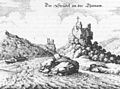
Wörth ( Merian 1649)
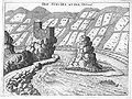
Wörth and Werfenstein Castle around 1674, engraving by GMVischer

Map of 1721 rocks in the Danube to the left of the Donauinsel Wörth

Old colored copper engraving from 1781 with rocks in the Danube to the left of the Danube island Wörth

Map from 1777 with rocky islands marked by name


_map_1777_map.jpg)

The island of Wörth is located in the middle of what was once the wildest stretch of the Strudengau with its then dangerous whirlpools and rapids, namely the whirlpool between the island and the town of Struden and the eddy , which is a little further down, at the level of St. Nikola. The vortex was dangerous because of the shallows and was easier to overcome when the water level was high, but the vortex was more difficult to circumnavigate during high water because it had more power and could grasp and break ships to a greater extent. The map section from 1777 shows that at that time between the Danube island of Wörth and the northern, left bank of the Danube, there were still at least 28 small and tiny rock islands (and five more in the Gießenbach estuary ), of which at least the eight largest had names: corn ball, wide ball, bomb crochet , Tricorn, wolf ball, forest crochet (the largest), wild crack crochet and the horse. The three largest, wild crack crochets, bomb crochets and forest crochets, were dreaded cliffs on which many rafts shattered. After extensive preparatory work, the first rocks were blown up in December 1777. These initial regulatory work lasted until 1791, continued in the mid-19th century, and finally completed in 1870-1914. With this, all barriers to shipping were removed.
For a long time, the Danube was an important long-distance route for ships, riders and pedestrians and could be easily controlled at the narrow point around Wörth. If one believes the appendix to the novel Die Trutzburg by Franz Herndl, then Romans had built a fort on the island in the time of Mark Aurel , from the ruins of which a castle emerged in the Middle Ages , the Burg Wörth . The latter is one of the line of castles around the Danube with the main castle Werfenstein , which is opposite. This line of castles also included Hausstein , Langenstein , Pain (Pahin, Bojenstein) and Helchenburg . The remains of the Wörthburg can still be found on the Wörthfelsen.
Around 1295 the island was sovereign and was pledged in 1314 to the petty aristocracy Albero von Volkersdorf , whose descendants named themselves after the seat from 1322. With the sale to the Prüschenk and the associated founding of the Prüschenk Castle in Greinburg , Wörth Castle may have lost its task. In 1552 the so-called Wörthkreuz was erected on the tower of the castle ruins, which is still preserved today.
The island of Wörth has been a nature reserve owned by the Republic of Austria since 1970 .
Web links
- Aerial view of the island on a historical postcard
- Entry about Wörth in Lower Austria Burgen online - Institute for Reality Studies of the Middle Ages and the Early Modern Era, University of Salzburg
Individual evidence
- ↑ pastor Tuma of Neustadel in representation of Erzherzogthums Austria under the Ens, from Baron Friedrich von Schweickhardt, Volume 8, 1837 , Section Hößgang, p 288
- ^ Joseph Walcher : News of the work carried out in 1778, 1779, 1780 and 1781 in the vortex of the Danube for the safety of shipping by the kais. Navigation Directorate on the Danube. Vienna 1781 ( digitized version ).
- ^ Joseph Walcher: News of the work that was continued until 1791 on the Danube vortex for the safety of shipping, along with an appendix on the physical nature of the Danube vortex. Vienna 1791 ( digitized version ).
- ↑ Alexander Szana: The new economic problems of the Danube, Stuttgart 1921 , p. 23 (Finanz und Volkswirtschaftliche Zeitfragen, 72nd issue)
- ↑ The stronghold of Franz Herndl, 1908 or 1909 with M. Altmann, Leipzig.
- ↑ entry to Wörth castle Wörthersee Castle in the private database "All Castles". Retrieved June 26, 2016.