
Wąsosz
| Wąsosz | |||
|---|---|---|---|

|
|
||
| Basic data | |||
| State : | Poland | ||
| Voivodeship : | Lower Silesia | ||
| Powiat : | Góra | ||
| Area : | 3.24 km² | ||
| Geographic location : | 51 ° 33 ' N , 16 ° 42' E | ||
| Residents : | 2662 (Jun. 30, 2019) |
||
| Postal code : | 56-210 | ||
| License plate : | DGR | ||
| Gmina | |||
| Gminatype: | Urban and rural municipality | ||
| Surface: | 193.59 km² | ||
| Residents: | 7161 (June 30, 2019) |
||
| Population density : | 37 inhabitants / km² | ||
| Community number ( GUS ): | 0204043 | ||
| administration | |||
| Mayor : | Zbigniew Stanisław Stuczyk | ||
| Address: | pl. Wolności 17 56-210 Wąsosz |
||

Wąsosz ( German Herrnstadt ) is a town in the powiat Górowski ( Guhrau district ) of the Polish Lower Silesian Voivodeship .
Geographical location
The city is located in Lower Silesia , about twenty kilometers southeast of the city of Góra ( Guhrau ). The Barycz ( Bartsch ) and the Orla flow through the village .
history
Herrnstadt was founded in 1290 by Duke Heinrich III. von Glogau according to the same German law as the cities Sagan and Sprottau ( Saganus et Sprotavia ) owned.

In the immediate vicinity of the central square of the city there are two churches and a castle.
In 1945 the city belonged to the Lower Silesia Province of the German Empire. It was the administrative seat of the district of Guhrau .
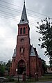
church

Interior of the church

Herrnstadt Castle


Towards the end of the Second World War , Guhrau was occupied by the Red Army in the spring of 1945 and a short time later it was placed under Polish administration. The city has now been renamed Wąsosz . Subsequently, the population was evicted by the local Polish administration and replaced by Poles.
Population development
| year | Residents | Remarks |
|---|---|---|
| 1885 | 176 | |
| 1890 | 1,982 | 1,552 Protestants, 379 Catholics and 47 Jews |
| 1925 | 2,229 | |
| 1933 | 2,532 | |
| 1939 | 2,968 |
local community
The urban and rural community ( gmina miejsko-wiejska ) has, in addition to the city of Wąsosz, the following districts ( German names until 1945 ) with a Schulzenamt ( sołectwo ) :
|
|
Other localities in the municipality are:
- Borovna ( Heidchen )
- Czaple ( Tschipkei , 1934–1945 Grohsau )
- Jawor ( dancing )
- Kobylniki ( Hengwitz )
- Marysin ( Marienruh )
- Młynary ( Nieder and Ober Struppemühle )
- Podmieście ( Stadtvorwerk ),
- Sądowel ( Tschistey , 1936–1945 Sandewalde )
- Stefanów ( Friedrichshof )
- Sułów Wielki ( Great Saul )
- Leśniczówka
- Unisławice ( Wilhelmsbruch )
- Zubrza ( Schubersee ).
Personalities
- Gottfried Held von Hagelsheim (1670–1724), physician
literature
- Karl August Müller: Patriotic images, in a history and description of the old castle festivals and knight castles of Prussia. Glogau 1837, pp. 253-254.
- Johann Georg Knie : Alphabetical-statistical-topographical overview of all villages, towns, cities and other places in the royal family. Prussia. Province of Silesia . Breslau 1830, p. 939.
Web links
Individual evidence
- ↑ a b population. Size and Structure by Territorial Division. As of June 30, 2019. Główny Urząd Statystyczny (GUS) (PDF files; 0.99 MiB), accessed December 24, 2019 .
- ↑ Gustav A. Tzschoppe u. Gustav A. Stenzel, collection of documents on the history of the origins of cities and the introduction and spread of German colonists and rights in Silesia and Upper Lusatia (Hamburg 1832), p. 408.
- ↑ a b c d e Michael Rademacher: German administrative history from the unification of the empire in 1871 to the reunification in 1990. guhrau.html # ew39guhrherrn. (Online material for the dissertation, Osnabrück 2006).
- ↑ The Genealogical Place Directory
- ↑ [1]
- ↑ [2]
- ↑ [3]
- ↑ [4]
- ↑ [5]
- ↑ [6]