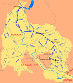
Awake (river)
|
Wake up Вах |
||
|
Course of the awake (Вах) in the catchment area of the Ob |
||
| Data | ||
| Water code | RU : 13011000112115200036930 | |
| location | Khanty and Mansi Autonomous Okrug / Ugra ( Russia ) | |
| River system | If | |
| Drain over | Whether → Arctic Ocean | |
| source |
West Siberian Lowlands 61 ° 18 ′ 13 ″ N , 85 ° 41 ′ 25 ″ E |
|
| Source height | approx. 150 m | |
| muzzle | in the Ob , 15 km east of Nizhnevartovsk Coordinates: 60 ° 48 ′ 56 " N , 76 ° 48 ′ 7" E 60 ° 48 ′ 56 " N , 76 ° 48 ′ 7" E |
|
| Mouth height | 32 m | |
| Height difference | approx. 118 m | |
| Bottom slope | approx. 0.12 ‰ | |
| length | 964 km | |
| Catchment area | 76,700 km² | |
| Discharge at the Lobchinskoje A Eo gauge : 56,400 km² Location: 253 km above the mouth |
MQ 1953/1996 Mq 1953/1996 |
536 m³ / s 9.5 l / (s km²) |
| Left tributaries | Bolshoi Megtygjogan | |
| Right tributaries | Kulynigol, Sabun , Kolikjogan | |
| Small towns | Isluchinsk | |
| Navigable | 432 km | |
The 964 km long Wach ( Russian Вах ) is a right tributary of the Ob in Siberia ( Russia , Asia ).
course
The Wach rises in the area of the watershed of Ob, Yenisei and Tas in the east of the West Siberian lowlands and flows along its entire length in a strongly meandering manner through the sparsely populated taiga areas in the east of the Autonomous Okrug of Khanty and Mansi / Ugra . The Wach flows into the Ob about 15 km above Nizhnevartovsk , which is 300 m wide and 5 m deep. The flow velocity near the mouth is 0.5 m / s.
Hydrography
The catchment area covers 76,700 km². It forms the settlement area of the eastern Khanty group . The mean monthly water flow at Lobchinskoje (in the middle course, 253 km above the mouth) is 540 m³ / s (minimum in March: 187 m³ / s, maximum in June: 1,679 m³ / s).
Infrastructure and economy
The Wach is navigable up to the mouth of the Sabun ( Сабун ) tributary (432 km; in addition, 6 km from the mouth of the Sabun up to the village of Larjak). The most important tributaries of the Wach are Kulynigol ( Кулынигол ), Sabun and Kolikjogan ( Коликъёган ; 253 km to the Podbasa pier) from the right and the Great Megtygjogan ( Большой Мегтыгъёган ) from the left.
In the area of the Wach lower reaches, important oil deposits such as the Samotlor oil field are exploited. Herein lies on the right bank near the mouth of the urban-type settlement Islutschinsk , a suburb of Nizhnevartovsk and only one with 16,400 inhabitants larger settlement on the river. A road bridge south of Isluchinsk on the connection from Nizhnevartovsk to Streschewoi in the neighboring Tomsk Oblast was completed in 2014 ( 60 ° 56 ′ 7.6 ″ N , 76 ° 53 ′ 24.2 ″ E ).
swell
- List of Inland Waterways of the Russian Federation (Government Decree of December 19, 2002, Russian)
Individual evidence
- ↑ a b Article Awake in the Great Soviet Encyclopedia (BSE) , 3rd edition 1969–1978 (Russian)
- ↑ a b Wach in the State Water Register of the Russian Federation (Russian)
- ↑ a b Wach at the Lobchinskoje gauge - hydrographic data from R-ArcticNET
- ↑ Trans Most: The bridge across the River Vakh on the road from Nizhnevartovsk to Strezhevoy

