Wall (Fehrbellin)
Wall is a district of the municipality of Fehrbellin in the Ostprignitz-Ruppin district in the state of Brandenburg . The street village has a size of 6 km², 168 inhabitants lived here in October 2009.
geography
Wall is located 24 kilometers (about 14 kilometers as the crow flies) east of Fehrbellin. The district is located on the northern edge of the Rhinluches .
history
People lived in the area around Wall from an early age. Objects from the Neolithic, Bronze Age and Iron Age were found around Wall, mostly on the border of a plateau with the Luch. To the east of Wall, shards and slag were found that indicate a settlement from the Roman Empire. There were also Slavic settlements around Wall .
In the year 1624 1655 also was located on the site of a sheep Wall, Vorwerk . In 1800 27 people lived here, in 1860 there were around 100 people. Until 1900 a road toll was taken from the estate for the dam from Beetz to Altfriesack , because the estate was responsible for maintaining the dam. From 1928 to 1932 32 settler sites were established, in 1933 Wall became an independent municipality.
A type III LPG was founded in 1954. There was also an LPG type I. Since 1992 Wall has belonged to the Fehrbellin office , since 2003 it has been a district of Fehrbellin.
Estate
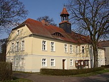
In 1701 there was a dairy farm here. Karl Friedrich von dem Knesebeck leased the state domain in 1825 and took over the estate in 1834/1835. The manor house was built in 1828, an inscription on a gable indicates: "FK vd K. 1828". In 1904 the house was expanded. After the community took over the house in 1934, it was converted into a school and a chapel was added. The house is a two-story building with a half-hip roof. There are bat dormers in the roof . On the park side there is a semicircular extension in the middle of the building.
Farm buildings from the mid-19th century still belong to the estate. This includes a horse stable and an ice cellar. The inspector's house is located next to the estate. The estate park has a size of about 2 hectares.
Others
There is an 18-hole golf course in Wall.
literature
- Monument topography Federal Republic of Germany, monuments in Brandenburg, district Ostprignitz-Ruppin, part 2: Fehrbellin community, Lindow (Mark) and city of Rheinsberg, Ulrike Schwarz and Matthias Metzler and others, Wernersche Verlagsgesellschaft, Worms am Rhein, 2003, ISBN 3-88462- 191-2 , pages 330-340
Individual evidence
Coordinates: 52 ° 49 ′ 18 ″ N , 12 ° 57 ′ 43 ″ E
