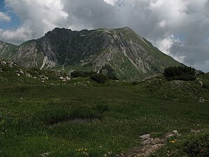
Goat horn
| Goat horn | ||
|---|---|---|
|
Geißhorn from Gemstelkoblach (south) |
||
| height | 2366 m | |
| location | Border Bavaria , Germany / Vorarlberg , Austria | |
| Mountains | Southeastern Walsertal Mountains , Allgäu Alps | |
| Dominance | 1 km → Liechelkopf | |
| Notch height | 186 m ↓ notch to the Liechelkopf | |
| Coordinates | 47 ° 17 '16 " N , 10 ° 10' 31" E | |
|
|
||
The Geißhorn (also Walser Geißhorn ) is 2366 m above sea level. NN high mountain in the Allgäu Alps on the German - Austrian border.
Geographical location
The border between Bavaria (Germany) in the east and Vorarlberg (Austria) in the west runs over the Geißhorn . It is located south-east of the Kleiner Walsertal about 15.5 km southwest of Oberstdorf , just under 3.5 km north of Warth and about 4 km northeast of the Hochtannberg Pass . To the east the landscape drops into the valley of the small Haldenwanger Bach , which flows into the Stillach over the Rappenalpenbach , and to the northwest it drops into that of the small Gemstelbach , which flows into the Breitach .
North of the Geißhorn is the Liechelkopf ( 2384 m ) and south of the Haldenwanger Kopf ( 2002 m ) with the Haldenwanger Eck ( 1930.6 m ) on the other side ; they are all border mountains too. To the west of Austria rises the Große Widderstein ( 2533 m ) with its northern foothills, the Kleiner Widderstein ( 2236 m ).
The gap height of the Geißhorn is at least 186 meters, its dominance 1000 meters, whereby the Liechelkopf is the reference mountain in each case .
Ascent
The summit can be climbed on the marked path from the east from the Mindelheimer Hütte via the south ridge. The saddle under the south ridge can also be reached from the north, from Bödmen through the Gemstelbachtal .
literature
- Dieter Seibert: Allgäuer Alpen Alpin, alpine club guide . Bergverlag Rudolf Rother , Munich 2004. ISBN 3-7633-1126-2
Web links
Individual evidence
- ↑ Map services of the Federal Agency for Nature Conservation ( information )
- ↑ Exact value not known, stated value is a minimum value (can be up to 19 meters higher). It was determined from the distance between the contour lines (20 meters in altitude ) on a topographic map ( scale 1: 25,000).

