
Great Aries Stone
| Great Aries Stone | ||
|---|---|---|
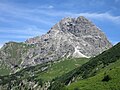
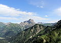
 Large Widderstein - North View from Ifen from |
||
| height | 2533 m above sea level A. | |
| location | Vorarlberg , Austria | |
| Mountains | Southeastern Walsertal Mountains , Allgäu Alps | |
| Dominance | 6 km → Mohnenfluh | |
| Notch height | 845 m ↓ Schrofenpass | |
| Coordinates | 47 ° 17 '6 " N , 10 ° 7' 45" E | |
|
||
| rock | Main dolomite | |
| First ascent | July 25, 1669 by pastor Peter Bickel from Schröcken | |
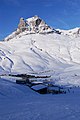
 The Große Widderstein from the Kleinwalsertal in winter |
||

The Great Widderstein (also Widderstein ) is 2533 m above sea level. A. high mountain in Vorarlberg in western Austria . Topographically it belongs to the Allgäu Alps . It is the highest mountain in the subgroup of the southeastern Walsertal Mountains .
Location and surroundings
The Widderstein is a mountain range in the frame of the Kleinwalsertal , which runs past it to the north. First, the Große Widderstein goes northeast, separated by the Karlstor (2100 m), to the Kleiner Widderstein (2236 m). In the east, the Gemsteltal separates the flanks of the Widderstein from the massif around the Elferkopf (2387 m) and the Walser Geißhorn (2366 m). In the south lies the Hochtannbergpass (1676 m), where the Allgäu Alps merge with the Lechquellen Mountains. To the west lies the Bärgunt valley and the massif around the Heiterberg (2188 m). The Hochalpsee (1970 m) lies in a hollow to the northwest under the summit flanks .
The border between the communities of Warth and Mittelberg runs across the mountain .
geology
The summit body of the Großer Widderstein consists of the main dolomite of the Lechtal cover , which is pushed onto the main dolomite of the Allgäu cover here . In the north-west in the area of the Hochalpsee there are Kössen layers .
Origin of name
The Great Widderstein was mentioned for the first time in 1059 in a document from the Augsburg bishopric : in Widerostein . Another mention was made in 1471 and 1485 with Widerstain . Blasius Huebers Vorarlbergkarte recorded a Widerstein Sp in 1783. The mention has the meaning "Stone of the Aries", which could stand for Capricorn as well as for the male sheep , the Aries.
Alpinism
First ascent
The first documented ascent of the Großer Widderstein took place on July 25, 1669, according to other sources in 1664 by a pastor Bickel from Schröcken.
Normal way
The normal route to the summit begins at the Hochtannbergpass and leads over meadow slopes towards the Widdersteinhütte . At about 2000 m a path branches off to the west, which leads to the rock of the Widderstein in just 15 minutes. From here a marked rock path ( UIAA I ) leads through a gully at risk of falling rocks to the summit ridge and from there crossing east to the summit cross.
This ascent / descent to / from the Widderstein summit is often the undoing of inexperienced or careless hikers. Every year there are several seriously injured or fatalities from crashes.
The start of the climb can also be reached from Baad in the Kleinwalsertal via the Hochalppass or from Bödmen through the Gemstelbachtal, at the Upper Gemstelalpe (1694 m) over the Gemstelpass to the Widdersteinhütte.
Climb
There are some climbing routes in the walls of the Widderstein. In the north face there is a route (difficulty IV + ) by E. König and R. Schmierle from 1897. The north pillar has the difficulty III / IV (one pitch in the lower area), the east ridge IV. The south-west face to the south-west summit III- IV was first climbed in 1951 by B. Segger and F. Hieber. Helmreich and Hutter climbed through the west face of the south shoulder (XI +) for the first time in 1935. The south ridge II-III, a point IV, was first descended by W. Blenk.
photos
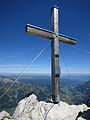
The summit cross
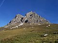
West view

East view
Summit, seen from the Saloberkopf
From the south by the rise of Hochtannbergpass seen from
Seen from Baad


panorama

Web links
Individual evidence
- ^ Herbert Scholz: Building and Becoming the Allgäu Landscape. E. Schweizerbart'sche Verlagsbuchhandlung (Nägele and Obermiller), Stuttgart 1995, pp. 31, 35, T15.
- ^ Thaddäus Steiner : Allgäu mountain names. 2nd Edition. Kunstverlag Josef Fink, Lindenberg 2008, ISBN 978-3-8987-0389-5 , p. 217 f.
- ↑ a b Dieter Seibert: Alpine Club Guide alpine - Allgäu Alps and Ammergau Alps. 17th edition. Bergverlag Rother, Munich 2008, ISBN 978-3-7633-1126-2 , p. 194.
- ↑ dpa / sey: Two German hikers die after falling into a snow hole. In: welt.de , June 5, 2019, accessed on August 28, 2019; - Holger Mock: lost balance. Fatal alpine accident in Mittelberg: woman (44) crashes on the Widderstein. In: all-in.de, accessed on August 28, 2019.
- ↑ Ernst Zettler, Heinz Groth: Alpine Club Guide - Allgäu Alps. 12th, completely revised edition. Bergverlag Rudolf Rother, Munich 1985, ISBN 3-7633-1111-4 , pp. 473-478.