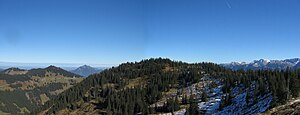
Tub head (group of horns)
| Tub head | ||
|---|---|---|
|
Tub head: Wooded ridge in the center of the picture |
||
| height | 1712.2 m above sea level NHN | |
| location | Bavaria , Germany | |
| Mountains | Pre-Alps west of the Iller , Allgäu Alps | |
| Dominance | 2.2 km → Riedberger Horn | |
| Notch height | 112 m ↓ notch to the Riedberger Horn | |
| Coordinates | 47 ° 26 '52 " N , 10 ° 11' 32" E | |
|
|
||
| rock | Flysch | |
| First ascent | by locals | |
The tub head is 1712 m above sea level. NHN high mountain of the Hörnergruppe in the western Allgäu Alps , located in the Bavarian district of Oberallgäu .
Location and surroundings

The tub head rises about 3.5 km west of Obermaiselstein . A pass road leads south past the mountain over the Riedbergpass ( 1420 m above sea level ), located around 1.8 km southwest , which connects Hittisau ( Vorarlberg , Austria ) in the west and Fischen im Allgäu ( Bavaria , Germany) in the east. The larger western neighbor mountain is the Riedberger Horn ( 1786 m above sea level ).
The Bolgenach flows past the Wannenkopf to the north and the Schönberger Ach to the south . These are the source streams of the western Iller tributary Weiler Ach .
The notch height of the tub head is at least 112 meters, its dominance 2.2 kilometers, with the Riedberger Horn being the reference mountain in each case.
Ascent
Coming from the Riedbergpass, the Wannenkopf can be hiked over the Grasgehrenalpe . North of the mountain in the Bolgenach valley is the Obere Bolgenalpe ( 1367 m above sea level ).
Individual evidence
- ^ Official map - digital local map 1:10 000. In: BayernAtlas. State Office for Digitization, Broadband and Surveying Bavaria , accessed on January 12, 2016 .
- ↑ Exact value not known, stated value is a minimum value (can be up to 19 meters higher). It was determined from the distance between the contour lines (20 meters in altitude ) on a topographic map ( scale 1: 25,000).

