
Wehmerhorster Bach
| Wehmerhorster Bach | ||
.jpg) The Wehmerhorster Bach at the entrance to the Wiesental |
||
| Data | ||
| location | North Rhine-Westphalia , Germany | |
| River system | Weser | |
| source |
Wiehengebirge in Schwenningdorf 52 ° 15 ′ 54 ″ N , 8 ° 30 ′ 2 ″ E |
|
| Source height | 156 m above sea level NN | |
| muzzle | In Schwenningdorf -Wehmerhorst in the Schierenbeke coordinates: 52 ° 15 ′ 27 ″ N , 8 ° 30 ′ 57 ″ E 52 ° 15 ′ 27 ″ N , 8 ° 30 ′ 57 ″ E |
|
| Mouth height | 90 m above sea level NN | |
| Height difference | 66 m | |
| Bottom slope | 44 ‰ | |
| length | 1.5 km | |
| Catchment area | <10 km² | |
| Communities | Rödinghausen | |
The Wehmerhorster Bach is a left tributary of the Schierenbeke in Rödinghausen in the Herford district , North Rhine-Westphalia . The local population calls it Biäke in Ränkhiuser Platt , a variant of Ravensberger Platt , in High German: "Bach".
The Wehmerhorster Bach rises southwest of the Maschberg in the Wiehengebirge at a source height of 156 m above sea level. NN . The stream has a total length of 1.5 km and flows away from the Wiehengebirge in a south-easterly direction. It flows out at Schierenbeke Bachkm 0.8 at an altitude of around 90 m above sea level. NN in the Schierenbecke. On its way it flows through the near-natural Wehmerhorster Wiesental, which is designated as a nature reserve.
The nature reserve Wehmerhorster Wiesental along the Wehmerhorster brook and the small side valleys has a size of about 19 hectares. In the upper reaches, the meadow-like floodplains are protected in a natural state and in the lower reaches the Siektal so typical of the Ravensberger Land . The floodplain grassland of the lower reaches is designed as flowery, moist or wet grassland. The upper course has valuable field trees and forests, especially beech stands.
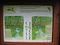
Sign board
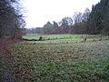
The meadow valley

