Westerholter Bach
|
Westerholter Bach ( Kirchbach ) |
||
|
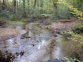
The confluence of the Westerholter Bach (middle) and Schnakenbach (left) shortly before the confluence with the Ölbach |
||
| Data | ||
| Water code | DE : 312842 | |
| location | North Rhine-Westphalia , Germany | |
| River system | Ems | |
| Drain over | Ölbach → Wapelbach → Dalke → Ems → North Sea | |
| source | Hirschquellen north of Stukenbrock 51 ° 55 ′ 20 ″ N , 8 ° 39 ′ 45 ″ E |
|
| Source height | approx. 160 m above sea level NN | |
| muzzle | In Stukenbrock in the Ölbach Coordinates: 51 ° 54 '40 " N , 8 ° 39' 5" E 51 ° 54 '40 " N , 8 ° 39' 5" E |
|
| Mouth height | 128 m above sea level NN | |
| Height difference | approx. 32 m | |
| Bottom slope | approx. 20 ‰ | |
| length | 1.6 km | |
| Catchment area | 5.683 km² | |
| Right tributaries | Schnakenbach | |
| Communities | Oerlinghausen , Holte-Stukenbrock Castle | |
The Westerholter Bach (also Kirchbach and according to the list of waters in the spelling Westerholterbach ) is an orographically right tributary of the Ölbach in North Rhine-Westphalia , Germany . It has a length of 1.6 km.
River course
The Westerholter Bach arises in the Senne just on the district of Oerlinghausen as an outflow from a pond north of Stukenbrock. This pond is also traversed by the Schnakenbach , is also fed by a nameless body of water and is known as deer springs .
Following the flattening of the Teutoburg Forest , the Westerholter Bach flows off in a south-westerly direction and is dammed after a few hundred meters for the purpose of fish farming. After crossing the breeding facility, the water flows through the Stukenbrocker settlement area, picks up the Schnakenbach in a forest below the cemetery and flows into the Ölbach just a few meters further.
Differences in classification
Some maps trace the assumption that the section of the Schnakenbach between its upper course and Hirschquellen is the continuation of the Westerholter Bach. The name of the nature reserve through which the Schnakenbach flows in this area, "Dry valleys, box valleys and dunes of the upper Westerholter Bach", also refers to this interpretation. The official geospatial material does not support this system.
Web links
- Nature reserve “Westerholter Bach” (LIP-017) in the specialist information system of the State Office for Nature, Environment and Consumer Protection in North Rhine-Westphalia
Individual evidence
- ↑ a b German basic map 1: 5000
- ↑ a b Water directory of the State Office for Nature, Environment and Consumer Protection NRW 2006 ( Memento from February 15, 2010 in the Internet Archive ) (PDF; 1.03 MB)
