Dalke
|
Dalke (upper course: Bullerbach ) |
||
|
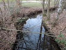
The Dalke north of Verl |
||
| Data | ||
| Water code | EN : 312 | |
| location | North Rhine-Westphalia , Germany | |
| River system | Ems | |
| source | In Sennestadt | |
| Source height | approx. 138 m above sea level NHN | |
| muzzle | At Gütersloh in the Ems Coordinates: 51 ° 54 '35 " N , 8 ° 18' 48" E 51 ° 54 '35 " N , 8 ° 18' 48" E |
|
| Mouth height | approx. 64 m above sea level NHN | |
| Height difference | approx. 74 m | |
| Bottom slope | approx. 3.1 ‰ | |
| length | 24 km with Bullerbach | |
| Catchment area | 245.559 km² | |
| Left tributaries | Wapelbach , Menkebach , Sprungbach , Strothbach | |
| Right tributaries | Hasselbach , Bekelbach | |
| Reservoirs flowed through | City pond, mill pond | |
| Big cities | Bielefeld | |
| Medium-sized cities | Gütersloh , Verl | |


The Dalke (also called Dalkebach , Bullerbach in the upper reaches ) is an approximately 24-kilometer-long right-hand tributary of the Ems .
River course
Upper course as Bullerbach
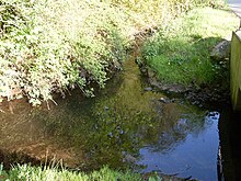
The source of the Dalke, known as Bullerbach in the upper reaches, is 138 meters above sea level in the Sennestadt district of Bielefeld . The body of water actually rises east of the Hellegrundsberg in the Lämershagen area , but seeps into the sand after a few hundred meters, like most of the streams that spring in the Teutoburg Forest after leaving the mountainous region. Since the impermeable layer of marl reaches the surface southwest of the Teutoburg Forest, the stream finally re-emerges in Sennestadt in an elaborately renatured spring.
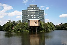
The Bullerbach flows in a near-natural brook valley in a south-westerly direction and is dammed in several places in the Sennestadt area. First, the water flows through the almost 8000 m² large park pond, then the 17,160 m² large city pond surrounding the Sennestadthaus district office, and finally another reservoir known as the mill pond.
The Bullerbach continues through Eckardtsheim , takes up the Sprungbach on the left and is called "Dalke" from this inlet.
Middle reaches to the city limits of Gütersloh
Southwest of Eckardtsheim the Dalke leaves the Bielefeld city area, enters the district of the city of Verl and takes shortly after the out Dalbke tapered Strothbach on. The water then leads north past the Sende district of Verler , crosses under federal motorway 2 and enters the Große Wiese nature reserve . After the Hasselbach and Bekelbach inflows were added within this grassland complex, the Dalke initially forms the city boundary between Verl and Gütersloh , then enters the Gütersloh district and flows through the urban area for almost exactly 15 kilometers.
Underflow to the mouth
South of the Avenwedde district , the Dalke takes on the Menkebach at the level of the strand mill . The water then crosses the Gütersloh inner city area running from east to west and forms an almost continuous green corridor, in the course of which, among other things, the Gütersloh city park with the park pool and the Riegerpark are passed. The Putzhagen sewage treatment plant , the central sewage treatment plant in Güterslohs, is located about two kilometers from the estuary . About one kilometer before it reaches the Ems (which marks the border between the town of Gütersloh and the municipality of Herzebrock-Clarholz ), the Dalke takes up the Wapelbach near the “Neue Mühle” in the Pavenstädt district .
Tributaries
The following overview lists the tributaries of the Dalke, viewed downstream:
| GKZ | Surname |
Length in km |
Catchment area in km² |
Mouth height in m above sea level NHN |
Location of the mouth |
| 3122 | Sprungbach | 4.064 | 7.460 | approx. 111 | left side |
| 31234 | Strothbach | 5.007 | <10 | approx. 103 | left side |
| 3124 | Hasselbach | 6.317 | 10.968 | approx. 90 | right side |
| 31252 | Bekelbach | 6,796 | <10 | approx. 84 | right side |
| 3126 | Menkebach | 20,130 | 14,704 | approx. 81 | left side |
| 3128 | Wapelbach | 35,494 | 164.836 | approx. 70 | left side |
history
The first written mention of the river comes from the year 1001. The "Dellina" or "Delchana" formed the border of the Paderborn forest ban . From the middle of the 18th century the Dalke was the customs border. During the time of the Kingdom of Westphalia , it formed the border between the village of Gütersloh, which belonged to the Grand Duchy of Berg , and the farmers of Kattenstroth (today a district of Gütersloh), which belonged to the Kingdom of Westphalia .
In the 19th century the course of the river was interfered with to a greater extent. While the Dalke was still characterized by numerous bends in the river around 1800 , the river showed almost the current course as early as 1897. In the years 1841, 1881 and 1946 the Dalke flooded the bank after storms and sometimes caused considerable damage to buildings in Gütersloh city center, including a. in the St. Elisabeth Hospital .
At the end of the 1960s, the river was straightened for flood protection reasons . The Dalke was widened from 2 to 6 meters and, as part of the regulation, was given a concrete bed in places so that it had a canal-like character, which many Gütersloh citizens perceived as a building sin . In the 1990s to the mid-2000s, the Dalke was renatured . A diverse habitat for the animal world developed again; with a cycling and hiking trail along its banks, the river serves as a local recreation area .
Further renaturation measures were also carried out in the area around the source in Sennestadt. After the source area of the Bullerbach was built with massive stone and concrete protection in the 1970s, a natural redesign was carried out in 2001, which was completed in autumn 2003 with the construction of a wooden walkway with a viewing platform.
Water quality
The Bullerbach is in the region of its Quelltals the water quality class I-II associated applies thus "lightly loaded" as making it one of the few water on Bielefeld urban area, which can have such a low load condition. The condition of the water quality deteriorates with the flow of the reservoirs, from this point on the quality class II-III applies and thus a critical load. Shortly before the confluence of the Sprungbach, however, quality class II is achieved again, which corresponds to a moderate load.
Numerous discharges into the Dalke meant that the quality of the water in Gütersloh's urban area had to be classified as heavily polluted in the 1980s (water quality class III). Today, however, the pollution status has improved again, the Dalke can be assigned to water quality class II - III in this area and is therefore classified as critically polluted.
The Dalke as a useful body of water
Water mills have been operated with water from the Dalke for centuries , eight of them in the area of the city of Gütersloh. However, the first system seen from the source is already in the south of Sennestadt. This is the winter mill; a former water mill that has now been converted into a hotel. However, the associated mill pond is still flowed through by the Bullerbach.
The easternmost Gütersloh mill is the Eikelmann mill, which is located south of the Große Wiese at the level of the city limits towards Verl. This grain mill has since been shut down, but the former 3,500 m² mill pond still exists. North of Sürenheide , the Dalke flows at the level of the mouth of the Bekelbach along the Ruthmann watermill, which was built in 1823 and modernized in 1951, a machine mill that is still functional and where the shot was still transported vertically via elevators and metal downpipes. About two kilometers downriver is the Strangmühle near Avenwedde, one of the oldest mills in Gütersloh, which was in operation at the beginning of the 18th century. However, the structure has not been in operation since the 1960s.
The Avenstroth mill is located at the level of the Parkbad in the Sundern district . This plant is a partially still functional grain mill; In addition, the Gütersloh mill, first mentioned in a document in 1532 and thus probably the oldest, has been used by the municipal utilities to generate electricity since 1953. Another former facility called Meiers Mühle can be found west of the city park , whose Kolk was used as Gütersloh's first outdoor swimming pool in the mid-19th century . The flour mill has ceased operations since the 1950s. Not far from the estuary, the Dalke finally leads past the Neue Mühle, which once served, among other things, to extract edible oil , but is no longer in operation and was previously used as a restaurant. The associated pond, on which the regionally famous bike race over water was held, has been preserved. Today (2018) the company and the associated lake are no longer used. But there are plans for a revival.
With Amtenbrink's mill and Barkeys mill, there were once two more mills in Gütersloh's urban area, but have since been demolished.
literature
- Detlef Güthenke, Susanne Zimmermann: Everything in flux. The renaturation of the Dalke in Gütersloh . Ed .: City of Gütersloh. Vox Rindvieh, Gütersloh 2019, ISBN 978-3-9820157-2-9 .
Web links
Footnotes
- ↑ a b c Topographic map 1: 25,000
- ↑ a b Topographical Information Management, Cologne District Government, Department GEObasis NRW ( Notes )
- ↑ a b Excerpt from the Bielefeld water quality report 2008 (PDF; 2.9 MB)
- ↑ a b c Water directory of the State Office for Nature, Environment and Consumer Protection NRW 2010 (XLS; 4.67 MB) ( Notes )
- ↑ Profile of the source in the Senne portal ( page no longer available , search in web archives ) Info: The link was automatically marked as defective. Please check the link according to the instructions and then remove this notice.
- ↑ Gütersloher "Neue Mühle" is to be revived. nw.de, July 21, 2018, accessed on January 12, 2019 .
- ↑ Gütersloh mills on the Dalke (guetersloh.de)

