Wapelbach
|
Wapelbach (upper course: Wehrbach ) |
||
|
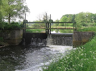
Weir in the Wapelbach near the Wapelbad near the Gütersloh district of Kattenstroth |
||
| Data | ||
| Water code | EN : 3128 | |
| location | East Westphalia , North Rhine-Westphalia , Germany | |
| River system | Ems | |
| Drain over | Dalke → Ems → North Sea | |
| source | At Stukenbrock 51 ° 54 ′ 11 ″ N , 8 ° 41 ′ 22 ″ E |
|
| Source height | approx. 150 m above sea level NN | |
| muzzle | Dalke mouth near Gütersloh Coordinates: 51 ° 54 ′ 15 " N , 8 ° 19 ′ 28" E 51 ° 54 ′ 15 " N , 8 ° 19 ′ 28" E |
|
| Mouth height | approx. 66 m above sea level NN | |
| Height difference | approx. 84 m | |
| Bottom slope | approx. 2.4 ‰ | |
| length | 35.5 km | |
| Catchment area | 164.836 km² | |
| Right tributaries | Ölbach , Knisterbach , Großer Bastergraben , Rodenbach | |
| Medium-sized cities | Holte-Stukenbrock Castle , Verl , Gütersloh | |
The Wapelbach , sometimes just called the Wapel and Wehrbach in the upper reaches , is a 35.5 km long, left-hand tributary of the Dalke and belongs to the Ems river system , so its water ultimately flows into the North Sea .
geography
The Wapelbach rises as a Wehrbach east of Stukenbrock near the former federal road 68 on the southeast slope of the Osningstrang of the Teutoburg Forest and crosses the Wehrbachtal nature reserve in its upper reaches . Only after about five kilometers does the water change its name to "Wapelbach", as such flows through the communities of Schloß Holte-Stukenbrock , Verl , Rietberg , Rheda-Wiedenbrück and Gütersloh (all in the district of Gütersloh ) and flows out near the "New Mill" “In the Gütersloh district of Pavenstädt in the Dalke, about a kilometer before this river flows into the Ems.
At Kaunitz , the Wapelbach takes on the Rodenbach on the right and flows there in a wide floodplain through the Grasmeerwiesen nature reserve . Then it flows through the Rietberg district of Neuenkirchen . In the vicinity of the Gütersloh district of Kattenstroth, it takes up the Ölbach on the right. Along the entire route of the flux flows mainly through agricultural land, but also by forest areas of the Teutoburgerwald upstream Senne landscape and Rhedaer Forst and by two reserves.
The Wapelbach is touristically connected to the European cycle route R1 , which runs about eight kilometers in the river area. The Wapelbach crosses under the important traffic arteries Federal Motorway 33 , Federal Motorway 2 , Federal Road 61 and the Hamm – Minden railway line .
environment
The Wapelbach flows through the 131 hectare wet meadow reserve Grasmeerwiesen, which has existed since 1989 . The designation as partially congruent Natura 2000 protected area according to the Fauna-Flora-Habitat Directive was later made under the name "Sennebächer" and was controversial.
Flora and fauna
In the course of the designation as an FFH area, the protected fish species brook lamprey and bullhead were identified . The priority habitats according to the criteria of the Habitats Directive are the alder, ash and softwood alluvial forests in the river area.
Water quality
The municipal sewage treatment plant of Schloß Holte-Stukenbrock drains into the water system of the Wapelbach.
Because of the poor water quality, especially in the lower course of the river, bathing in the adjoining Wapelbad was stopped in the 1960s and has not been reopened to this day.
The occurrence of the bullhead in the upper course of the river is, however, an indicator of a very high water quality in this area.
Sights and buildings
At the height of the Wapelbad a weir was built in the Wapelbach in 1933 in order to dammed up the water for bathing.
The pool, which was put into operation in 1925/26, was used as a swimming opportunity until the 1960s. Today bathing is only allowed in the paddling pool due to the poor water quality.
In the past, the Wapelbach tended to flood in the middle and lower reaches, especially in the winter months with high rainfall. For this reason, a retention basin was built in 2008 west of the Grasmeerwiesen .
swell
- ↑ a b German basic map 1: 5000
- ↑ a b Topographical Information Management, Cologne District Government, Department GEObasis NRW ( information ) (query on November 14, 2010)
- ^ "Grasmeerwiesen" nature reserve in the specialist information system of the State Office for Nature, Environment and Consumer Protection in North Rhine-Westphalia
- ↑ Expert opinion on behalf of the municipality of Schloß Holte-Stukenbrock (PDF, 672 KB)
- ↑ The District Administrator d. Detmold administrative district: Results of the review of the registration documents for the FFH area "Sennebächer" . Printed matter number 1827. November 6, 2006.

