Sprungbach
| Sprungbach | ||
|
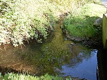
The Sprungbach near Eckardtsheim |
||
| Data | ||
| Water code | EN : 3122 | |
| location | North Rhine-Westphalia , Germany | |
| River system | Ems | |
| Drain over | Dalke → Ems → North Sea | |
| source | East of the Bielefeld district Sennestadt 51 ° 56 ′ 38 ″ N , 8 ° 36 ′ 23 ″ E |
|
| Source height | approx. 141 m above sea level NN | |
| muzzle | At Eckardtsheim in the Dalke coordinates: 51 ° 55 '48 " N , 8 ° 33' 32" E 51 ° 55 '48 " N , 8 ° 33' 32" E |
|
| Mouth height | approx. 107 m above sea level NN | |
| Height difference | approx. 34 m | |
| Bottom slope | approx. 8.4 ‰ | |
| length | 4.1 km | |
| Catchment area | 7.46 km² | |
| Big cities | Bielefeld | |
The Sprungbach is an orographically left tributary of the Dalke in North Rhine-Westphalia , Germany . The route of this largely natural and 4.1 km long Sennebach leads largely through nature reserves . While the upper course of the stream primarily crosses forest zones, the lower lowland area is predominantly grassland. Due to the low precipitation winters in recent years, the Sprungbach is drying up more and more often.
River course
The Sprungbach rises at a height of 148 meters within a forest area known as "Brakebrink" and in front of the actual Teutoburg Forest . The source of the brook has been dammed up into three successive, near-natural ponds, from which the Sprungbach flows into a box valley . This brook valley forms the “Sprungbach-Oberlauf” nature reserve, which is delimited by the crossing of the L 756 state road leading from Dalbke to Sennestadt .
Following the south-western flattening of the Teutoburg Forest, the water then reaches another area designated as a nature reserve called "Sprungbach-Mittellauf", passes the Bielefeld district of Sennestadt in the south and then crosses under the federal motorway 33 , which ends the protected area of the Bachaue.
Within the settlement area of Eckardtsheim , the Sprungbach finally flows on the left side into the Bullerbach, which changes its name from this tributary and is henceforth called Dalke .
The Sprungbach overcomes a height difference of 34 meters during its course of flow, resulting in an average bed gradient of 8.5 ‰.
NSG Sprungbach upper course
The "Sprungbach Oberlauf" nature reserve, designated with the area number BI-014, covers an area of around 7.6 hectares and forms a narrow spring valley that is cut deep into the surroundings and sometimes forms steep slopes . The three pent-up spring ponds are also included in the protected area. Stocks of sedges , reed beds and irises can be found on the banks of these ponds . The ponds are also an important spawning area for amphibians , the common frog in particular is found in large numbers.
Below the ponds there is a relatively young alder forest , which developed from a former wet meadow after its management was abandoned. To the southwest of this area follows an extensively managed grassland area with extensive Binsenried stands in the riparian zone. In the lower area of the protection area there is a smaller pond used for fish farming.
Due to the species-rich flora, the entire immediate protected area may not be entered.
NSG Sprungbach middle course
The middle course of the Sprungbach also forms an area designated as a protected area, which is listed with the area number BI-030 and covers around 12 hectares. Within the Bachaue, this zone, which is partially directly adjacent to settlement areas, forms a biotope network section . While the water near the settlement has been partially straightened, in the rest of the middle reaches it has developed naturally with bank and underwater vegetation. The clean water is the habitat of numerous fish species, including the brook lamprey , which forms a reproductive population.
In the further course of the protected area, in the bank area of the brook, which now shows a sandy bed typical of the Senne brooks, there is another quarry forest with sedge reeds, wet meadows and two natural smaller ponds.
environment
Due to the fact that large parts of the Sprungbach are under nature protection, it has a very positive water quality. The stream is assigned to water quality class II throughout its course and is therefore considered to be “moderately polluted”.
Individual evidence
- ↑ a b German basic map 1: 5000
- ↑ a b Topographical Information Management, Cologne District Government, Department GEObasis NRW ( Notes ) (Accessed November 7, 2010)
- ↑ ROMANS, U. & W. VENNE (1995): First evidence of Bach lamprey Lampetra planeri in the field of Bielefeld - Messages from the project "Fish of the Senne", in: Reports of the Natural Scientific Society Bielefeld and around 36, p 235 -245.
- ↑ Excerpt from the Bielefeld water quality report 2008 (PDF; 2.9 MB)
Web links
- "Sprungbach" nature reserve (BI-014) in the specialist information system of the State Office for Nature, Environment and Consumer Protection in North Rhine-Westphalia (BI-014)
- "Sprungbach" nature reserve (BI-030) in the specialist information system of the State Office for Nature, Environment and Consumer Protection in North Rhine-Westphalia (BI-030)


