Südkamp
|
Südkamp
|
|
|
Südkamp |
|
| location | North Rhine-Westphalia , Germany |
| surface | 9.2 ha |
| Identifier | BI-028 |
| WDPA ID | 344785 |
| Geographical location | 51 ° 57 ' N , 8 ° 33' E |
| Setup date | 2005 |
| administration | Lower landscape authority of the city of Bielefeld |
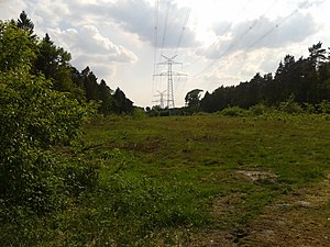
The Südkamp is a nature reserve with a size of 9.20 hectares in the Senne district of the city of Bielefeld . It is managed with the number BI-028. The area was designated as a nature reserve in 2005 and serves the preservation and development of Calluna and Erica heather and sandy grasslands as well as open sandy areas and their transition zones in the forest edge area on nutrient-poor sandy soils with their rare animal and plant species.
location
The protected area is located northeast of the Bielefeld motorway junction in the Senne district of Bielefeld. Although it is located within a forest area, the Senne-Bahn line and the Bielefeld substation south border the Südkamp in the south- west. On the north-west and south-east side, the protection area is bounded by a high-voltage line.
The Südkamp has a slope of about five meters on and follows the flattening of the Teutoburg Forest upstream Senne landscape , with the highest point at 125 meters above sea level. NHN is located in the northeast.
Individual evidence
- ^ "Südkamp" nature reserve (BI-028) in the specialist information system of the State Office for Nature, Environment and Consumer Protection in North Rhine-Westphalia , accessed on March 9, 2017.
- ↑ Topographical Information Management, Cologne District Government, Department GEObasis NRW ( Notes ) (query on April 4, 2013)

