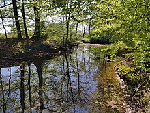
Beckendorfer Mühlenbach
| Beckendorfer Mühlenbach | ||
|
Beckendorfer Mühlenbach in Bielefeld. |
||
| Data | ||
| Water code | DE : 46422 | |
| location | North Rhine-Westphalia , Germany | |
| River system | Weser | |
| Drain over | Schwarzbach → Johannisbach → Werre → Weser → North Sea | |
| source |
Jöllenbeck 52 ° 6 ′ 14 ″ N , 8 ° 29 ′ 7 ″ E |
|
| Source height | approx. 143 m above sea level NHN | |
| muzzle | At Theesen in den Schwarzbach coordinates: 52 ° 4 ′ 1 ″ N , 8 ° 30 ′ 21 ″ E 52 ° 4 ′ 1 ″ N , 8 ° 30 ′ 21 ″ E |
|
| Mouth height | approx. 89.7 m above sea level NHN | |
| Height difference | approx. 53.3 m | |
| Bottom slope | approx. 8.5 ‰ | |
| length | 6.3 km | |
| Catchment area | 13.7 km² | |
| Left tributaries | Preckerbach (Dreeker Bach), Pfarrholzbach | |
| Big cities | Bielefeld | |
| Small towns | Spenge , Werther | |
The Beckendorfer Mühlenbach is a right tributary of the Schwarzbach in the northeast of the German state of North Rhine-Westphalia .
Geography and course
The water has a total length of 6.3 km. The catchment area extends over a small section of the Ravensberger Mulde in the north of Bielefeld , south of Spenge and east of Werther . The water rises in the Jöllenbeck area of the Nagelsholz and flows into the Schwarzbach near Theesen (river kilometer 0.4). The water flows through the following communities on its way from the source to the mouth:
The brook is temporarily border brook between Spenge, Werther and Bielefeld.
On its way, the water includes the following waters when viewed downstream:
|
Stat. in km |
Surname | GKZ | location | Length in km |
EZG in km² |
|---|---|---|---|---|---|
| 3.2 | Preckerbach (Dreeker Bach) | Left | |||
| 2.1 | Pfarrholzbach | Left |
Upper course
The Beckendorfer Mühlenbach rises in a spring pond at the height of Nagelsholz north of Jöllenbeck , around 750 m west of the street corner Nagelsholz / Schlottkamp and 500 m north of the Jöllenbeck wind turbine. The source area already belongs to the Beckendorfer Mühlenbachtal nature reserve , which accompanies the stream to its mouth. The brook flows around 1.2 km in a south-westerly direction through an alluvial forest, marking the border between Bielefeld and Spenge for around 300 m, and crosses under the Bargholzstrasse between Jöllenbeck and Häger . On the south side of the road, remains of the former Jöllenbeck outdoor pool can still be seen in the alluvial forest. The stream turns here to the south and forms the border between Bielefeld and Werther for over 1 km. He passed an elongated rubble dump to the west. From here, the stream flows mainly through a box-shaped sieve typical of the Ravensberg hill country . 700 m south of Bargholzstrasse, a nameless tributary flows into it from the right, and another nameless tributary 400 m further south.
Middle course
The middle course turns to the southeast. 700 m further southeast, the Dreeker Bach or Preckerbach flows from the left, which rises on Dreeker Weg in Jöllenbeck. The largest part of this side valley is part of the nature reserve. Another 700 m to the south-east the brook crosses under Beckendorfstrasse between Jöllenbeck and Schröttinghausen . There was a fish pond in the curve of the road, which has now largely silted up. 400 m further southeast the Pfarrholzbach joins from the left , which rises at the Breede in Jöllenbeck. At the mouth there was a mill that is still used as a house. 500 m further south, below the Heidsieker Heide street with a hotel building that can be seen from afar, another nameless stream joins from the right. Before that, the stream passes Haselhorst farm to the east and a riding facility to the west. Another 400 m further south, the Horstheider Bach flows from the left, which rises at the northern end of Theesen .
Lower course
The approximately 1 km long lower course moves with a few curves in a narrow alluvial forest almost in a north-south direction, which separates Theesen from Babenhausen . Shortly before its confluence with the Schwarzbach, the Beckendorfer Mühlenbach passes under the hiking trail that leads from the Köckerhof to the other Hof Meyer zur Müdehorst on Schröttinghauser Straße.
environment
Large parts of the Bachtal are under nature protection. The Beckendorfer Mühlenbachtal nature reserve is looked after by the Biological Station Gütersloh / Bielefeld and serves, among other things, to "protect the largely contiguous valley areas of the Beckendorfer Mühlenbach from the source to the confluence with the Schwarzbach and the Seitensieke".
fauna
The nature reserve is known for the occurrence of the kingfisher , the small woodpecker and the crested newt .
See also
Web links
Individual evidence
- ↑ a b c d GeoServer NRW, State Office for Data Processing and Statistics NRW
- ^ "Beckendorfer Mühlenbachtal" nature reserve in the specialist information system of the State Office for Nature, Environment and Consumer Protection in North Rhine-Westphalia , accessed on February 23, 2017.


