Westheim (Biebelried)
|
Westheim
community Biebelried
|
|
|---|---|
| Coordinates: 49 ° 44 ′ 40 ″ N , 10 ° 3 ′ 54 ″ E | |
| Height : | 295 m |
| Residents : | 123 |
| Incorporation : | May 1, 1978 |
| Postal code : | 97318 |
| Area code : | 09321 |
|
Location of Westheim (bold) in the Biebelried municipal area
|
|
Westheim is a district of the municipality of Biebelried in the Lower Franconian district of Kitzingen .
Geographical location
Westheim is located in the southwest of the municipality of Biebelried. The district of Biebelried joins in the north and the large district town of Kitzingen extends to the east . The district of Kaltensondheim is located southeast of Westheim , and the district of Würzburg is located in the southwest and west . The chestnut in front of the Westheim town hall is classified as a natural monument .
The nearest, larger cities are Kitzingen, about 7 kilometers away, and Würzburg , about 10 kilometers away.
In terms of nature, Westheim is located on the so-called plateaus in the southern Main Triangle , which are counted among the Gäuf areas in the Main Triangle. Typical are the approximately 300 m high areas that slope steeply towards the Main.
history
Westheim was first mentioned in a document in 1167. The foundation probably took place during the Frankish conquest in the first Christian centuries. From 1498 to 1731 the Limpurg taverns ruled the village. It was not until the 18th century that the Würzburg cathedral chapter was able to take power over Westheim. In the 19th century the farming village of Westheim became a Bavarian rural community , and in 1978 it became part of the Biebelried community.
coat of arms
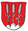
| Blazon : "In red three silver ears of cereal growing from a silver mountain on upright stalks." | |
| Justification of the coat of arms: The coat of arms is borrowed from an official seal from 1638. The tinging probably refers to centuries of membership in the Würzburg monastery, whose coat of arms also has the colors red and silver. The ears of wheat are perhaps an indication of the main occupation of the residents. |
Attractions
The village's Evangelical Lutheran parish church was built in 1893/1894 when the dilapidated fortified church was demolished. The altars can be assigned to the so-called carpenter's Gothic. Several wall frescoes decorate the interior of the church, in the ceiling fresco you can see the representation of the young Jesus in the Jerusalem temple.
In addition to the church, there are several farmhouses and farms in the village, which can be attributed to the late 18th and early 19th centuries. The cemetery has tombs from the same period. The former castle of the barons Groß von Trockau is now integrated into an agricultural property and can hardly be recognized.
literature
- Hans Bauer: Old and new coats of arms in the Kitzingen district. In: Yearbook of the district of Kitzingen 1980. In the spell of the Schwanberg. Kitzingen 1980. pp. 53-70.
- Hans Bauer: District of Kitzingen. An art and culture guide. Market wide 1993.


