Wieden (Regnitzlosau)
|
Wieden
community Regnitzlosau
Coordinates: 50 ° 19 '22 " N , 12 ° 5' 44" E
|
|
|---|---|
| Height : | 553 m |
| Residents : | 0 (2018) |
| Postal code : | 95194 |
| Area code : | 09294 |
Wieden is part of the municipality of Regnitzlosau in the Upper Franconian district of Hof .
Geographical location
The wasteland is located 4 km northwest of Regnitzlosau, directly on the border of the federal states of Bavaria and Saxony and thus on the former inner-German border not far from the border triangle FRG-GDR-Czechoslovakia . A connecting road leads from Nentschau via Zech to Wieden and on to Mittelhammer , Oberzech and Prex .
history
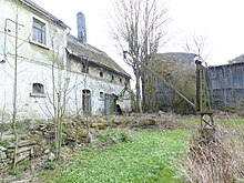
Until the division of Germany and the progressive expansion of the German-German border , there were the places Oberwieden and Unterwieden. These belonged to the municipality of Tiefenbrunn , today part of Eichigt . The farm that still exists today is the part of Unterwieden that remained on the Bavarian side. The rest of the village was on the territory of the German Democratic Republic and was demolished in 1961. The windows and doors of the buildings in Oberwieden were initially bricked up and finally shared the fate of Unterwieden in 1974. The majority of the residents fled the GDR to neighboring Bavarian villages at an early stage.
A medieval stone cross near the Steinseifelbächlein is under monument protection .
Web links
- Bavarian premiere in the BayernAtlas ( online )
Individual evidence
- ↑ Soviet zone combat groups roll down farmsteads in the Rehau border area and German tragedy at the zone border - houses are razed to the ground , article in the Frankenpost of Saturday, September 2, 1961
- ↑ Three kilometers further, into a completely different world , article in the Frankenpost from Saturday, May 29, 2002

