
Paulinenhof housing estate


The Paulinenhof housing estate is an extensive complex in Frankfurt (Oder) in the style of older garden cities, which was created in the 1920s based on designs by Martin Kießling . The settlement was created in the Nuhnenvorstadt to accommodate 300 families of employees of the Reichsbahndirektion Osten , which was moved to Frankfurt as a result of the First World War. The complex consists of one- and two-story single-family houses and several apartment buildings and is a listed building .
location

The settlement is located in Frankfurt (Oder) -West in the Nuhnenvorstadt district , west of the railroad tracks of the freight station. It is bordered by August-Bebel-Strasse in the north and northeast, Georg-Friedrich-Handel-Strasse in the west and the Nuhnenfließ in the south and southeast. The settlement includes: Albert-Fellert-Strasse, Albert-Lortzing-Strasse, Franz-Liszt-Ring, Georg-Friedrich-Händel-Strasse, Harfenweg, Hermann-Boian-Strasse, Joseph-Haydn-Strasse, Kießlingplatz, Paulinenhof and Peter- Tchaikovsky ring.
history
prehistory
After the end of the First World War , Germany lost territories in the east under the provisions of the Versailles Treaty . That is why the railway directorates in Poznan , Bromberg and Danzig were dissolved and merged in Berlin as the " Reichsbahndirektion Osten ". A little later the head office was relocated to Frankfurt (Oder). In the course of this, living space had to be created for more than 600 families. The Reichsbahndirektion founded the "Siedlungsgesellschaft Ostmark mbH" together with the city of Frankfurt (Oder). On the one hand, the construction projects could be operated in a private sector. On the other hand, the future residents had an extensive right of co-determination on the location and furnishings of the buildings via the supervisory board. The main costs were borne by the Reichsbahnverwaltung. The Ministry of Welfare contributed 80,000 gold marks . The city of Frankfurt primarily made cheap building land available. The Reichsbahndirektion was housed in the building complex of the Leibgrenadier barracks on the Oder. Few plots were available in the densely built-up city. That is why construction was carried out at several locations: on the part of the Angers (Gertraudenplatz 1–5) adjacent to the Gertraudkirche, between Wiecke and Kleiststraße (today Franz-Mehring-Straße), between Grüner Weg and Bergstraße (Karl-Sobkowski-Straße), in Humboldtstrasse 15–20, in Leipziger Strasse 196 ff. (“Kießlingbauten”), in Ferdinandstrasse 16, on the station forecourt and on the grounds of the Paulinenhof estate.
Construction work from 1922 to 1925
The Paulinenhof housing estate was built between 1922 and 1925 as a settlement of the Ostmark GmbH settlement company. The Paulinenhof lease acquired by the city in 1910 served as the site. Apartments for more than 300 families were built. The designs came from Martin Kießling with the collaboration of the architects Artur Hauck and Heinrich Rosenthal. The architectural decoration was designed by the sculptor Waldemar Lemke. The execution was carried out by Philipp Holzmann AG , Berlin branch.
Structural changes after 1925
From 1925 to 1929, seven residential buildings with 17 officers' apartments were built in Dirschauer Strasse 9–15 (today Georg-Friedrich-Händel-Strasse), built by Wohnbau GmbH Berlin based on designs by the Jockel government building council on behalf of the army administration. After that, execution of Kießling's original plans would have required considerable rescheduling. Therefore, an extension planned by Martin Kießling to Gerhart-Hauptmann-Straße was not pursued any further. The houses Dirschauer Strasse 14 and 15 were destroyed in 1945 at the end of the Second World War and later demolished.
Between 1977 and 1982 three two-story semi-detached houses were built at Georg-Friedrich-Händel-Strasse 29 a – f without any architectural reference to the surrounding buildings.
At the end of the Second World War, the "Herrenhausgruppe" and the associated square at the junction of Joseph-Haydn-Strasse and Franz-Liszt-Ring, a twin house at the western end and twelve row houses at the eastern end of Joseph-Haydn-Strasse were destroyed.
Protected position
The settlement was placed under monument protection on October 20, 1993 by a monument area statute of the city of Frankfurt (Oder). From 1996 the buildings were privatized. Many of the 344 apartments in the area were vacant at that time due to the poor state of construction. The railway had owned them since they were built. In order to make clear guidelines for upcoming structural changes, a design statute was put into effect in 1999 as a supplement to the monument area statute.
Street names
Most of the original street names refer to West Prussian cities that belonged to the disbanded railway departments, whose employees were settled in Frankfurt (Oder). After the end of the Second World War, these streets were renamed because after the Oder-Neisse border was established, references to former German and now Polish cities were politically undesirable. These streets were named after composers with reference to the music home to the west of the settlement . The settlement includes: Albert-Fellert-Strasse (formerly Danziger Strasse, named 1923, renamed in 1948 after the Frankfurt merchant who was persecuted as a communist and a Jew by the National Socialists and died in the Warsaw Ghetto in 1943), Albert-Lortzing- Strasse (formerly Culmer Strasse, named 1922, renamed 1953), Franz-Liszt -Ring (formerly Bromberger Ring, named 1923, renamed 1953), Georg-Friedrich-Händel- Strasse (formerly Dirschauer Strasse, named 1923, renamed 1953), Harfenweg (formerly Graudenzer Weg , named 1923, renamed 1953), Hermann-Boian-Strasse (formerly Ostmarkstrasse, named 1923, renamed in 1948 after the Frankfurt skipper, who was persecuted as a Bible researcher and opponent of the war by the Nazis and murdered in 1940 in the Sachsenhausen concentration camp), Joseph-Haydn- Strasse (formerly Thorner Grund, named 1923, renamed 1953), Kießlingplatz, Paulinenhof and Peter-Tschaikowski -Ring (formerly Posener Ring, named 1923, renamed 1953).
Building description
The area forms a flat hilltop stretching in an east-west direction with the highest point west of the facility at the Theaterteich. The extensive housing estate was laid out symmetrically in the style of older garden cities . The layout of the settlement shows the planned city, but is loosened up by numerous different plot sections. In addition, existing buildings had to be taken into account. There were already several detached houses along August-Bebel-Straße and a four-story rental apartment building was already in place at the confluence of Albert-Fellert-Straße with August-Bebel-Straße.

Two figure-crowned portals emphasize the main entrance on Kießlingplatz in the east. A western entrance with a monumental gatehouse is located on the central round square at the intersection of Albert-Fellert-Straße and Hermann-Boian-Straße. In between lies the main road axis with curved roads branching off to the side. All streets are lined on both sides with one to two-story plastered buildings. The buildings mostly have hipped roofs or saddle roofs with dormers in two designs. Their simple exterior is characterized by strong colors in red, green or blue with white window frames. The houses for two to eight families, including the commercial annexes and allotment gardens arranged in a fan shape, were effectively grouped into “picturesque” squares and streets. Small sculptures and plaster reliefs of the door frames in the conception of the Heimatschutz style come from the sculptor Waldemar Lemke.

The oldest building in the complex is the administrator's house for the municipal property. House Paulinenhof 1 and 2, presumably built in the 19th century, was radically changed in 1924.
Several different house types have been implemented in the housing estate.
| designation | description | Locations | Layout | Sample photo |
|---|---|---|---|---|
| 2 | single-storey, as the end of two-storey rows of terraced houses | Albert-Fellert-Strasse, Peter-Tschaikowski-Ring |

|

|
| 3 | single storey, terraced house or semi-detached house or completion of a row of terraced houses | Georg-Friedrich-Händel-Strasse, Franz-Liszt-Ring, Albert-Lortzing-Strasse |

|

|
| 4th | single storey, semi-detached house or one storey, chain house link | Semi-detached house: Joseph-Haydn-Straße (north side), Harfenweg; Chain house link: Hermann-Boian-Straße, Harfenweg, Joseph-Haydn-Straße (south side, closing houses) |

|

|
| 4 ' | single storey, chain house link | Joseph-Haydn-Strasse (south side) |

|

|
| 5 and 6 | two-storey, terraced house | Albert-Fellert-Strasse, Peter-Tschaikowski-Ring, Georg-Friedrich-Handel-Strasse |

|

|
| Apartment building | very different with three main types | Kießlingplatz, Hermann-Boian-Strasse, northern Georg-Friedrich-Händel-Strasse |

|
The house types were built according to local conditions as straight or curved row house groups, detached semi-detached houses or as chain houses. Chain houses are rows of houses in which duplex houses are connected to form a chain of houses by means of stable extensions.
Striking buildings are the "Torhausgruppe" on the round square, the "Tower House" with a sundial to cover an already existing multi-family house during the construction, the "Gatekeeper houses" at the entrance of Joseph-Haydn-Straße and the war-destroyed "Herrenhausgruppe" at the bend of the Joseph-Haydn- Street.

“Gatekeeper houses” in Joseph-Haydn-Straße

"Tower house" with sundial in Albert-Fellert-Straße
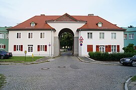
"Torhausgruppe" at the central round square


The Hermann-Boian-Straße as the central axis that rises with the terrain flows into a large round square in the middle of the garden city, which is divided into children's playgrounds and horticultural facilities. Hermann-Boian-Strasse is planted with a double row of linden trees on the narrow sections. In the western, wider part there are four rows of chestnuts. The round square is characterized by a row of robinia. Of the distinctive individual trees planned by Kießling, only one walnut tree still exists at the crossing Franz-Liszt-Ring / Hermann-Boian-Straße. Small-crowned fruit trees predominate in the private areas.
The house gardens are 200 to 400 m² in size. In the case of single-family houses, the garden is directly connected to the house; in the case of multi-family houses, it is so that it can be seen from the windows of the apartment, if possible. Smaller gardens, for which corner solutions were sometimes necessary, were supplemented by leased land nearby.
Appreciation
“In the early days of the Weimar Republic, the 'Paulinenhof' factory estate in Frankfurt an der Oder (1922/24) of the East German Railway Directorate also stands out. It is less impressive for its architectural reference to the Prussian 18th century than for its urban development, which the architect Martin Kießling developed along a central axis. With the tip of their triangular shape aligned to the city, concave and convex curved streets of different radii set counterpoints to the rigid longitudinal axis and, in their juxtaposition of nature and human habitation, reveal the proximity to the English crescents of the 18th century in Bath. Its architect, John Wood the Younger, wrote the first architectural theoretical treatise on workers' housing in 1781 and thus had a considerable influence on housing construction in the 20th century. Dealing with the topographical conditions also reflects the theoretical thoughts of AE Brinckmann, whose book 'Platz und Monument als Künstlerisches Formproblem' was published in its third edition in 1923: 'Today, however, one goes more than before to the suggestions that the soil offers, in his stylization in urban planning, one is more naturalistic. '"
"The (...) monument area is placed under protection because an urban-artistic situation that is unique for the Mark Brandenburg in terms of structure and appearance has been preserved. (...) For the development of the city of Frankfurt (Oder), this settlement (...) is of local historical importance, as it was created in a time of economic recession and set new, previously unknown accents in rental housing in the city. (...) The distribution, layout and furnishing of the houses, which corresponded to the needs of the residents for keeping small livestock and garden space on the one hand and the latest standard of living comfort, especially the sanitary facilities, on the other hand, is of social historical importance. "
literature
- Martin Kießling: Site and urban development in Frankfurt ad Oder. In: Zeitschrift für Bauwesen , Volume 74, 1924, Hochbauteil, Issue 7–9, pp. 51–75. ( Digitized at the Central and State Library Berlin )
- Martin Kießling: Ostmark buildings. Urban development in a medium-sized town. Verlag Julius Hoffmann, Stuttgart 1925. (New edition as CD-ROM edition from the Frankfurt City Archives, Frankfurt (Oder) 2004)
- Hugo Althoff : The Ostmark buildings in Frankfurt ad Oder. In: Deutsche Bauzeitung , 59th year 1925,
- Sybille Gramlich, Andreas Bernhard, Andreas Cante, Irmelin Küttner (arrangement): Frankfurt (Oder). (= Monument topography Federal Republic of Germany , monuments in Brandenburg , volume 3.) Wernersche Verlagsgesellschaft, Worms 2002, ISBN 3-88462-190-4 , pp. 310-312.
- Dirk Bloch, Carsten Seifert: City of Frankfurt (Oder). Paulinenhof garden settlement. Urban planning framework . Expert opinion on behalf of the City of Frankfurt (Oder) - City Planning Office. 2004 ( Online [PDF; 7.0 MB ; accessed on July 9, 2016]).
Web links
Individual evidence
- ↑ Kießling 1924 pp. 51-55
- ↑ Althoff 1925 No. 93, p. 733
- ↑ Althoff 1925 p. 737
- ↑ Gramlich, Bernhard, Cante, Küttner 2002 p. 310
- ↑ a b c Bloch, Seifert 2004 p. 4
- ^ Statutes for the monument area Paulinenhofsiedlung (historical garden settlement) in Frankfurt (Oder). (PDF; 1.35 MB) (No longer available online.) In: www.frankfurt-oder.de. September 21, 2010, archived from the original on July 11, 2016 ; Retrieved July 11, 2016 . Info: The archive link was inserted automatically and has not yet been checked. Please check the original and archive link according to the instructions and then remove this notice.
- ↑ Statutes of the city of Frankfurt (Oder) on the local building regulations for the design of the Paulinenhof garden settlement (design statutes). (PDF; 7.66 MB) In: www.frankfurt-oder.de. May 26, 1999, accessed July 11, 2016 .
- ↑ Kießling 1924 p. 57
- ^ Matthias Noell: Forms of Modernity. New building in the state of Brandenburg. (PDF) In: archiv.ub.uni-heidelberg.de. P. 12 , accessed on July 21, 2016 (special print from Modernes Bauen between 1918 and 1933 ).
- ^ Statutes for the monument area Paulinenhofsiedlung (historical garden settlement) in Frankfurt (Oder). (PDF; 1.35 MB) (No longer available online.) In: www.frankfurt-oder.de. September 21, 2010, archived from the original on July 11, 2016 ; Retrieved July 11, 2016 . Info: The archive link was inserted automatically and has not yet been checked. Please check the original and archive link according to the instructions and then remove this notice.
Coordinates: 52 ° 20 ′ 40 ″ N , 14 ° 31 ′ 16 ″ E