Wolski forest
| Wolski forest | ||
|---|---|---|
| View from the A4 | ||
|
|
||
| Location: | Lesser Poland , Poland | |
| Specialty: | Forest | |
| Next city: | Krakow | |
| Surface: | 419 ha | |
| Wolski Forest in 1860 | ||
| View from the Vistula | ||
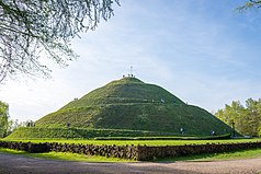
| Piłsudski Hill | ||
| View from the forest to the south | ||
The Wolski Forest (Polish: Las Wolski ) is a forest area in the urban area of Krakow . The Wolski Forest is located west of the city center between the western ring road and airport in the west and the city center in the east, north of the Vistula in a triangle of the districts Chełm , Bielany and Przegorzały , on the Sowiniec ridge , the southernmost branch of the Kraków-Częstochowa Law .
history
The forest owes its name to Mikołaj Wolski , who wanted to buy the forest from Sebastian Lubomirski for the foundation of the Camaldolese monastery around 1600. When the latter refused to sell the forest several times, Wolski invited Lubomirski and numerous other guests from the royal court to a festival at which he described his plans and at the end asked Lubomirski for the forest. Under these circumstances, he could no longer refuse and gave Wolski the forest for the purpose of the foundation. In return, Wolski gave him the silver dishes that were used for the feast. After this event, the monastery mountain in the Wolski forest was named Silberberg .
In 1917 the City of Krakow bought Wolski Forest (340 ha). On July 6, 1929, the Krakow Zoological Garden was opened there.
geography
There are numerous wooded mountains in the forest, of which the Sowiniec is the highest at 393.6 meters above sea level (with Piłsudski Hill ). There are numerous karst phenomena such as gorges, caves, rock formations - which are typical of the Jura. There are vineyards on the southern slopes, of which the Silberberg vineyard is the largest and best known.
The forest serves as a recreational area for the Krakow people. It has about 40 km of marked hiking trails.
- ▬ Chełm - Piłsudski Hill - Krakow Zoological Garden - Polana pod Dębiną - Bielany (Waterworks)
- ▬ Salwator - Kościuszko Hill - Sikornik - Panieńskie Skały - Piłsudski Hill - Zakamycze - Kryspinów
- ▬ Wola Justowska (al. Kasztanowa) - Panieńskie Skały - Wolski Dół - Krakow Zoological Garden - Łupany Dół - Polana pod Dębiną
- ▬ Przegorzały - Krakow Zoological Garden
- ▬ Piłsudski Hill - Polana pod Dębiną - Kozie Nogi - Cracow Zoological Garden
- ▬ Wola Justowska - Sikornik - Kozie Nogi
- ▬ Wola Justowska (al. Kasztanowa) - Krakow Zoological Garden - Zakamycze
- ▬ Polana pod Dębiną - Bielańskie Skałki - Bielany (Silberberg)
The path of the forts of the Kraków Fortress also runs through the Wolski Forest .
Excursion destinations
The following destinations are in the Wolski Forest:
as well as the nature reserves:
At the edge of the forest are
swell
Web links
Individual evidence
- ^ Małgorzata Klimas, Bożena Lesiak-Przybył, Anna Sokół: Wielki Kraków. Rozszerzenie granic miasta w latach 1910–1915 [Greater Krakow. Expansion of the city borders in the years 1910-1915] . Archiwum Państwowe w Krakowie, Kraków 2010, ISBN 978-83-927658-2-0 , p. 322 (Polish, English, online ).


