Woogbach (Speyerbach)
| Woogbach | ||
|
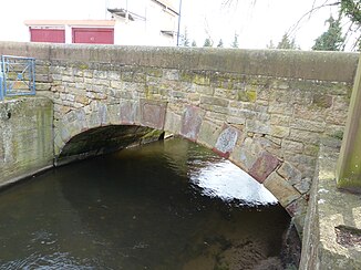
Sandstone bridge over the Woogbach in Hanhofen |
||
| Data | ||
| Water code | DE : 237896 | |
| location | Germany | |
| River system | Rhine | |
| Drain over | Speyerbach → Rhine → North Sea | |
| origin | Separation in Hanhofen to the left of the Speyerbach 49 ° 18 ′ 49 ″ N , 8 ° 20 ′ 6 ″ E |
|
| Source height | 107 m above sea level NHN | |
| muzzle | in Speyer from the left back into the Speyerbach Coordinates: 49 ° 19 '9 " N , 8 ° 26' 24" E 49 ° 19 '9 " N , 8 ° 26' 24" E |
|
| Mouth height | 94 m above sea level NHN | |
| Height difference | 13 m | |
| Bottom slope | 1.4 ‰ | |
| length | 9.1 km | |
| Catchment area | 63.7 km² | |
| Left tributaries | Altwiesenbach | |
| Right tributaries | Hainbach | |
| Medium-sized cities | Speyer | |
| Communities | Hanhofen , Dudenhofen | |
The Woogbach , called Nonnenbach on the lower course , is a good 9 km long flowing water in Rhineland-Palatinate and a left branch of the Speyerbach , from which it draws its water and into which it flows back again. The stream flows along its entire length in the Vorderpfalz .
Course and tributaries
The Woogbach does not have its own source , but separates at 107 m above sea level. NHN on the western edge of Hanhofen , at the so-called Hanhofer Wassergescheid , from the Speyerbach with half its water volume to the left. In a largely easterly direction it flows through Hanhofen and Dudenhofen before reaching Speyer . There it flows in a large curve to the right through an approximately 2.5 km long green belt . It then flows back into the Speyerbach from the left in front of the Mittelsteg road bridge at a height of 94 m , which in turn reaches the Rhine after another 800 m .
In addition to the Speyerbach itself, the Woogbach has two main sources of water: A left tributary is the 5 km long Altwiesenbach , which initially crosses under the Woogbach on the western edge of Dudenhofen to the left and flows into it after 500 m from the left. 200 m below this point, also in Dudenhofen, the strongest tributary flows from the right, the 33.6 km long Hainbach . Both mouths are a few meters south and north of the federal highway 39 , which leads from Speyer to Neustadt an der Weinstrasse .
traffic
One after the other, the Woogbach crosses under the B 39 in Dudenhofen, west of Speyer the A 61 ( Hockenheim - Mönchengladbach ) and within the city the Schifferstadt-Wörth railway line . Shortly before it merges with the Speyerbach, the Woogbach flows right past the Helmut Bantz Stadium .
Individual evidence
- ↑ a b Map service of the landscape information system of the Rhineland-Palatinate Nature Conservation Administration (LANIS map) ( notes )
- ↑ a b GeoExplorer of the Rhineland-Palatinate Water Management Authority ( information )

