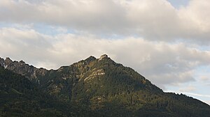
Zahnheilspitz
| Zahnheilspitz or Wisle | ||
|---|---|---|
|
In front, with a sharp break off, the Gurtisspitze, called the Zahnheilspitz or Wisle in the back |
||
| height | 1778 m above sea level A. | |
| location | between the market towns of Frastanz and Nenzing in Vorarlberg , Austria | |
| Mountains | Rätikon ( Galina Group ) | |
| Coordinates | 47 ° 10 '50 " N , 9 ° 37' 53" E | |
|
|
||
| Development | trail | |
| Normal way | Hiking trail from Gurtis - Bazora - Gurtisspitze - zäwasheilspitz or zäwasheilspitz - Gurtis - Sattelalpe | |
|
Bazora, Gurtisspitze, Zahwasheilspitz (Wisle) and the rest of the Galina group (Kamm) as seen from Amerlügen . |
||
A mountain in the Rätikon , part of the so-called Galina group , is referred to as the zäwasheilspitz (also: zäwasheilspitze or zewas-Heilspitze , 1778 m above sea level , partly also indicated as 1770, 1773, 1777, 1784 m above sea level ) , which is located in the municipality of Frastanz and Nenzing .
Surname
Zahnheilspitz is a combination of the greetings : Zawas and Heil und -spitz . Tough! or Zewas! is used in the region as a generally applicable greeting by the population in the sense of hello everyone! or hail together! but also hello! used. This may be derived from: Servus ! in Seawas! too zew! / Zewas! . Salvation! in this context means something like greet you! or lucky you! (see also: Berg Heil ). The supplement -spitz is used in this context for the mountain peak .
Werner Vogt has documented the parcel with Wisle in his extensive work: Vorarlberger Flurnamenbuch in this area .
It has not been clarified whether the zäwasheilspitz (Wisle) actually has to be viewed as an independent summit or as a double summit together with the Gurtisspitze , which is only 170 m away as the crow flies . In official works, the name zäwasheilspitz or zäwasheilspitze does not appear, but is used among hikers. The inscription on a plaque by the privately built summit cross reads: zwas Heil Bergheil .
location
The Zahnheilspitz (Wisle) is a striking elevation of the Galina Group (also: Galingrat), next to the Gurtisspitze, in the Rätikon. The foothills of the Galina group stretch to the market town of Frastanz (one of the last elevations is the Stutzberg ).
The vegetation consists of dense grass and some shrubs and fir trees etc. The summit is partly free of vegetation and offers an excellent all-round view.
Adjacent peaks and notches or Alps
Seen in a north-easterly direction, about 170 m as the crow flies, are the Gurtisspitze ( 1778 m above sea level ) In a south-westerly direction (700 m as the crow flies) the Spitztälispitz (about 1730 m above sea level ), a little off the ridge then the Goppaschrofen ( 1781 m above sea level ). The Sattelalpe ( 1383 m above sea level ) is about 900 m as the crow flies, the Hohen Köpf is about 1700 m ( 2040 m above sea level (with summit cross) and 2066 m above sea level ) away.
To the northwest, about 1700 m as the crow flies, is the Gavadura-Alpe, about 850 m as the crow flies to the north , the Bazora- Alpe (about 1416 m above sea level ).
hike
The Gäwasheilspitz (Wisle) can be easily reached via relatively good hiking trails and is only a few meters away from the main hiking trail. With sufficient personal condition can in a day of Gurtis the Gurtisspitze that Zäwasheilspitze (Wisle) Spitztälispitz which Goppaschrofen and the chief heads and the saddle Alpe committed Coming or be achieved (the tour of the Hohe heads because of the rocky, challenging road , partly secured with wire ropes, only recommended for experienced, sure-footed hikers).
The closest hiking base is the Sattelalpe (only open in summer). Other surrounding Alps are also only cultivated in summer. The Zahnheilspitz (Wisle) itself requires surefootedness and a head for heights as well as very good footwear and can be climbed with mountain experienced children.
- Time expenditure (examples)
- From Gurtis via the Bazora-Alpe to the Gurtisspitze and zäwasheilspitz (Wisle) with descent via Spitzwiesle to the Sattelalpe back to Gurtis ( 904 m above sea level ): Walking time: 4 ½ to 5 ½ hours.
- Gurtis over the Bazora-Alpe to the Gurtisspitze, zäwasheilspitz ( Wisle ), Spitzwiesle, Spitztälispitz, Hohe Köpf, Galinaalp, Sattelalp, Gurtis: walking time: about 8 to 12 hours
Summit cross
The summit cross was erected privately by Erich DeCet, M. Kuster, C. Lanbach. The inscription on the cross section of the summit is: Maria Hilf and on the longitudinal section: 2006 . The summit cross can be illuminated.
Web links
Individual evidence
- ↑ Classification according to the Alpine Club Leader Rätikon and named after the Galinakopf ( 2198 m above sea level ). Referred to as Galinagrat on the official Swiss map ( maps.admin.ch ).
- ↑ Not to be confused with the Gafadurahütte in Planken on Alp Gafadura at 1,428 m above sea level. M. in Liechtenstein .
- ↑ According to the information board at the summit cross.
- ↑ See: zwas-Heil Spitze , youtube.com, October 11, 2018.


