Zat (river)
| Oued Zat | ||
|
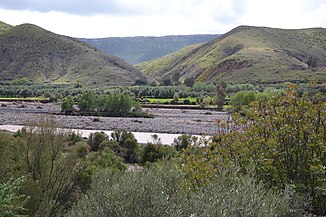
Lower reaches of the Oued Zat near Aït Ourir |
||
| Data | ||
| location | SW Morocco | |
| River system | Tensift | |
| Drain over | Ourika → Tensift → Atlantic | |
| source | in the High Atlas 31 ° 10 ′ 1 ″ N , 7 ° 40 ′ 10 ″ W |
|
| Source height | approx. 2500 m | |
| muzzle | approx. 30 km northeast of Marrakech in the Oued Ourika Coordinates: 31 ° 40 ′ 4 ″ N , 7 ° 51 ′ 24 ″ W 31 ° 40 ′ 4 ″ N , 7 ° 51 ′ 24 ″ W |
|
| Mouth height | approx. 550 m approx. | |
| Height difference | approx. 1950 m | |
| Bottom slope | approx. 24 ‰ | |
| length | 82 km | |
| Catchment area | 1500 km² | |
| Medium-sized cities | Ait Ourir | |
| Small towns | Azgour | |
The approximately 82 km long and at times dry falling Oued Zat is a major river in the region Marrakech-Safi in the southwest of Morocco .
geography
The Oued Zat has its source in the High Atlas at a height that changes with the seasons on the northern flank of the 3912 m high Jbel Taska n'Zat approx. 15 km (as the crow flies) southeast of the mountain village of Setti Fatma . It flows first in northeastern, later in northern and northwestern directions and finally flows into the Oued Ourika about 30 km northeast of Marrakech , which in turn joins the Oued Tensift after another 10 km .
function
The Oued Zat is primarily used to irrigate the cultivated areas along its banks.
Places on the river
Attractions
The mountain landscape on the upper reaches of the Oued Zat offers many attractive aspects. Mountain hikes or multi-day trekking tours are possible; Canoe tours are also offered.
Web links
- Oued Zat - short information (English)
