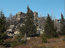
Zeter cliffs
The Zeterklippen in the Harz are striking granite rock formations on the Renneckenberg (approx. 933 m above sea level ) in the Harz district in Saxony-Anhalt . They consist of the Great Zeterklippe ( Upper Zeterklippe ; 929.7 m above sea level ; ⊙ ), the Middle Zeterklippe (approx. 866 m above sea level ; ⊙ ) and the Kleine Zeterklippe ( Lower Zeterklippe ; approx. 827 m above sea level ; ⊙ ).
Geographical location
The Zeterklippen are in the upper resin (high resin) within the natural parks resin / Saxony-indication in the National Park resin . In the extreme south of the urban area of Ilsenburg they are located on the Renneckenberg north of Schierke (zu Wernigerode ) , an eastern neighbor of the Brocken ( 1141.1 m above sea level ). The Große Zeterklippe rises on the north crest of the Renneckenberg, which is loosely wooded in its high elevations, and on its northwest flank are the Mittlere Zeterklippe and the Kleine Zeterklippe . The upper course of the Ilse flows west past the mountain in a south-north direction .
Origin of name
The origin of the name Zeterklippen has not yet been clearly established. The derivation of Zeter or Zintar or Brunnen des Ziu (Thor) is to be rejected. The connection with the Upper German call for legal or weapon aid seems unlikely . In 1407 the name appears for the first time as de Zetterberg , then in 1592 as am Zetterklebe , and in 1640 as Setterklee .
Botanical garden and work hut
Slightly below the Great Zeterklippen was formerly the work hut Matt Garden , which, as a left over from the time here botanical garden as a replacement for the inaccessible Brockengarten had been created.
Hiking and viewing opportunities
The Zeterklippen can be reached after about 2.5 km from the Molkenhausstern . The path initially leads uphill through a dense spruce forest until the view of the Hohnekamm and down to Wernigerode becomes clear. To the right there is a 0.5 km steep ascent and after about 200 m a 0.4 km flatter ascent to the Great Zeterklippe.
The Great Zeterklippe can be climbed using an iron ladder attached to the rock. From here the view falls, for example, to the Brocken , Wernigerode and the northern Harz foreland.
The Große Zeterklippe is included as No. 10 in the system of stamping points of the Harz hiking pin.
See also
Individual evidence
- ↑ Map services of the Federal Agency for Nature Conservation ( information )
- ↑ Mittlere Zeterklippe , on openstreetmap.org
- ↑ Harzer Wanderadel: stamp point 10 / Große Zeterklippe , on harzer-wandernadel.de
Web links
- Cliffs and rocks east of the Brocken ( Memento from June 11, 2007 in the Internet Archive )

