Ziegelhof (Eichstätt)
|
Brick yard
City of Eichstätt
Coordinates: 48 ° 54 ′ 5 " N , 11 ° 12 ′ 53" E
|
||
|---|---|---|
| Height : | 510 m | |
| Residents : | 9 (1987) | |
| Postal code : | 85072 | |
| Area code : | 08421 | |
|
Location of Ziegelhof in Bavaria |
||
|
Ziegelhof, seen from the south
|
||
Ziegelhof is a wasteland and a district of the city of Eichstätt in the Upper Bavarian district of Eichstätt .
location
Ziegelhof is about three kilometers northeast of Eichstätt on the plateau of the Franconian Alb .
history
In 1571, a brick factory was built on the Jura plateau northeast of Eichstätt by the Eichstätter canon and cathedral provost Ambrosius von Gumppenberg (around 1501–1574), which was also called Muggenthalerhof after the later owners. Around 1660 the court, now called Sieglhoff (probably inaccurate spelling in the source), Ziegelhof or Stadel, had to pay dues to the collegiate foundation of Our Lady of Eichstätt; The Marienpfarrkirche, rebuilt from 1472 and largely demolished in the 19th century, had been incorporated into the cathedral chapter since 1233, the collegiate monastery existed since 1316/18. Since the 18th century at the latest, the term brick yard or brick yard has been passed down throughout. In 1836 there is talk of the "Ziegelhofthal", where 16 people live in two residential buildings. Two house numbers are still assigned today. The two properties belonged to the city of Eichstätt until the beginning of the 19th century, then in the new Kingdom of Bavaria (1806) by the municipal edict of 1818 to the tax district and the municipality of Preith . On May 1, 1978 the Preith community was dissolved, and Ziegelhof returned to the city of Eichstätt. In the 20th century, the term "Mittelwimpasing" can also be found in relation to the districts of Wimpasing and Häringhof (Unterwimpasing). The dairy farm of the Brems family who runs the farm today consists of around 100 dairy cows.
Population development
- 1821: 9
- 1937: 20
- 1950: 15
- 1987: 9
Others
- The manor is a stately rectangular complex in Jura construction, marked with the year 1725.
- In 1832 a "beautiful garden" at the Ziegelhof is mentioned.
- In 1908 the farmers from Ziegelhof, Wimpasing, Häringhof and Lüften merged to form a "steam threshing machine cooperative". In 1925 this was converted to electricity; At Easter 1927 the Ziegelhof received electric light itself.
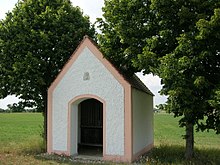
- The Antonius Chapel of the Ziegelhof was built in 1899 by the Brems brothers of the Ziegelhof. She has a roof ridge .
- At the southern entrance to the town there is a medieval cross stone , a rectangular dolomite plate with a raised cross on it.
- A field chapel at the Ziegelhof dates from the 19th century.
- A Marterl near the farm on the way to Eichstätt is reminiscent of the eight-year-old brick farm son Johann Willibald Brems, who fell from a wagon in May 1805 and died.
Personalities
- Alois Brems (1906–1987), born April 19, 1906 in Ziegelhof, Bishop of Eichstätt 1968–1984.
Transport links
Ziegelhof can be reached via a spur road that branches off from state road 2225, the so-called Jura-Hochstraße, coming up from Eichstätter Spindeltal at the transition to district road EI 21 to the east.
literature
- Franz Xaver Buchner : The diocese of Eichstätt. Volume I, Eichstätt: Brönner & Däntler, 1937.
- Gerhard Hirschmann: Historical Atlas of Bavaria. Part of Franconia. Row I, Issue 6. Eichstätt. Beilngries - Eichstätt - Greding. Munich 1959.
- Antonius Reith: Eichstätt. City and Altlandkreis. (Historical book of place names of Bavaria, 8). Munich: Commission for Bavarian State History, 2017.
Web links
Individual evidence
- ↑ Reith, p. 232; Hirschmann, p. 198
- ↑ [1] intv-video May 17, 2017
- ^ Leo Hintermayr: The Principality of Eichstätt of the Dukes of Leuchtenberg 1817–1833 . Munich: CH Beck, 2000, p. 163
- ↑ Buchner, p. 255
- ↑ Hirschmann, p. 198
- ↑ Bavarian State Office for Statistics and Data Processing (Ed.): Official local directory for Bavaria, territorial status: May 25, 1987 . Issue 450 of the articles on Bavaria's statistics. Munich November 1991, DNB 94240937X , p. 81 ( digitized version ).
- ↑ Joseph Anton Eisenmann and Carl Friedrich Hohn: Topo-geographical-statistical lexicon from the Kingdom of Bavaria, 2nd volume , Erlangen 1832, p. 74
- ↑ Historical sheets for the city and district of Eichstätt , 18 (1969), No. 6, p. 23 f.
- ↑ Buchner, pp. 235, 257
- ^ Felix Mader (arrangement): The art monuments of Bavaria. Middle Franconia administrative region. II. Eichstätt District Office. Munich: R. Oldenbourg 1928, p. 359
- ^ [2] Bayer. State Office for Monument Preservation
- ↑ The Eichstätter Raum in Past and Present , Eichstätt 1984, p. 308; [3] CV


