
Aa (Nethe)
| Aa | ||
 The Aa at Herste |
||
| Data | ||
| Water code | EN : 4526 | |
| location | North Rhine-Westphalia , Germany | |
| River system | Weser | |
| Drain over | Nethe → Weser → North Sea | |
| source | On the eastern edge of the Eggegebirge , east of Altenbeken , above the Rehberg tunnel 51 ° 46 ′ 7 ″ N , 8 ° 58 ′ 34 ″ E |
|
| Source height | approx. 350 m above sea level NN | |
| muzzle | Southwest of Brakel in the Nethe coordinates: 51 ° 42 ′ 5 " N , 9 ° 10 ′ 13" E 51 ° 42 ′ 5 " N , 9 ° 10 ′ 13" E |
|
| Mouth height | approx. 133 m above sea level NN | |
| Height difference | approx. 217 m | |
| Bottom slope | approx. 11 ‰ | |
| length | 20.6 km | |
| Catchment area | 80.153 km² | |
| Discharge at the Rustenhof A Eo gauge: 77.06 km² Location: 2.99 km above the mouth |
NNQ (08/10/1996) MNQ 1970/2014 MQ 1970/2014 Mq 1970/2014 MHQ 1970/2014 HHQ (10/28/1998) |
102 l / s 202 l / s 1.36 m³ / s 17.6 l / (s km²) 29.2 m³ / s 71.2 m³ / s |
 In a dry summer, the weak stream below Reelsen runs dry in the rubble of the stream bed. Look upstream. (August 5, 2011) |
||
The Aa is a 20.6 km long orographic left tributary of the Nethe in North Rhine-Westphalia , Germany . As a tributary of the Nethe, the Aa belongs to the Weser river system .
geography
The Aa rises on the eastern slope of the Rehberg ( 427.4 m ) belonging to the Eggegebirge at an altitude of 350 m above sea level. NN , about 2 km east of Altenbeken and above the east portal of the Rehberg tunnel in Bad Driburg - Langeland . Initially marked as Großer Wasser in the German Basic Map (DGK) (this name is taken up again as Großewasser for a parcel above Herstes ), the stream initially flows to the east and after about 2 km of the river it crosses the Herford – Altenbeken railway line . From here on it is also referred to as Aa in the German basic map. A little later, the Aa turns in a predominantly south-easterly direction and passes the village of Reelsen on its eastern edge. At Alhausen , the Rautebach flowing through the town flows out on the left , with the Aa flowing past the town a few hundred meters southwest.
East of Bad Driburg , the Schwallenbach coming from there flows into the Aa on the right. After crossing under the Altenbeken – Kreiensen railway line , the Hilgenbach also flows to the right . At Herste , the Katzbach flows again on the right side into the Aa, which is now flowing again in an easterly direction. At 8.2 km in length, the Katzbach is the longest tributary of the Aa. West of Istrup , the Escherbach joins the Aa on the left. After the river has flowed through the village of Riesel , it flows southwest of Brakel as a left tributary at 133 m above sea level. NN in the Nethe .
On its 20.6 km long path, the Aa overcomes a height difference of 217 m, which corresponds to a mean bed gradient of 10.5 ‰. The Aa drains a catchment area of 80.153 km². When there is heavy rainfall in the Egge Mountains, the Aa quickly carries large volumes of water through the Aatal.
Tributaries
- Rautebach - 2.6 km long, left tributary at 193 m above sea level. NN
- Schwallenbach - 5.0 km long, right tributary 181 m above sea level. NN
- Hilgenbach - 5.5 km long, right tributary 172 m above sea level. NN
- Katzbach - 8.2 km long, right tributary 155 m above sea level. NN
- Escherbach - 4.9 km long, left tributary 149 m above sea level. NN
A special feature is the unnamed right side stream, only a few hundred meters long, at the southernmost point of the Johannes-Gelhaus-Weg near Reelsen, where it can be viewed well. As a tufa spring , it forms small sintered terraces with the participation of mosses. In summer it falls completely dry.
Mill ditches
Reelsen, Alhausen, Istrup and Riesel still have an old mill ditch.
Ashlar bridges

There are still some preserved bridges made of ashlar along the Aa :
- At the Josefsmühle. Round bridge with an arch (replaced by a simple concrete bridge)
- Herste . Round arch bridge over the Katzbach with an arch on Heristiestraße, access
- Istrup . Round arch bridge with four arches on Istruper Straße
photos
Probably the highest source of the Aa is located directly on the forest path when you descend from Rehberg to the source of the Emmer in Langeland.

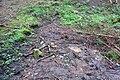
Sintered terraces that have fallen dry
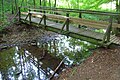
South of Reelsen, a wooden bridge leads Johannes-Gelhaus-Weg over the Aa. Look upstream. (August 5, 2011)

Bridge of the road In the stairs from Alhausen to Bad Driburg. Although the Aa below Reelsen had dried up on the surface at this point and the Rautebach was also dry, water is flowing here again. Look downstream. (August 5, 2011)


Others
See also: List of waters with Aa
Individual evidence
- ↑ a b c d e f g Topographic map 1: 25,000
- ↑ a b c d e f g h Topographical Information Management, Cologne District Government, Department GEObasis NRW
- ^ German Hydrological Yearbook Weser-Ems 2014. Lower Saxony State Agency for Water Management, Coastal Protection and Nature Conservation, p. 157, accessed on October 4, 2017 (PDF, German, 8805 kB).